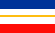
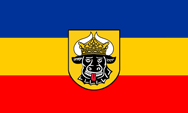
seit 29.01.1991,
Landesdienstflagge,
Seitenverhältnis = 3:5,
Quelle, nach: Wikipedia (D)


Flagge für die mecklenburgischen Gebiete des Landes,
Seitenverhältnis = 3:5,
Quelle, nach: Wikipedia (D)


Flagge für die pommerschen Gebiete des Landes,
Seitenverhältnis = 3:5,
Quelle, nach: Wikipedia (D)

1947–1952,
Flagge des Landes Mecklenburg in der DDR
Seitenverhältnis = 3:5,
Quelle, nach: Flags of the World
1990–1991,
Flagge des Landes in der DDR, inoffiziell
Seitenverhältnis = 3:5,
Quelle, nach: World Statesmen, Wikipedia (D)
Als Mecklenburg im Jahre 1945 Vorpommern angegliedert bekam, im Jahre 1949 Land der DDR wurde, hat man die Flagge Mecklenburgs, die blau-gelb-rote Trikolore, unverändert übernommen. Nach der Neugründung des Landes – als Mecklenburg-Vorpommern – wurde eine neue Flagge angenommen, welche die Farben beider Landesteile kombiniert:
• Mecklenburg (blau-gelb-rot)
• Preußische Provinz Pommern (blau-weiß)
Mit dem Design der Flagge gelingt es außerdem, die alte blau-weiß-rote Landesflagge von Mecklenburg mit den Landesfarben Blau, Gelb und Rot zu kombinieren. Das traditionelle Symbol Mecklenburgs ist der Stierkopf, der in der heutigen Dienstflagge und im heutigen Landeswappen durch den pommerschen Greif ergänzt wird.
Quelle:
Volker Preuß
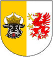
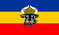
kleines Wappen von Mecklenburg-Vorpommern,
Quelle, nach: Wikipedia (D)
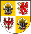
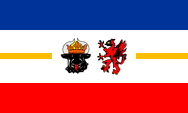
großes Wappen von Mecklenburg-Vorpommern,
Quelle, nach: Wikipedia (D)
Das kleine Wappen zeigt einen gespaltenen Schild, vorne golden mit einem schwarzen Stierkopf, hinten silbern mit einem roten Greifen, und verbindet so die Heraldik von Mecklenburg (Stierkopf) mit der von Pommern (Greif), so wie der Landesname beide geographische Begriffe verbindet. Das große Wappen zeigt einen gevierteilten Schild, im ersten und vierten Feld die Heraldik von Mecklenburg, im zweiten die von Pommern, und im dritten die von Brandenburg (roter Adler auf Silber). Das Wappen zeigt so an, aus welchen Territorien welcher historischen Länder sich das Bundesland Mecklenburg-Vorpommern heute zusammensetzt.
Quelle: Wikipedia (D),
Volker Preuß
Die BRD und ihre Länder, interaktive Karte:
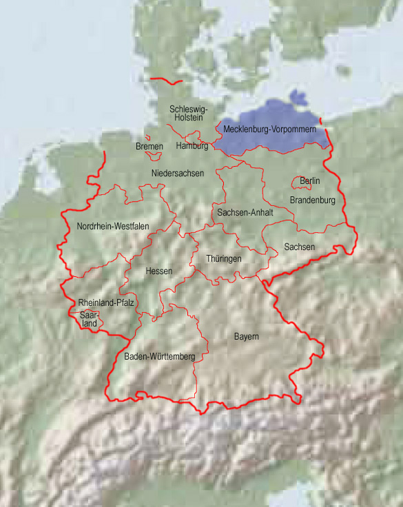
Quelle: Freeware, University of Texas Libraries, modyfied by: Volker Preuß
Fläche: 23.180 km²
Einwohner: 1.630.000 (2012)
Bevölkerungsdichte: 70 Ew./km²
Religionen: 17% Protestanten, 3% Katholiken
Hauptstadt: Schwerin, 95.000 Ew. (2010)
Amtssprache: Deutsch
sonstige Sprachen: Niederdeutsch
Quelle: Wikipedia (D)
09.07.1945 · zunächst Besetzung durch US-amerikanische, britische und sowjetische Truppen, danach Abzug der Briten und US-Amerikaner, Angliederung von Vorpommern und kleinerer brandenburgischer und hannoverscher Gebiete an Mecklenburg, das Land kommt als "Mecklenburg-Vorpommern" zur sowjetischen Besatzungszone
01.03.1947 · Umbenennung in "Mecklenburg"
1949–1952 · Land der DDR
1952–1990 · aufgelöst
03.10.1990 · als "Mecklenburg-Vorpommern" wieder gegründet, ein Bundesland der BRD
Geschichte von Mecklenburg → hier klicken
Quelle/Source: World Statesmen,
Wikipedia (D),
Volker Preuß
Der Name Mecklenburg-Vorpommern ist ein Hinweis darauf, dass sich das Land im wesentlichen aus zwei Landesteilen zusammensetzt, 1.) Mecklenburg, 2.) Vorpommern. Der Name Mecklenburg wird erstmals in einer Urkunde aus dem Jahr 995 als 'Mikelenburg' erwähnt. Damit war eine slawische Burg gemeint, die Burg 'Wiligrad', denen Namen ins Niederdeutsche übertragen wurde. Denn 'Wiligrad' heißt in der Sprache der Obodriten und auf Niederdeutsch "große Burg" ("miekel“ = groß). Die Herren der Mikelenburg, Fürsten vom Stamm der Obodriten wurden später die Herren des ganzen Landes und sogar Reichsfürsten. Sie regierten bis 1918. Die Provinz Pommern erstreckt sich entlang der Ostseeküste, vom Darß einschließlich Rügen bis zur Danziger Bucht. Die Oder und das Oderhaff teilen das Land in einen westlichen Teil (Vorpommern) und einen östlichen Teil (Hinterpommern). Vorpommern wurde 1945 mit Mecklenburg zum Bundesland Mecklenburg-Vorpommern vereint. Der Name der Provinz Pommern geht auf den bis zum 13. Jahrhundert hier siedelnden slawischen Stamm der Pomoranen zurück. Der slawische Begriff "po-morju" heißt "am Meer", und veranschaulicht die Lage des Landes.
Quelle: Wikipedia (D),
Volker Preuß