Zipser Land

  • Zipser Land (Zips)
    · deutsch: Zips
    · slowakisch: Spiš
    · ungarisch: Szepes
    · polnisch: Spisz
    · lateinisch: Scepusium
  • ehemaliges ungarisches Komitat
    in der östlichen Hohen Tatra
  • der Zipser Land gehört heute
    größtenteils zur Slowakei
  • Zips Country
    · German: Zips
    · Slovak: Spiš
    · Hungarian: Szepes
    · Polish: Spisz
    · Latin: Scepusium
  • former Hungarian comitate (district)
    in the eastern High Tatra Mountains
  • Zips Country belogs today
    mostly to Slovakia
Übersicht – Contents:


Flagge – Flag:

Flagge Zipser Land Das Zipser Land hatte wahrscheinlich keine eigene Flagge, aber ein Wappen, und daraus lassen sich die Landesfarben herleiten.
– The Zips Country had probably not have its own flag, but a coat of arms, and from there  the colours can be derived.

hoch/up


Wappenschild – Blazon:

Wappen Zipser Land Zips Wappen des Komitats Zips
– coat of arms of the District of Zips

hoch/up


Bedeutung/Ursprung des Wappens: Meaning/Origin of the Coat of Arms: Das Wappen des Zipser Lands zeigt unter anderem typisch ungarische Heraldik, so taucht der grüne Dreiberg auf, aber auch die stilisierte ungarische Krone, ebenso eine Lilie, die wohl an die ungarischen Könige aus dem Haus Anjou im 13. und 14. Jahrhundert erinnern soll. The coat of armsof Zips Country shows, among others, typical Hungarian heraldry, so arises the green triple-mountain three, but also the stylized crown of Hungary, and further a lily that should probably remember the Hungarian kings from the House of Anjou in the 13th and 14th century. Quelle/Source: Volker Preuß

hoch/up


interaktive Landkarte Österreich-Ungarns mit dem Zipser Land
– interaktive Map of Austria-Hungary with the Zips Country:

interaktive Landkarte – interactive Map
ca. 1910
Landkarte/Map: Volker Preuß hoch/up


Zahlen und Fakten – Numbers and Facts:
  • Fläche:
    3 654 km² (1910)
  • Area:
    1 410 square miles (1910)
  • Einwohner:
    173 000 (1910)
    davon
    58% Slowaken
    25% Deutsche
    8% Russinen (Ukrainer)
    6% Ungarn
  • Inhabitants:
    173 000 (1910)
    thereof
    58% Slovaks
    25% Germans
    8% Russins (Ukrainians)
    6% Hungarians
  • Bevölkerungsdichte:
    47 Ew./km² (1910)
  • Density of Population:
    123 inh./sq.mi. (1910)
  • Hauptstadt:
    Leutschau (Levoca)
  • Capital:
    Leutschau (Levoca)
  • heutige Sprachen:
    Slowakisch, wenig Deutsch
  • today's Languages:
    Slovak, some German
  • Zeitzone:
    MEZ
  • Time Zone:
    GMT - 1 h
Quelle/Source: Wikipedia (D)

hoch/up


Geschichte: ca. 1050 · Eroberung durch das Königreich Ungarn
12. Jahrhundert · Bildung des Comitats Zips
1242 · Mongoleneinfall, das Land wird verwüstet, in den Folgejahren werden durch den ungarischen König deutsche Bergleute und Siedler (aus Schlesien, Sachsen und Thüringen) ins Land gerufen, Gründung zahlreicher Städte und Gemeinden, Gründung des Bundes der 24 Zipser Städte
1412 · der Bund der 24 Zipser Städte wird aufgelöst, 13 von ihnen an Polen verpfändet, die übrigen erleben einen wirtschaftlichen Niedergang
1772 · Erste polnische Teilung, die 13 Städte kommen zurück an Ungarn
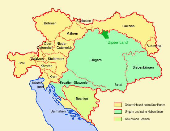
1919 · im Zuge der Auflösung Österreich-Ungarns kommt das Zipser Land an die Tschechoslowakei, Polen besetzt 195 km² des Zipser Lands
1923 · das Zipser Land wird in angerenzenden Bezirken aufgeteilt
1939–1945 · das ehemalige Zipser Land ist Bestandteil der unabhängigen Slowakei
1944–1945 · Zweiter Weltkrieg, Flucht der vor allem deutschen Einwohnerschaft vor der Roten Armee, die nach Kriegsende meist zurückkehren
1946 · Vertreibung und Aussiedlung der deutschen und ungarischen Bevölkerung, ca. 1000 Deutsche verblieben bis heute in der Region
hoch/up


History:
about 1050 · conquest by the Kingdom of Hungary
12th century · formation of the Comitate of Zips
1242 · Mongol invasion, the country is devastated, in the following years were German miners and settlers (from Silesia, Saxony and Thuringia) were brought into the country by the Hungarian king, founding of numerous towns and cities, establish of the 24 Federal Zips Cities
1412 ·  the confederation of the 24 Federal Zips Cities becomes resolved, 13 of them become pledged to Poland, the remaining cities come in economic decline
1772 · First Partition of Poland, the 13 cities come back to Hungary
1919 · on the occasion of the dissolution of Austria-Hungary, Zips Country comes to Czechoslovakia, Poland occupies 75 square miles of Zips Country
1923 · Zips Country becomes divided between bordering districts
1939–1945 · former Zips Country becomes a part of the independent Slovakia
1944–1945 · Second World War, flight of the mostly German population, from the Red Army, they mostly returned after the war
1946 · expulsion and deportation of the German and Hungarian population, about 1000 Germans remain until today in the region
Quelle/Source: Wikipedia (D), Volker Preuß hoch/up


Ursprung des Landesnamens: Origin of the Country's Name: Die Bezeichnung "Zipser Land" ist von der Burg Zips abgeleitet. Sie war insbesondere seit der Zeit der Mongoleninvasion das administrative Zentrum der Region, bis Leutschau zur Hauptstadt wurde. Seit 1780 ist die Burg verlassen und befindet sich im Verfall. The term "Zips Country" is derived from the castle of Zips. It was the administrative center of the region, especially since the time of the Mongol invasion, until the capital became Leutschau.
Since 1780 the castle is abandoned and in decline.
Quelle/Source: Wikipedia (D), Volker Preuß

hoch/up


Zur Startseite hier klicken