Äquatorial-Guinea |
|
|
|
| Übersicht – Contents: | |
Äquatorial-Guinea |
|
|
|
| Übersicht – Contents: | |
Flaggen – Flags: |
|
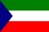 |
Nationalflagge
– national flag,
|
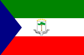 |
Staats-
und Marineflagge
|
historische Flagge – historical Flag: |
|
 |
1973–1979, Nationalflagge – national flag, Quelle/Source nach/by: Flags of the World
|
Bedeutung/Ursprung der Flagge – Meaning/Origin of the Flag: |
|
| Die Flagge Äquatorial-Guineas zeigt drei waagerechte Streifen in Grün, Weiß und Rot mit einem flachen blauen Dreieck am Liek. Die Staats- und Marineflagge führt zusätzlich im weißen Mittelstreifen das Staatswappen. Die Flagge wurde am 12.10.1968 anlässlich der Unabhängigkeit von Spanien eingeführt. Blau steht für das Meer, Grün für die Landwirtschaft und die Naturschätze, Weiß für den Frieden und Rot für das im Kampf um die Unabhängigkeit vergossene Blut. | The flag of Equatorial Guinea shows three horizontal stripes in green, white and red, with an flat blue triangle in the leech. The state- and naval flag carrys further in the white centre-stripe the coat of arms of the state. The flag was introduced on 12th of October in 1968 on occasion of the independence from Spain. Blue stands for the ocean, green for the agriculture and the nature-treasures, white for the peace and red stands for the in the struggle for indpendence given blood. |
| Quelle/Source: Die Welt der Flaggen, Flaggen Wappen Hymnen | |
Wappen – Coat of Arms: |
|
 |
Wappen von
Äquatorial-Guinea – coat of arms of Equatorial Guinea, Quelle/Source: Corel Draw 4, Wikipedia (D) |
Bedeutung/Ursprung des Wappens – Meaning/Origin of the Coat of Arms: |
|
| Im Staatswappen ist auf einem silbernen Schild ein Mangrovenbaum abgebildet, darüber sechs goldene sechszackige Sterne. Nach anderen Quellen, soll der Baum angeblich ein Maulbeerbaum sein, unter dem in der Mitte des neunzehnten Jahrhunderts die Spanier und König Bonkoro von Bata einen ersten Vertrag abschlossen. Die goldenen Sterne über dem Wappen symbolisieren das Festlandsgebiet und die fünf Inseln des Staates. Unter dem Schild lautet die Aufschrift: "Einheit, Frieden, Gerechtigkeit". Zwischen 1973 und 1979, in der Zeit der Herrschaft von Macia Nguema, galt vorübergehend ein anderes Wappen. | In the arms is to see a
mangrove-tree on a silver shield, over there are six golden six-jaged stars jag. By other
sources should the tree allegedly be a mulberry tree, under which in the middle og the
nineteenth century the Spanish and king Bonkoro of Bata came to their first agreement. The
six stars above the shield symbolize the mainland and the five islands of the country.
Beneath the shield the inscription: "Unity, Peace, Justice". Between 1973 and 1979, in the time of the rule of Macia Nguema, was valid an other coat of arms. |
| Quelle/Source: Die Welt der Flaggen, Flaggen Wappen Hymnen | |
Flugzeugkokarde – aircraft roundel: |
|
 |
Flugzeugkokarde – aircraft roundel Quelle/Source: nach/by Wikipedia (EN) |
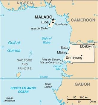
Landkarte – Map: |
Die
Lage Äquatorial-Guineas – position of Equatorial Guinea: |
Äquatorial-Guinea – Equatorial Guinea: |
Zahlen und Fakten – Numbers and Facts: |
|
|
|
|
|
|
|
|
|
|
|
|
|
|
|
|
|
Geschichte: |
|
1474 · Eroberung der Inseln durch Portugal 1778 · Eroberung der Inseln durch Spanien 1843 · Eroberung des Festlands durch Spanien 29.07.1968 · Unabhängigkeit |
History: |
|
1474 · conquest of the islands by Portugal 1778 · conquest of the islands by Spain 1843 · conquest of the mainland by Spain 29th of July 1968 · independence |
| Quelle/Source: Atlas zur Geschichte, Wikipedia (D) |
Ursprung des Landesnamens – Origin of the Country's Name: |
|
| Der Name "Guinea" beschrieb früher die gesamte Westküste Afrikas zwischen Kap Dakar und Kap Lopez. Er geht auf die Bezeichnung "aguinaou" zurück, ein Wort mit dem die Tuareg die Völker südlich der Sahara bezeichnen: "Schwarze". | The name
"Guinea" described earlier the entire west coast of Africa between Cape Dakar
and Cape Lopez. It goes back to the name "aguinaou", a word of the Tuareg, to describe peoples south of the Sahara: "Blacks". |
| Quelle/Source: Handbuch der geographischen Namen | |