mobile View, to the German Version tap the flag


- secessionist region in Burma
• Flag
• Numbers and Facts
• History
• Additional text about history
• Map

National flag,
Source, by: Die Welt der Flaggen


This country is a theoretical construct that a separatist movement is striving for as a goal for an independent state. The parameters that roughly describe this goal are listed here. This has nothing to do with an actual – neither partial nor complete – existence of this area, country or state.
Area: ca. 11.500 square miles
Inhabitants: ca. 2.100.000
Capital: Akyab, 110.000 inh.
Language: Burmese
Time Zone: GMT + 6,5 h
Source: Wikipedia (EN)
ca. 1580 to 1750 · State of Arakan
1784 · to the Awa-Empire (Burma)
1826 · British conquest
1937 · on the occasion of the detachment of Burma from British-India Arakan became Burmese
1942–1945 · occupied by Japanese troops
4th of January 1948 · independence of Burma
Source: Atlas zur Geschichte
The Arakan belong to the ethnic group of the Burmans, are of Tibeto-Burman origin and entered after the beginning of our era in time in different waves into Burma and settled in the west of the country, especially the area between the Bengal Sea and the Arakan Yoma Mountains – which from there is called Arakan. The Arakans are in their majority Muslims. Arakan became from 1824 to 1826 conquered by the British, colonized and connected to British India. In 1937, Arakan, although it is inhabited mostly by Muslims, became Burmese on the occasion of the detachment of Burma from British-India. So there arised conflicts between the Burmans and the Muslims in Arakan. The Arakans began an armed struggle against Burma's central government for an independent Arakan, which continues to this day.
Source:
Volker Preuss
Clickable map of the separatist areas in the region:
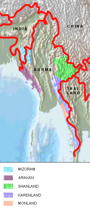
Source: Map is Freeware, University of Texas Libraries, modyfied by: Volker Preuss
