Lord-Hove-Insel |
|
|
|
| Übersicht – Contents: | |
Lord-Hove-Insel |
|
|
|
| Übersicht – Contents: | |
Flagge – Flag: |
|
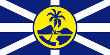 |
inoffizielle Flagge – unofficial flag, Seitenverhältnis – ratio = 1:2, Quelle/Source nach/by: Flags of the World
|
Bedeutung/Ursprung der Flagge – Meaning/Origin of the Flag: |
|
| Die Flagge wurde 1993 von John C. Vaughan aus Sydney entworfen und 1998 erstmals auf der Insel gehisst. Sie ist nicht offiziell, hier wird amtlich die Flagge Australiens verwendet. Dies Gestaltung geht auf die Kommandoflagge von Lord Richard Howe während der Seeschlacht bei Ouessant (1778) gegen Frankreich zurück. Lord Howe war britischer Flottenadmiral und Erster Lord der Admiralität. Die blaue Flagge zeigt, wie die damalige britische Flagge, ein Georgskreuz und ein Andreaskreuz und in der Mitte eine goldene Scheibe, die für die Sonne steht. Auf der Scheibe findet sich die Slihouette der Insel. Das Flaggenbild soll reflektierende Sonnenstrahlen auf blauem Wasser darstellen. | The flag was designed in 1993 by John C. Vaughan from Sydney and it was first hoisted on the island in 1998. It is not official, the flag of Australia is used here. The design goes back to the command flag of Lord Richard Howe during the naval battle of Ouessant (1778) against France. Lord Howe was the British Naval Admiral and First Lord of the Admiralty. The blue flag shows, like the British flag of that time, a St. George's cross and a St. Andrew's cross and in the middle a golden disc, which stands for the sun. The silhouette of the island can be found on the disk. The flag image is intended to show reflective rays of the sun on blue water. |
| Quelle/Source: Flags of the World | |
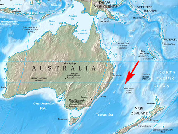
| Landkarte – Map: |
|
Zahlen und Fakten – Numbers and Facts: |
|
|
|
|
|
|
|
|
|
|
|
|
|
|
|
|
|