mobile View, to the German Version tap the flag


- sezessionist state in the north of Mali
• Flag
• Meaning/Origin of the Flag
• Map
• Numbers and Facts
• History
• Origin of the Country's Name
2012,
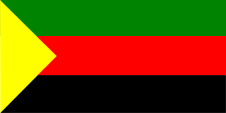
National flag,
ratio = 1:2,
Source, by: Wikipedia (D)


The flag of Azawad is the flag of the MNLA (National Movement for the Liberation of Azawad). It was probably adoped in the year 2012. In the region occured since the early 90's riots and Tuareg rebellions, a nation which not only in Mali sees itself as a nation of second class. The MNLA was probably formed by returning soldiers of the former Libyan dictator Gaddafi. During the year 2012, the MNLA succeeded in bringing large areas of the north of Mali under their control, and on 6th of April in 2012 they proklaimed the Independent State of Azawad.
The flag of Azawad shows three horizontal stripes in green, red and black, and a rectangular yellow triangle on the leech. The colours green, yellow and red are the Pan-African colours. The Pan-African-Movement had its beginnings perhaps in 1900, which wants to emphasize the common goals of all black people. The colour-triad green-yellow-red, which are used by many African and even American countries in their flags after independence, stands for the political unity of Africa, of all black People. The first country was Ghana in 1957. As the origin, the colours of Ethiopia (Abessinia), the oldest independent state in Africa, apply.
The combination of the colours red, black and green is named Garvey-colours. They are those colours who created Markus Garvey in 1917 for the flag of the United Negro Improvement Association, which was striped in this colours. He was a supporter of the "Back-to-Africa"-Movement and saw in them the colours of a state of Blacks, which should be accomplished in Africa. But the colours get known in the USA and in the Caribic as the colours of the Black-Power-Movement, and get in Africa few persuasion. Nevertheless this colour-combination is sometimes named as Panafrican Colors too.
Source: Volker Preuß,
Die Welt der Flaggen
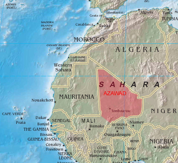
Map: Freeware, University of Texas Libraries, modyfied by: Volker Preuß
This country is the goal of a separatist movement for an independent state. The here listed parameters describe this goal roughly. This has only partially to do with the actual existence of this territory.
Area (claimed): 317 375 square miles
Inhabitants (claimed): ca. 1.300.000
Density of Population: 4 inh./sq.mi.
Capital (claimed): Gao, 86.633 inh. (2009)
Languages: French, Arabic, Languages of the Songhai, Tuareg and Fulbe
Currency: no own currency
Time Zone: GMT
Source: Wikipedia (D),
Länder der Erde
1076–1077 · conquest by the Almoravides, disintegration of the Ghana Empire, Islamization
1100 · foundation of Timbuktu by the Tuareg people
1235–ca. 1465 · Mali Empire
ca. 1465–1591 · Songhai Empire
1591 · Moroccan conquest
1760 · the Tuareg rule the country
1883–1898 · French conquest, establishment of the colonies Upper Senegal and Niger (later French-Sudan)
1895 · establishment of the Government General French West Africa
1902 · establishment of the colonial federation of French West Africa consisting of:
1st) Mauritania – French Sudan – Niger Colony – Uppervolta
2nd) Senegal
3rd) Dahomey
4th) Ivory Coast
5th) French Guinea
28th of November 1958 · proclamation of the Republic of Sudan, autonomy within the French Community
17th of January 1959 · confederation with Senegal to the Federation of Mali (Sudan and Senegal)
22nd of November 1960 · disintegration of the Federation of Mali, France grants independence, Sudan adopes the name Mali
1961 · formation of the "Union of African States" (Mali, Ghana and Guinea)
1963 · disintegration of the "Union of African States"
1990 · after riots state of emergency in the Tuareg area
1991 · riots
1995 · end of the Tuareg revolt
2012 · in January 2012 outbreak of a renewed Tuareg rebellion, in March Kidal and Gao become conquered by the MNLA Militia (Movement Nationale de Libération de l'Azawad) and the Islamic Ansar-Dine Militia, on 1st of April in 2012 followed by Timbuktu
6th of April 2012 · Azawad declares its independence from Mali, the Islamic Ansar-Dine Mitia recognizes Azawad not, and expels in the following days the MNLA from Timbuktu
8th of April 2012 · Arabs expelled from Timbuktu found the FNLA Militia (Front Nationale de Libération de l'Azawad)
Source: Weltgeschichte,
Atlas zur Geschichte,
1. Wikipedia (D),
2. Wikipedia (D)
The name Azawad (French also Azaouad) goes back to the same named landscape between the River Niger and the Aïr Mountains in the State of Niger.
Source: Wikipedia (D)
