mobile View, to the German Version tap the flag


- Republic of Biafra
- 1967–1970 independent
- since then secessionist region within Nigeria
• Flag
• Meaning/Origin of the Flag
• Coat of Arms
• Meaning/Origin of the Coat of Arms
• Aircraft Roundel
• Map
• Numbers and Facts
• History
• Origin of the Country's Name
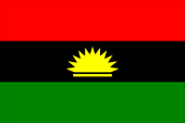
National flag,
ratio – ratio = 2:3 (1:2),
Source, by: flag-of-biafra.biafranet.com


The State of Staat Biafra was actually the by the ethnic group of Ibo dominated eastern region of Nigeria, wich separated itself from Nigeria, even due to the dissection of the four previous regions in the year 1967, and in the course of a extreme sanguinary civil war was annexed by Nigeria again until 1970, and got segmented into five federal states. The flag of Biafra shows three horizontal stripes in red, black and green. In the center a golden rising sun. The flag remembers the heraldry of the former Nigerian eastern region.
The colors red, black and green could be derived from the Garvey colors, because the color sequence of red, black and green is so named. They are those colors which were created by Markus Garvey in 1917 for the flag of the United Negro Improvement Association, which was striped in this colors. He was a supporter of the "Back-to-Africa"-Movement and saw in them the colors of a state of Blacks, which should be created in Africa. But the colors became known in the USA and in the Caribic as the colors of the Black - Power - Movement, and get in Africa only few persuasion (e.g. Malawi, Kenya, Biafra). Nevertheless this color combination is sometimes named as Panafrican Colors. Red stands for the enthusiasm and sacrifice-willingness of the people and for the in the struggle for indpendence given blood, black stands for the people and its endurance, and green for the fruitfulness of the land.
Source:
Die Welt der Flaggen,
Wikipedia (EN)

1967–1970,
Coat of arms of Biafra,
Source:
Wikipedia (EN), Public domain, via Wikimedia Commons, Fenn-O-maniC, CC BY-SA 4.0, via Wikimedia Commons
The Republic of Biafra has adopted its coat of arms almost unchanged from the former Nigerian eastern region. The blazon showed in the upper part a golden rising sun on black ground. In the lower part the shield was three-pieced by a fork cut. The three fields showed the colors green, black and red. Medial above the fork cut was positioned an ornament from three golden horseshoed pieces of jewellery. Instead of leopard and warrior served at the Biafra arms two leopards as supporters.
Source:Wikimedia Commons,
Volker Preuss

Aircraft Roundel,
Source, by: Wikipedia (EN)

Source: Eric Gaba (Sting - fr:Sting), CC BY-SA 3.0, via Wikimedia Commons
Area: 29.848 square miles
Inhabitants: 13.500.000 (1967), thereof 80% Ibo (mostly Christian and some Animist)
Density of Population: 452 inh./sq.mi. (1967)
Capital: Enugu, 280.000 inh. (1997)
Languages: English, Ibo
Currency: 1 Biafra Pound (£) = 20 Shilling = 240 Pence
Time Zone: GMT + 1 h
Source: Wikipedia (EN)
15th of January 1966 · military coup d’état in Nigeria, takeover by Mayor General J. Aguiyi Ironsi from the Ibo nation
28th of July 1966 · military coup d’état in Nigeria by North Nigerians, prohibition of all parties
29th of July 1966 · assassination of J. Aguiyi Ironsi
1966/1967 · assassination of 30.000 Ibo in whole Nigeria, getaway of two millions of Ibo in their eastern region
28th of May 1967 · formation of 12 Nigerian federal states instead of the regions
30th of May 1967 · declaration of independence of the eastern region as Republik of Biafra under Lieutenant Colonel Chukwuemeka O. Ojukwu
7th of July 1967 · start of the war between Nigeria and Biafra, the United Kingdom and the Soviet Union support Nigeria militarily and politically
10th to 26th of July 1967 · Nigerian troops conquer the places Ogoja and Nsukka in the north as soon as Bonny Island in the South
9th of August 1967 · Biafran troops under Albert Okonkwo cross the Niger River, the western border boundary of Biafra
19th of September 1967 · Albert Okonkwo proclaims in the occupied area the Republic of Benin
20th of September 1967 · Nigerian troops smash the Republic of Benin and conquer back the occupied area western the Niger River
28th of September 1967 · the capital Enugu is conquered by Nigerian troops, the seat of government becomes transfered to Unuhaia
28th of May 1968 · Port Harcourt is conquered by Nigerian troops, Biafra is cutted off from the supply and shoved on a tenth of its area, France and some African states give humanitarian help, installation of an airlift from the Portugese Island São Tomé, anyhow will starve two million human beings to 1970
13th of April to 20th of May 1968 · political recognition of Biafra by Tanzania, Zambia, Ivory Coast, and Gabon
22nd of March 1969 · political recognition of Biafra by Haiti
22nd of April 1969 · Unuhaia is conquered by Nigerian troops, the seat of government becomes transfered to Owerri
9th of January 1970 · Owerri is conquered by Nigerian troops
12th of January 1970 · Biafra becomes officially annexed back to Nigera
15th of January 1970 · Biafra surrenders, President Ojukwu exiles in the Republic of Ivory Coast, the MASSOB-Guerilla maintains the fight in the underground until today
1982 · Chukwuemeka O. Ojukwu becomes amnestyed
Source: World Statesmen,
Wikipedia (D),
Wikipedia (EN)
The name of the Republic of Biafra has its roots in the "Bay of Biafra", the eastern part of the Golf of Guinea with its 600 kilometers long coast. To erase the memories about the Republic of Biafra orders the government of Nigeria in the year 1973 the renaming of the Bay of Biafra in "Bay of Bonny".
Source: Wikipedia (D)
