Flag of the today's German minority in Warmia and Masuria,
ratio = 3:5


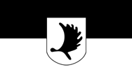
Flag of Masuren (Masuria),
ratio = 3:5,
Source, by:
Historische Masurische Vereinigung

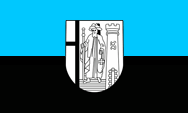
Flag of the Prince-Bishopric of Ermland (Warmia),
(reconstruction following the arms)
ratio = 3:5
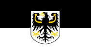
Flag of the Landsmanship of East Prussia,
ratio = 3:5


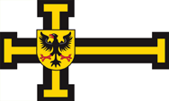
Flag of the Teutonic Order (Teutonic Knights),
ratio = 3:5
Flag of the High-Master of the Teutonic Order (Teutonic Knights),
ratio = 3:5
The flag of the province East Prussia is combination from the prussian colours black and white. The flag of Prussia goes back to the oath of fiefdom of Albrecht of Hohenzollern to the Polish king. He gave Albrecht the coat of arms: a black Polish eagle on a silvery (white) background. The colors were probably not chosen at random, because Albrecht was the last Grand Master of the Teutonic Order, whose colors were black and white (black cross on white background).
From 1875, the provinces of Prussia could largely operate in self-governing. There was a provincial parliament and a provincial government (Provincial Committee). Each province had its own colors (Landesfarben), which were also used as flag, and they had also their own coat of arms. If the provincial governments put for official purposes (official flag) their coats of arms on a flag with the provincial colors is not handed down beyond doubt and not for all provinces.
Another incident for the flag was the seizure of power by the National Socialists in the German Empire in 1933. All official non-swastika flags, that refered to federalism, regional references or the old German Empire were abolished between 1933 and 1935. For the National Socialists, the federal structure of the German Empire, its historically grown countries, was considered as outdated, as relics of a past to be overcome. In this sense, several laws were enacted, on 31st of March in 1933 the 'Provisional Law for the phasing of the countries with the Empire', on 7th of April 1933 the 'Second Law for the phasing of the countries with the Empire' and finally, on 30th January in 1934 the 'Law on the rebuilding of the empire'. Thus, the federal structure of the German Empire was replaced by the gau-structure of the NSDAP, the countries became meaningless. From now on, offices and authorities had to use the swastika flag as official flag, until September 15th in 1935, when by the flag-law was legislated a new created official flag for all the offices and authorities of the empire. The prime ministers of the countries, which latest in 1933 all came from the NSDAP – now mostly called Reichsstatthalter (maybe translated as 'governor') – however remained in office until 1945. This was then also applied on the provinces of the state of Prussia. Their sovereign duties were taken over by the Gau structure of the NSDAP, which sometimes coincided with the borders of the provinces and sometimes they were new created. The respective provincial flags disappeared. The corresponding country colours continued, with restrictions, but definitly not in the form of flags. They were used, for example, occasionally on uniforms of the SA or in some ranks of the Hitler Youth in the breast cord.
After the war, the administration within the German Empire was rebuilt, but locally, following the structure of the countries. These have been partly old countries, and some new countries were created. Sometimes they bethought the old country colours and reactivated them – or they created new ones – for limited sovereign duties, which were under the control of the Allies. However, the eastern parts of Prussia were occupied by Soviet troops from 1944, and most of them came under Polish or Russian administration. The process described above did not come into being, the German population was forcibly expelled and the old regional flags no longer played a role.
Source: Volker Preuß,
Jürgen Kaltschmitt,
Uniform-Fibel
1466–1772,
Coat of arms of Royal Polish Prussia,
Source, by: Snamjena Germanii
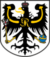
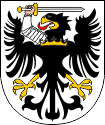
Coat of arms of East Prussia,
Source, by: Wikipedia (D)
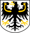
Coat of arms of East Prussia on the today in trading usual flag
The origins of the Prussian heraldry can be found in Royal Polish Prussia when these areas (Pomerelia [later West Prussia], Kulm Land, Marienburg and Elbing) were ceded to the Kingdom of Poland in 1466 and became a fief of the Polish king. A coat of arms was created for this country. It showed the Polish eagle in black on a silver (white) background with a sword arm. The colors were probably not chosen at random, after all, the Royal Polish Prussia was previously a territory of the Teutonic Order, the colors of the order were black and white (black cross on a white background). In 1525, Grand Master Albrecht converted the remaining State of the Teutonic Order (in principle the area of what would later become East Prussia, but without the Diocese of Warmia) into the secular Duchy of Prussia, Albrecht became the duke and swore the oath of fief to the Polish king. Another coat of arms was created for this, again according to the same principles. It showed the Polish eagle in black on a silver (white) background and it had a crowned breastplate with the initial "S" of the Polish king Sigismund. The coat of arms of Prussia was thus created. Later, when Prussia was divided into provinces, this original Prussian coat of arms became the coat of arms of the province of East Prussia, but without the breastplate with the "S", which had already become obsolete in 1557 when the Polish feudal sovereignty ceased to exist. On the occasion of the Polish divisions, Prussia was able to gain Royal Polish Prussia in 1772. Its coat of arms (the eagle with the sword arm) was adopted for the later province of West Prussia.
Source: Volker Preuß
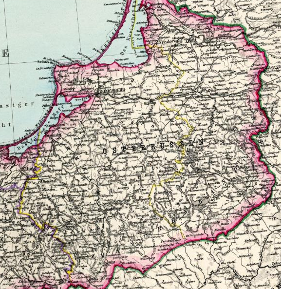
Source: Stielers Hand-Atlas, Justus Perthes, 1891
Area: 14.278 square miles (1885)
Inhabitants: 1.959.475 (1885)
Density of Population: 137 inh./sq.mi. (1885)
Capital: Königsberg
Source: Meyers Konversationslexikon
13th cent. · appropriation by the Order of the German Knights (Teutonic Knights)
1525 · creation of the Duchy of Prussia
1618 · to the brandenburgish house of the Hohenzollern
1701 · creation of the Kingdom of Prussia
1813 · liberation wars against Napoléon I.
1815 · creation of the Province of East Prussia
1824–1878 · united with West Prussia to the Province of Prussia
1920 · ceding of Soldau to Poland, ceding of the Memel Area to the allies
Oktober 1944 · East Prussia came into a military battue → 614.000 dead civil persons
1945 · division of East Prussia in a Soviet and a Polish zone, expulsion of the remained German population
Source:
Atlas zur Geschichte,
Wikipedia (D),
Schwarzbuch der Vertreibung,
Discovery '97
Regierungsbezirk Allenstein (District of Allenstein):
Allenstein 1 304 km²
Allenstein (Stadt) 52 km²
Johannisburg 1 684 km²
Lötzen 897 km²
Lyck 1 115 km²
Neidenburg 1 146 km²
Ortelsburg 1 703 km²
Osterode 1 536 km²
Rössel 851 km²
Sensburg 1 232 km²
Regierungsbezirk Gumbinnen (District of Gumbinnen):
Angerburg 929 km²
Darkehmen 759 km²
Goldap 993 km²
Gumbinnen 729 km²
Insterburg (Stadt) 44 km²
Insterburg 1 131 km²
Niederung 1 003 km²
Pillkallen 1 061 km²
Stallupönen 704 km²
Tilsit (Stadt) 59 km²
Tilsit-Ragnit 1 100 km²
Treuburg 856 km²
Regierungsbezirk Königsberg (District of Koenigsberg):
Bartenstein 866 km²
Braunsberg 946 km²
Fischhausen 1 047 km²
Gerdauen 844 km²
Heiligenbeil 908 km²
Heilsberg 1 096 km²
Königsberg 969 km²
Königsberg (Stadt) 98 km²
Labiau 1 066 km²
Mohrungen 1 265 km²
Preußisch-Eylau 1 242 km²
Preußisch-Holland 858 km²
Rastenburg 873 km²
Wehlau 1 067 km²
(numbers ca. 1934)
The name of the country goes back to the Baltic people of the Old Prussians (in German called Pruzzen), who lived in the 13th century in the area of today's East Prussia, and were subjugated and christianized by the Teutonic Order on behalf of the King of Poland. The Elector of Brandenburg from the House of Hohenzollern also held the title of Duke in Prussia from 1618, and from 1701 he called himself King in Prussia. As a result, from this time on, all Hohenzollern territories were combined under the name of the Kingdom of Prussia.
Source: Wikipedia (D)


Preußische Allgemeine Zeitung
Die Fundgrube für Geschichtsbegeisterte. Mit sehr großem kostenlosen Archiv mit den kompletten Ausgaben dieser Zeitung mit sehr interessanten Artikeln über die preußische Geschichte.