mobile View, to the German Version tap the flag


- Emìlia-Romagna
- Region of Italy
• Flag
• Meaning/Origin of the Flag
• Map of the regions of Italy
• Numbers and Facts
• History
• Origin of the Country's Name

Flag of the Emìlia-Romagna,
ratio = 2:3,
Source, by: Wikipedia (D)


The flag of Emìlia-Romagna is single-coloured white and shows in the middle the logo of the region. That is a green bordered square, which shows in its center a stylized map of the region. Below the square appears a red, horizontal line, and below the lettering: "Regione Emilia-Romagna"
Source: Wikipedia (D)
all names in Italian
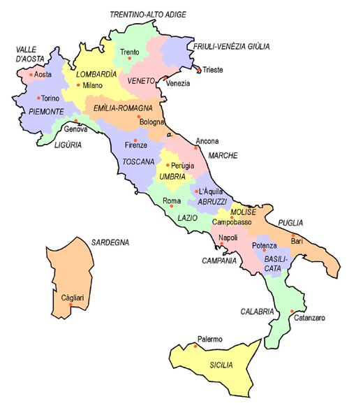
Source: Volker Preuß
Area: 8.542 square miles
Inhabitants: 4.467.000 (2019)
Density of Population: 523 inh./sq.mi.
Capital: Bologna, 390.600 inh. (2019)
official Language: Italian
other Languages: Emilian, Romagnol
Time Zone: GMT +1h
Source: Wikipedia (D)
The Region of Emìlia-Romagna was established in 1947. It includes territories of the former states Duchy of Parma, Duchy of Modena and of the Papal States (Patrimonium Petri), which dissolved in 1861 into the Kingdom of Italy.
Source: Atlas zur Geschichte,
Wikipedia (D)
The Emilia-Romagna region consists of two parts, the Emilia region in the west and the Romagna region in the east. In Emilia were placed until 1860, the two Duchies, of Parma and Modena. The Romagna belonged until 1860 to the Papal States (Patrimonium Petri). The name "Emilia" goes back to a Roman road which crossed the region, the "Via Aemilia". The name of the street was transferred to an entire landscape. The name "Romagna" goes back to the 6th century, when the Lombards described this landscape as a to Byzantium (Eastern Rome) belonging region, namely "Romania". This has its roots in the Byzantines themselves, who liked it to call themselves as Romeans, even though they spoke in Greek. So the Romania belonged to the Romeans.
Source:
Wikipedia (D), Volker Preuß

Kindly supported by: