Eritrea |
|
|
|
| Übersicht – Contents: | |
Eritrea |
|
|
|
| Übersicht – Contents: | |
Flaggen – Flags: |
|
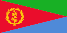 |
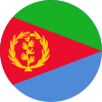
Nationalflagge – national flag, Seitenverhältnis – ratio = 1:2, Quelle/Source nach/by: Flags of the World
|
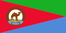 |
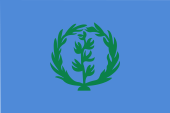
Flagge des Präsidenten – flag of the president, Seitenverhältnis – ratio = 1:2, Quelle/Source nach/by: Wikipedia (D)
|
historische Flaggen – historical Flags: |
|
 |
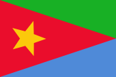
1952–1959, Nationalflagge – national flag, Seitenverhältnis – ratio = 2:3, Quelle/Source nach/by: Flags of the World
|
 |
Flagge der EPLF – flag of the EPLF, Seitenverhältnis – ratio = 2:3, Quelle/Source nach/by: Wikipedia (EN)
|
Bedeutung/Ursprung der Flagge – Meaning/Origin of the Flag: |
|
| Die Flagge Eritreas wurde am 24.05.1993 offiziell eingeführt, und zwar im Format 2:3. Am 05.12.1995 erfolgte eine Formatänderung auf 1:2. Die Flagge hat ihren Ursprung in der Flagge der 1970 gegründeten eritreischen Befreiungsfront (EPLF). Deren Flagge trug anstelle des gelben Olivenzweiges und des gelben Olivenkranzes einen gelben Stern. Sie ging aus der Flagge des autonomen Eritrea hervor, die zwischen 1952 und 1959 verwendet wurde. Die Flagge von Eritrea ist in drei Bereiche gegliedert. In der Mitte ein gleichschenkliges Dreieck in Rot, dessen Basis an der Stangenseite liegt, oben ein rechtwinkliges grünes Dreieck, unten ein rechtwinkliges blaues Dreieck. Im roten Dreieck ein gelber Olivenzweig mit gleichfarbigem Olivenkranz. Rot steht für das im Freiheitskampf vergossene Blut, Blau für den Meeresreichtum, Grün für Landwirtschaft und Fruchtbarkeit. Der Olivenkranz mit dem Olivenzweig ist ein Abbild der UNO-Weltkugel. Der UNO verdankt Eritrea seine politische Anerkennung. Als Farben für die Flagge werden angegeben: Grün = pt 361, Rot = pt 185, Blau = pt 279, Gelb = pt 123. | The flag
of Eritrea was offically introduced on the 24th of may in 1993, namely in
ratio 2:3. On 5th of December in 1995 the ratio was changed into 1:2. The
flag has its roots in the flag of the in 1970 established Erithrean
Liberation Front (EPLF). Their flag showed instead of the yellow olive-twig
and the yellow olive-garland just a yellow star. It was derived from the
flag of the autonomous Eritrea, which was in use between 1952 and 1959. The flag of Eritrea is planned in thre areas. In the middle
a red isosceles triangle, its base is on the pole, above is a orthogonal
green triangle and below a orthogonal blue triangle. In the red triangle is
placed a yellow olive-twig and a yellow olive-garland. Red stands for the in
the fight for freedom given blood, blue for the richness of the ocean and
green for agriculture and fruitfulness. The olive-twig with the
olive-garland are an image of the globe-sign of the UN. Erithrea owes the UN
its political recognition. The colours, are given for the flag: green = pt 361,
red = pt 185, blue = pt 279, yellow = pt 123. |
| Quelle/Source: Flags of the World, Flaggen-Atlas Erde | |
Wappen – Coat of Arms: |
|
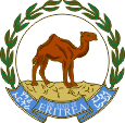 |
Wappen von Eritrea – coat of arms of Eritrea, Quelle/Source: Wikipedia (D) |
Bedeutung/Ursprung des Wappens – Meaning/Origin of the Coat of Arms: |
|
| Das Wappen von Eritrea ist nicht im eigentlichen Sinne ein Wappen, es ist vielmehr ein Siegel. Es wurde am 24.05.1993 im Zusammenhang mit der Unabhängigkeit des Landes eingeführt. Es zeigt ein stehendes Dromedar, umgeben von einem Olivenkranz. Im unteren Bereich findet sich ein blaues Schriftband mit dem Staatsnamen in weiß, in den offiziellen Landessprachen Englisch, Tigrinya und Arabisch. | The coat of arms of Eritrea is in actual fact no coat of arms, it is rather a seal. It was introduced on 24th
of May in 1993 on the occasion of the independence of the state. It shows a standing camel, surrounded by an olive wreath. In the lower part there is a blue ribbon which carries the name of the state in white, in the official languages English, Tigrinya and Arabic. |
| Quelle/Source: Wikipedia (D) | |
Flugzeugkokarde – aircraft roundel: |
|
 |
Flugzeugkokarde – aircraft roundel Quelle/Source: nach/by Wikipedia (EN) |
| Landkarten – Maps: |
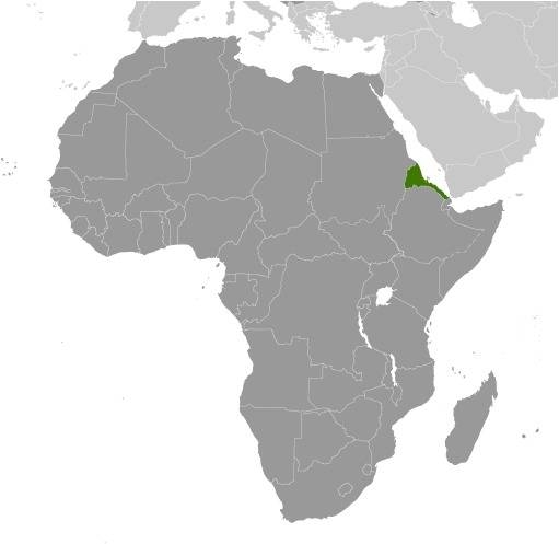
Lage – Position: |
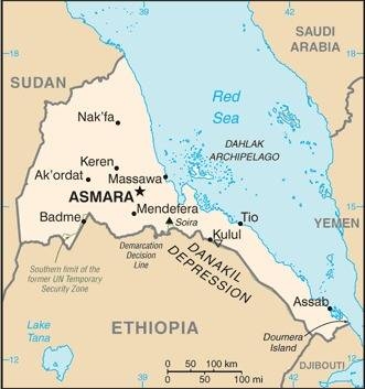
Landkarte des Landes – Map of the Country: |
Zahlen und Fakten – Numbers and Facts: |
|
|
|
|
|
|
|
|
|
|
|
|
|
|
|
|
|
|
|
|
|
|
Geschichte: |
|
ca. 5. Jhd.–12. Jhd. · zum Reich von Aksum 12. Jhd. · der Süden Eritreas kommt zum Sultanat Adal 1500 · ganz Eritrea kommt zu Adal 1517 · Besetzung der Küste durch türkische Truppen 1520 · Massaua von Portugiesen erobert 1818–1885 · Massaua gehört zu Ägypten 1882 · beginnende Kolonisierung durch Italien in und um Assab 1885 · Massaua von den Italienern erobert 1890 · Eritrea wird italienische Kolonie 1940 · Besetzung durch britische Truppen 1952 · Eritrea wird ein autonomer Staat innerhalb Äthiopiens 1961 · Beginn des bewaffneten Widerstands der EPLF 1962 · Eritrea wird äthiopische Provinz 1987 · Ablehnung der Autonomie durch die EPLF 1988 · Verstärkung des bewaffneten Widerstands der EPLF 1991 · Die EPLF erobert Asmara 1993 · Unabhängigkeit 1998–2001 · Grenzkriege mit Äthiopien 2018 · Friedensvertrag zwischen Äthiopien und Eritrea |
History: |
|
ca. 5. cent.–12. cent. · to the Aksum Empire 12. cent. · the south of Eritreas comes to the Sultanate of Adal 1500 · whole Eritrea comes to Adal 1517 · occupation of the coast by Turkish troops 1520 · Massaua captured by Portugese 1818–1885 · Massaua belongs to Egypt 1882 · beginning colonization by Italia in and around Assab 1885 · Massaua captured by the Italians 1890 · Eritrea becomes an Italian colony 1940 · occupation by British troops 1952 · Eritrea becomes an autonomous state within Ethiopia 1961 · start of the armed resistance of the EPLF 1962 · Eritrea gets an ethiopian province 1987 · dismissal of autonomy by the EPLF 1988 · strengthening of the armed resistance of the EPLF 1991 · the EPLF captures Asmara 1993 · independence 1998–2001 · frontier wars with Ethiopia 2018 · peace treaty between Ethiopia and Eritrea |
| Quelle/Source: Atlas zur Geschichte, Wikipedia (D) |
Ursprung des Landesnamens – Origin of the Country's Name: |
|
| Der Name des Landes geht auf das altgriechische Wort "erythros" zurück, was "rot" heißt, und auf die Lage des Landes am Roten Meer anspielt. | The name of the country goes back to the ancient Greek word "erythros" what "red" means, and alludes to the situation of the country on the Red Sea. |
| Quelle/Source: Handbuch der geographischen Namen | |