mobile View, to the German Version tap the flag


- Republic of Eritrea
- presidial republic
- own names:
Tigrinya: Hagere Ertra; Arabic: Iritriyyā
• Flags
• Historical Flags
• Meaning/Origin of the Flag
• Coat of Arms
• Meaning/Origin of the Coat of Arms
• Aircraft Roundel
• Map
• Numbers and Facts
• History
• Origin of the Country's Name
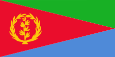
National flag,
ratio = 1:2,
Source, by:
Flags of the World


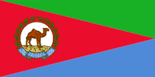
Flag of the president,
ratio = 1:2,
Source, by:
Wikipedia (D)


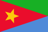
1952–1959,
National flag,
Source, by: Flags of the World

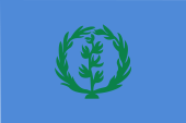
Flag of the EPLF,
Source, by:
Wikipedia (EN)
The flag of Eritrea was offically introduced on the 24th of may in 1993, namely in ratio 2:3. On 5th of December in 1995 the ratio was changed into 1:2. The flag has its roots in the flag of the in 1970 established Erithrean Liberation Front (EPLF). Their flag showed instead of the yellow olive-twig and the yellow olive-garland just a yellow star. It was derived from the flag of the autonomous Eritrea, which was in use between 1952 and 1959. The flag of Eritrea is planned in thre areas. In the middle a red isosceles triangle, its base is on the pole, above is a orthogonal green triangle and below a orthogonal blue triangle. In the red triangle is placed a yellow olive-twig and a yellow olive-garland. Red stands for the in the fight for freedom given blood, blue for the richness of the ocean and green for agriculture and fruitfulness. The olive-twig with the olive-garland are an image of the globe-sign of the UN. Erithrea owes the UN its political recognition. The colours, are given for the flag: green = pt 361, red = pt 185, blue = pt 279, yellow = pt 123.
Source:
Flags of the World,
Flaggen-Atlas Erde
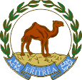
Coat of arms of Eritrea,
Source:
Wikipedia (D)
The coat of arms of Eritrea is in actual fact no coat of arms, it is rather a seal. It was introduced on 24th of May in 1993 on the occasion of the independence of the state. It shows a standing camel, surrounded by an olive wreath. In the lower part there is a blue ribbon which carries the name of the state in white, in the official languages English, Tigrinya and Arabic.
Source: Wikipedia (D)
Aircraft Roundel,
Source, by: Wikipedia (EN)
Location:
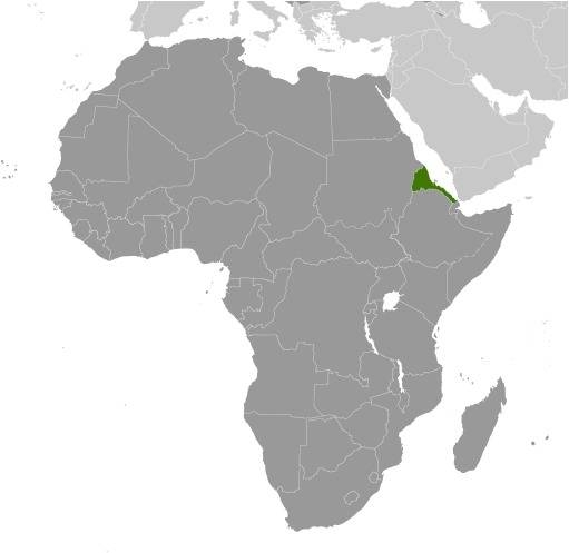
Source: CIA World Factbook
Map of the country:
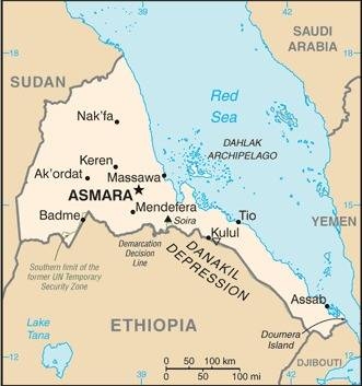
Source: CIA World Factbook
Area: 45.405 square miles
Inhabitants: 5.100.000 (2017), thereof 55% Tigrinya, 30% Tigre, 4% Saho, 2% Bilen
Religions: 50% Muslim, 48% Christian
Density of Population: 112 inh./sq.mi.
Capital: Asmara (Asmera), 896.000 inh. (2018)
official Language: Tigrinya, Arabic
other Languages: English, Tigre, Afar, Saho, Kunama, Bedsha, Blin, Nara
Currency: Nakfa (ERN) = 100 Cent
Time Zone: GMT + 3 h
Source: Wikipedia (D)
ca. 5. cent.–12. cent. · to the Aksum Empire
12. cent. · the south of Eritreas comes to the Sultanate of Adal
1500 · whole Eritrea comes to Adal
1517 · occupation of the coast by Turkish troops
1520 · Massaua captured by Portugese
1818–1885 · Massaua belongs to Egypt
1882 · beginning colonization by Italia in and around Assab
1885 · Massaua captured by the Italians
1890 · Eritrea becomes an Italian colony
1940 · occupation by British troops
1952 · Eritrea becomes an autonomous state within Ethiopia
1961 · start of the armed resistance of the EPLF
1962 · Eritrea gets an ethiopian province
1987 · dismissal of autonomy by the EPLF
1988 · strengthening of the armed resistance of the EPLF
1991 · the EPLF captures Asmara
1993 · independence
1998–2001 · frontier wars with Ethiopia
2018 · peace treaty between Ethiopia and Eritrea
Source:
Atlas zur Geschichte,
Wikipedia (D)
The name of the country goes back to the ancient Greek word "erythros" what "red" means, and alludes to the situation of the country on the Red Sea.
Source:
Handbuch der geographischen Namen
