mobile View, to the German Version tap the flag


- Tuamotu Islands (Îles Tuamotu), also: Tuamotu Archipelago
- possession of France
- part of the French possession of French Polynesia
- own name: Subdivision administrative des Archipel des Tuamotu
- other names: - Paumotu Islands - Dangerous Islands - Low Archipel
• Flags
• unofficial Flag
• historical Flag
• Meaning/Origin of the Flag
• Map
• Numbers and Facts
• History
• Origin of the Country's Name

Flag of France,
ratio = 2:3,
Source, by: Corel Draw 4


since 1984,
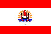
Flag of French Polynesia,
ratio = 2:3,
Source, by: Wikipedia (D)

since 1984,
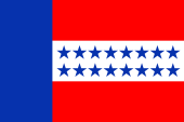
unofficial Flag,
ratio = 2:3,
Source, by: Wikipedia (D)

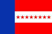
1832-1843,
Flag of the Kingdom of Tuamotu,
ratio = 2:3,
Source, by: FOTW
The Tuamotu Islands – as a part of French Polynesia – have officially no own flag. It must be hoisted the French tricolor or additionally, the flag of French Polynesia. However, there exists for local purposes an unofficial flag. It shows three horizontal stripes in red, white and red (ratio: 1:1:1) and a blue vertical stripe at the leech. In the white stripe are placed two rows of eight blue five-pointed stars. They stand for the sixteen municipalities of the archipelago. The flag remembers the flag of the Kingdom of Tuamotu, which existed between 1832 and 1843. The colour sequence of red, white and red remembers Tahiti and French Polynesia. The colours blue, white and red are the colors of France, and the blue also represents the sky and the sea. The colour red is defined as Pantone 185c, and the colour blue as Pantone 286c.
Source: Wikipedia (D),
FOTW
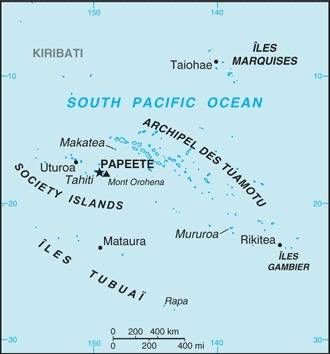
Location:
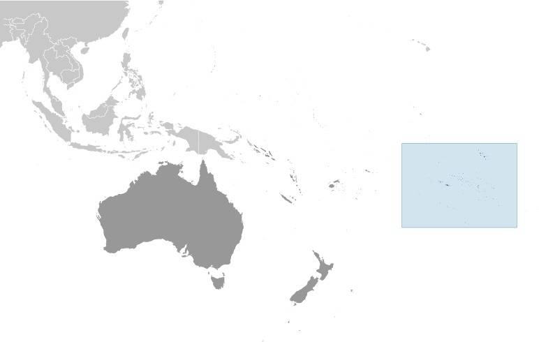
Source: CIA World Factbook
Map of French Polynesia:
Source: CIA World Factbook
Map of the Islands:

Landkarte/map, Source: Makemake at the German language Wikipedia
[GFDL or CC-BY-SA-3.0], via Wikimedia Commons,
click to enlarge
Subdivisions of French Polynesia:

Landkarte/map, Source: By L. Claudel (Sardon - fr:Sardon)
[GFDL or CC BY-SA 3.0], via Wikimedia Commons,
click to enlarge
Area: 328 square miles
Inhabitants: 15.350 (2017)
Density of Population: 47 inh./sq.mi.
Main place (Main island): Rangiroa, 2.709 inh. (2017)
official Language: French
other Languages: Tuamotuan (Polynesian dialect)
Currency: CFP-Franc (CFPF) = 100 Centimes,
CFPF = "Franc des Colonies Françaises du Pacifique"
Time Zone: GMT – 10 h
Source: Wikipedia (EN)
ca. 500 B.C. · beginning polynesian settlement
1521 · the Portugese seafarer Ferdinand Magellan discoveres the islands and visits Puka Puka and probably Fakahina and Fangatau too
1606 · the Spanish seafarer Pedro Fernández de Queirós travels through the archipelago
1616 · The Dutch seafarers Schouten and Le Maire travel through the archipelago
1722 · The Dutch seafarer Jacob Roggeveen travels through the archipelago
1765 · the British seafarers John Byron travels through the archipelago
1767 · the British seafarer Samuel Wallis travels through the archipelago, in the following years the from Tahiti coming Pomaré Dynasty can prevail – supported by Great Britain – even on the Tuamotu Islands
1768 · the French seafarer Louis Antoine de Bougainville travels through the archipelago and names it "Dangerous Islands"
1769 · the British seafarer James Cook travels through the archipelago
1815 · the Russian seafarer Otto von Kotzebue travels through the archipelago
1818 · the islands become a French sphere of influence
1832–1843 · Kingdom of Tuamotu
1844 · France declares the Tuamotu Islands to a French Protectorate
1880 · France annexes Tahiti and also the Tuamotu Islands, they become a French colony
1903 · establishing of a unified French colonial administration for the Society Islands, Marquesas Islands, Tuamotu Islands, Gambier Islands and Austral Islands under the name "French Polynesia"
1966 · first French nuclear tests on the Mururoa and Fangataufa Islands
1996 · after 181 nuclear tests France ends the tests in the region
Source: Wikipedia (D)
The today's Tuamoutu Archipelago had already many names, and some of them can still be found in some old atlases. The most famous is likely the designation "Paumotu Archipelago", but also "Low Isles" is known, "Dangerous Islands" probably less. As in 1616, the Dutchman Willem Schouten sailed through the archipelago, he named the area "Evil Sea". His compatriot Jacob Roggeveen travels in 1722 through the archipelago, and named it "Labyrinth". The Russian officer Adam Johann von Krusenstern, who probably visited this part of the world in 1767 under Commander Samuel Wallis, named the archipelago "Low Isles" (Low Archipel). One year later, the French navigator Louis Antoine de Bougainville travels through the archipelago, and named it "Dangerous Islands". "Toamotu" is a Polynesian word, composed of the words "tua" (far) and "motu" (island), and it can be translated with "Far Islands". "Paumotu" is also a Polynesian word, but composed of the words "pau" (end) and "motu" (island), and it can be translated with "Islands on the End".
Source:
Meyers Konversationslexikon, Atlas der wahren Namen
