mobile View, to the German Version tap the flag


- former Kingdom in Southern England
- historic County of England
- own name: Cantaware Rīce
• Introduction
• History
• Flag
• Meaning/Origin of the Flag
• Map
Britannia was conquered by Roman legions around the year 43 and became in 85 a province of the Roman Empire. Towards the end of the fourth century the Roman Empire came under considerable pressure from outside, so that Britannia could no longer be held. Thus the Romans began to withdraw about 400 or 410. Shortly afterwards, Jutes and Angles began to migrate in eastern and southern Britannia coming from today's Denmark and Saxons coming from the area of the Weser and Elbe estuaries, and also some Frisians. The differences between the peoples blurred over the generations, and they were summarized under the term Anglo-Saxons. As fighters they have been very welcome for the mostly Romanesque Celtic British, against the since the withdraw of the Romans advancing Picts and Scots. Already in the middle of the fifth century, they had established themselves as the new aristocracy and began to separate from themselves by the formation of their own kingdoms.
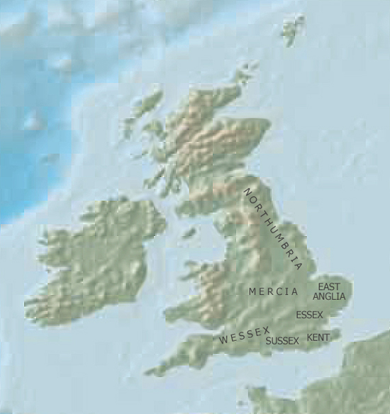
Since the beginning of the 6th century, seven great kings have been known which dominated the south and east of Britannia. A formation of states that has become known in history as "Heptarchy" (Greek: hepta = seven). These have been the kingdoms of Sussex, Wessex, Essex, Kent, East Anglia, Mercia and Northumbria. However, in reality, there have been more and some smaller kingdoms, which, however, often existed for only a short time. In 825 Wessex, Sussex, Kent and Mercia became united under King Egbert of Wessex. Essex, East Anglia and parts of Mercia were occupied by invading Danes in the year 865 and became summarized as "Danelaw" (Danelag, territory of Danish law). In 1016 the Danish Knut the Great (brother of the king of Denmark) forced his election to the first king of England. After riots the Danish rule ended in 1050, and in 1066 Harald II., Earl of Wessex, was crowned to the first Anglo-Saxon King of England.
Source: Wikipedia (D)

The Kingdom of Kent was first mentioned in 449, by the legendary founding of the state by Hengest. It is a foundation of the Jutes, and was placed in the south-east of Britannia. The name of the country, however, goes back to the Celtic tribe of the Cantwari, who lived here when the Jutes came into the country. At the end of the 7th century Kent came under the alternating influence of the kingdoms of Wessex and Essex for several years. In the year 725, the kingdom became divided between two heirs, and Eastern Kent and Western Kent came into being. At the beginning of the 8th century Western Kent came under the influence of the Kingdom of Mercia, from the middle of the 8th century even Eastern Kent. In the Battle of Otford in 776 the kingdoms of Kent could free themselves again, but they were taken over again by Mercia in 785. However, Mercia was defeated in the Battle of Ellandun by Wessex in 825, so that Kent came under the rule of Wessex as a Viceroyalty, and it became completely annexed by Wessex in about 890, and shortly afterwards it became a county of England.
Source: Wikipedia (D)

Flag of Kent,
ratio = 3:5,
Source, by: Wikipedia (EN)


The time of the Heptarchy belongs – in the themes of flags or coats of arms – to the period of protoheraldics. This means that seals, coats of arms or flags, as we know them today, were not yet in use. Nevertheless, it seems that there was a kind of symbolism, which is partly handed down, or it is known from the field of legends. The coats of arms or flags were designed in the modern age, which are used now for the ancient kingdoms of the Heptarchy.
The heraldry of Kent, which is known today, shows a rising white horse, a stallion, on red. Its origin is legend. Supposedly it goes back to Horsa the Jute, the brother of Hengest, who founded the Kingdom of Kent in 449. A coat of arms with this heraldry was first mentioned in 1605.
Source: Wikipedia (EN), Volker Preuß
Source: Freeware, University of Texas Libraries, modyfied by: Volker Preuß
