Ionische Inseln |
|
|
|
| Übersicht – Contents: | |
Ionische Inseln |
|
|
|
| Übersicht – Contents: | |
Flaggen – Flags: |
|
 |
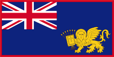
1800–1815, Flagge der Ionischen Inseln – flag of the Ionian Islands, Quelle/Source, nach/by: Wikipedia (EN), Bild/picture by: By Orange Tuesday [Public domain], via Wikimedia Commons
|
 |
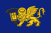
1815–1863, Flagge der Ionischen Inseln – flag of the Ionian Islands, Quelle/Source, nach/by: Wikipedia (EN), Bild/picture by: By Orange Tuesday [Public domain], via Wikimedia Commons
|
Bedeutung/Ursprung der Flagge – Meaning/Origin of the Flag: |
|
| Die Flagge der Ionischen Inseln enthält Elemente, die auf die früheren Herren der Insel verweisen. So ist in der Oberecke der britische Union Jack zu sehen, und ferner der Löwe von San Marco, der an die venzianische Herrschaft erinnert. Die Flagge hat ihre Wurzeln in der Flagge der Republik der Ionischen Inseln, einem Staat der von 1800 bis 1807 kurzzeitig unter russischer Oberhoheit existiert hat. | The flag of the Ionian Islands contains elements which point to the former rulers of the islands. The upper quadrant shows the British Union Jack and the field the Lion of San Marco, reminders of the rule of Venice. The flag has its roots in the flag of the Republic of the Ionian Islands, a state that existed here from 1800 to 1807 for a short time under Russian sovereignty. |
| Quelle/Source: Volker Preuß | |
Landkarte – Map: |
Lage – Position: |
Zahlen und Fakten – Numbers and Facts: |
|
|
|
|
|
|
|
|
|
|
|
|
|
|
|
|
|
|
|
|
![]()
Geschichte: |
|
700–27 v.Chr. · die Ionischen Inseln gehören zu
Griechenland 228 v.Chr. · Korfu wird römische Einflusssphäre 27 v.Chr. · die restlichen Inseln kommen zum Römischen Reich 395 · bei der Teilung des Römischen Reiches kommen die Inseln an das Oströmische Reich (Byzanz) 1206–1209 · Eroberung der Ionischen Inseln durch Venedig 1467–1500 · Eroberung der Ionischen Inseln durch das Osmanische Reich (außer Korfu und Kythera) 1797–1799 · Besetzung durch Frankreich 1799–1807 · Besitz Russlands 1807–1814 · Besitz Frankreichs 1814–1864 · im Besitz von Großbritannien 1864 · zu Griechenland |
History: |
|
700–27 B.C. · the Ionian Islands belong to Greece 228 B.C. · Corfu becomes a Roman zone of influence 27 B.C. · the remaining islands come to the Roman Empire 395 · at the partition of the Roman Empire the islands come to the East Roman Empire (Byzantium) 1206–1209 · conquest of the Ionian Islands by Venice 1467–1500 · conquest of the Ionian Islands by the Ottoman Empire (except Corfu and Kithera) 1797–1799 · occupation by France 1799–1807 · possession of Russia 1807–1814 · possession of France 1814–1864 · possession of United Kingdom 1864 · to Greece |
| Quelle/Source: Atlas zur Geschichte, Wikipedia (EN), Discovery '97 |
Ursprung des Landesnamens – Origin of the Country's Name: |
|
| Die Ionischen Inseln haben ihren Namen vom Ionischen Meer her, an dessen östlichem Rand sie liegen. Das ionische Meer ist ein Teil des Mittelmeeres und liegt zwischen Griechenland, der Südküste von Albanien, Kalabrien, Apulien und Sizilien. Das Meer hat seinen Namen schon in der Antike erhalten, allerdings wurde damals damit das heutige Adriatische Meer bezeichnet. Benannt wurde es nach Io, der Tochter des griechischen Flussgottes Inachos, Geliebte des Zeus und Mutter des Epaphos. Der Name des Meeres bzw. der Inseln hat nichts mit dem berühmten antiken Volk der Ionier zu tun. Die siedelten in der Frühzeit zwar an der Nordküste des Peloponnes, wurden aber von den Herakleiden und Dorern nach Attika abgedrängt und von dort weiter nach der Westküste Kleinasiens, die daher den Namen Ionien trägt. | The Ionian Islands have their name from the Ionian Sea, on the eastern edge of which they lie. The Ionian Sea is
a part of the Mediterranean Sea and lies between Greece, the south coast of Albania, Calabria, Apulia and Sicily. The sea has been given its name in ancient times, but it
this way has been called then the today's Adriatic Sea. It was named after Io, the daughter of the Greek river-god Inachus, was one beloved of Zeus and is the mother of Epaphus. The name of the sea or the islands has nothing to do with the famous ancient people of the Ionians. They settled in the early days on the northern coast of the Peloponnese, but were expelled from the Heracleidae and Dorians to Attica and from there on to the western coast of Asia Minor, which therefore bears the name Ionia. |
| Quelle/Source: 1) Wikipedia (DE, 2) Wikipedia (DE, 3) Pierer's Universal-Lexikon, 4) Pierer's Universal-Lexikon | |

