mobile View, to the German Version tap the flag


- Yamal-Nenets Autonomous Okrug
- also: Yamalo-Nenetsia, Yamalia
- federal component of the Russian Federation (Russia)
- own name: Yamalo-Nenetski awtonomny okrug
• Flag
• Meaning/Origin of the Flag
• Coat of Arms
• Map
• Numbers and Facts
• History
• Origin of the Country's Name

National flag,
ratio = 2:3,
Source, by: Flags of the World, Russiatrek


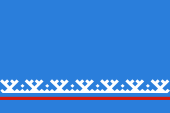
The flag of the Yamal-Nenets Autonomous Okrug shows a plain blue bunting with a continuous narrow red stripe and a native folklore motif, a white border made of Tyumen Crowns. The flag was officially adopted on 28th of November in 1996.
Source: Wikipedia (EN)


Coat of arms of Yamalo-Nenetsia,
Source: Russiatrek

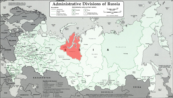
geographical position within Russia:

Source: Freeware, russiamap.org, modyfied by: Volker Preuß
enlarge – click or tap here
Map of the country:

Map of Yamalo-Nenets Autonomous Okrug

Area: 297.007 square miles
Inhabitants: 522.900 (2010), thereof 59 % Russians, 9 % Ukrainians, 6 % Nenets, 5 % Tatars
Density of Population: 1,67 inh./sq.mi.
Capital: Salechard (to 1933 Obdorsk), 42.544 inh. (2010)
official Languages: Russian, Nenets language (Yurak language)
Currency: Russian Currency
Time Zone: GMT + 5 h
Source: Wikipedia (DE)

1553–1598 · Russian colonization
1922 · establishment of the Soviet dictatorship
7th of October 1977 · establishment of the National District of the Yamal-Nenzes
31st of December in 1991 · the Soviet Union dissolves, the constitution of the Russian Socialist Federative Soviet Republic (RSFSR, Russia), a former substate of the Soviet Union, remains in force for the time being
25th of December in 1993 · a new constitution for Russia (Russian Federation) comes into force, and the relationships with the members of the federation is re-regulated in this way
Source: Atlas zur Geschichte,
World Statesmen,
Wikipedia (D)

The name of the country, the Yamal-Nenets Autonomous Okrug (district), goes back to the Nenets people, who live here, mainly on the Yamal Peninsula. It is about 44.000 sq.mi. in size and is located northeast of the northern end of the Ural Mountains and extends west of the mouth of the Ob River into the Kara Sea. The Nenets were formerly called "Samoyed", which means "self-eater". To avoid this disrespectful name, this name has been less and less used during the 20th century and instead of it the term "Nenets" from the language of this people was used, which means "people". Another common name for the Nenets was "Yurak". The Nenetian word "Yamal" means "end of the land".
Source:
1. Wikipedia (DE),
2. Wikipedia (DE),
Pierer's Universal-Lexikon

Surftipp:


![]()


