mobile View, to the German Version tap the flag


- historic: Ryukyu Islands
- Japanese Archipelago and Prefecture
- zone of US-american influence
- own names:
· Japanese: Okinawa
· Okinawan: Uchina
• Flag
• Historical Flags
• Meaning/Origin of the Flag
• Map
• Numbers and Facts
• History
• Origin of the Country's Name
Geographic Terms: The term "Okinawa" is the name of the largest island in an archipelago that lies between Japan and Taiwan. In Japanese, this archipelago is called "Nansei-Shoto". On these islands formed from the 12th century a state, the Kingdom of Ryukyu, and in this way the name Ryukyu was transferred to the entire archipelago, known until today (outside of Japan) as Ryukyu Islands. When the Japanese government in 1879 finally brought the islands into his possession, on the Ryukyu Islands was established the Okinawa Prefecture, named after the largest island. The islands were occupied during World War II by U.S. forces, instead of Japan , an U.S. military administration was established and there were built military bases. The Amami Islands were returned to Japan in 1953 and became connected to the Kagoshima Prefecture.

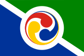
Flag of the Prefecture of Okinawa,
ratio = 2:3,
Source, by: Wikipedia (EN)


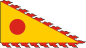
19th century,
Merchant flag of the Ryukyu Kingdom,
(?) Source, by:
Flags of the World
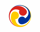
to 1875,
Flag of the Ryukyu Kingdom,
Source, by:
Wikipedia (EN)
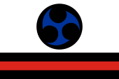
1875–1879,
Flag of the Ryukyu Kingdom,
Source, by:
Flags of the World
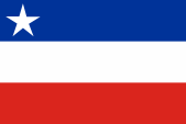
1950,
Flag of the purposed Independent State of Okinawa,
ratio = 2:3,
Source, by:
Flags of the World
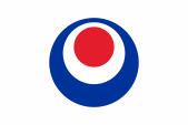
1950–1967,
Ship flag,
Source, by:
Wikipedia (EN)
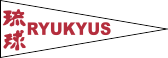
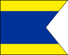
1967–1972,
Additional pennant to the Japanese flag,
Source, by:
Wikipedia (EN)
Flag of the Ryukyu Independent Party
(Kariyushi Club),
ratio = 2:3,
Source, by:
Flags of the World
Flag of the Okinawa Independence Party,
ratio = 2:3,
Source, by:
Flags of the World
Unofficial flag of Okinawa,
Source, by:
Flags of the World
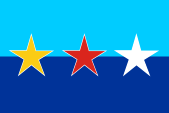
The Official Flag of the Okinawa Prefecture was introduced in 1972. It shows a white bunting with a typical Japanese piktogram in the center, which is formed by concentric dark red circles, shifted slightly upward. Supposedly the picture represents the letter "O", the first letter of the country's name. The inner red circle should represent Okinawa itself, the outer red circle the sea, which surrounds the islands. Because the history Okinawa of begins as Kingdom of Ryukyu, here of course existed own flags before. The first in the early 19th century mentioned flag was a triangular yellow flag with a red disc in the middle, which showed little red spikes on its edges. It was allegedly used by merchant ships, which aimed Chinese ports. The Ryukyu Kingdom was claimed by China until the 19th century, and there were even paid tributes to China. Thus, the Chinese design of this flag is to be explained. With the gradual suppression of the Chinese influence and the growing Japanese influence, the flags of the Kingdom of Ryukyu became white in the 19th century and they showed a round symbol of three intertwined elements, which was shown in color from 1875. With the overthrow of the king by Japan and the annexation of the country to the Japanese state the history of the flags of Ryukyu ended. After the Second World War and the occupation by U.S. troops, on the Ryukyu Islands appeared efforts to revive their own state, and in January 1950 was proposed a three striped flag in the colors blue, white and red, and in the blue stripe - close to the mast - was showed a white star. These ambitions were, however, only supported by the USA until March 1950. The flag was not well received by the population and was never introduced. As the islands were subordinated under the U.S. military administration, and belonged no longer to Japan, there had its own flag to be introduced, needed mainly for the coastal shipping, to mark the native vessels. They chose a to a dovetail cuted variant of the flag "D" out of the international alphabet of signal flags. The use of the Japanese flag was banned. From 1967 it was allowed to use the Japanese flag again, but until 1972 added by a small white pennant with the word "Ryukyu" in red, Japanese and Latin inscription. Due to the special history and culture of the islands and the in the past practiced aggressive Japanese policy, there are still exist efforts to revive the State of Ryukyu. These ideas are supported by about 25% of the population. These parts of the population love it to show a nearly similar variant of the flag of Okinawa Prefecture, which shows the colors blue, white and red. This flag is of great importance in martial arts (Okinawa is believed to be the birthplace of Karate), and the triad of blue, white, and red is said to predate the current prefectural flag. That dates from 1972 and is said to be based on the Japanese flag and thus stands for the period of suppression of Ryukyu/Okinawa culture and language. The prefecture is said to have tried to adopt the blue, white and red flag as the prefectural symbol, but a martial arts organization threatened to sue. Also interesting are the flags of the Okinawa Independence Party and of the Kariyushi Club who called himself until 2008 Ryukyu Independent Party.
Source:
Flags of the World,
Wikipedia (EN),
Volker Preuß
Location:
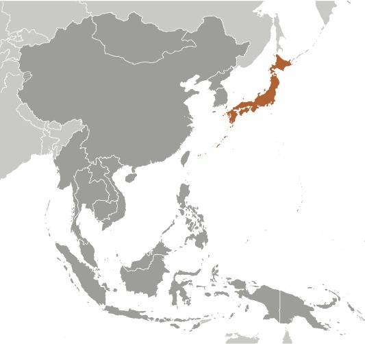
Source: CIA World Factbook
Map of the country:
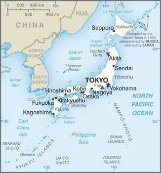
Source: CIA World Factbook
Map of the Ryukyu Islands:
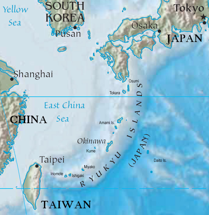
Source: Freeware, University of Texas Libraries, modyfied by: Volker Preuß
Area: 878 square miles, including the islands of: Okinawa, Kume, Iotorishima, Mixako, the Yaeyama Islands (Ishigaki and Iriomote), the Daito Islands and the Senkaku Islands
Inhabitants: 1.460.652 (2021)
Density of Population: 1.662 inh./sq.mi.
Capital: Naha, 317.405 inh. (2019)
official Language: Japanese
other Languages: Okinawan
Currency: Japanese currency: 1 Yen (JPY, ¥) = 100 Sen
Time Zone: GMT + 9 h
Source:
Wikipedia (D),
Stanisław Meyer
about 30000 B.C. · settlement by the Yamashita-cavemen
from 2000 B.C. to 12th century A.D. · development of two cultures, formation of principalities, contacts to Japan
12th century · unification of some principalities under Shunten Aji
14th century · reign of King Satto, contacts to Korea, Japan and China
1372-1439 · reign of King Sho Hashi, complete unification of the Kingdom of Ryukyu, establishing of the Sho-Dynasty
1477-1526 · reign of King Sho Shin, disempowerment of local rulers, establishment of a central government, pay of tributes to China
1609 · Satsuma-Invasion by Japan, Ryukyu becomes also dependent on Japan, the Anami Islands become ceded
1853 · The U.S. sailor Matthew Perry builts a coal station in Okinawa
1871 · Japan took over the administration, annexation of the Ryukyu Islands to the Kagoshima Prefecture
1874 · Taiwan-Expedition of Japan, China recognizes the Japanese sovereignty over the Ryukyu Islands
1878 · the Emperor of the German Empire, Wilhelm I., erects a monument on Miyako Island
1879 · dethronement of the King by Japan, establish of the Okinawa Prefecture, cede of the Yaeyama Islands (Ishigaki and Iriomote) and of Miyako Island to China
1894–1895 · Japanese victory in the Sino-Japanese War, Yaeyama and Miyako become affiliated to the Okinawa Prefecture
April–June 1945 · Battle of Okinawa during World War II, invasion of U.S. troops, all Ryukyu Islands south of the 29th latitude become occupied by U.S. troops and subordinated under a military administration, establishment of U.S. military bases
8th of September in 1951 · Treaty of San Francisco, Japan regains his self-determination, regulation of the status of the Ryukyu Islands
1953 · return of the Amami Islands to Japan, annexation to the Kagoshima prefecture
1972 · return of Okinawa from USA to Japan, the U.S. bases remain until today (at about 15% of the area of the island of Okinawa)
Source: Wikipedia (D)
The word "Okinawa" is composed of the elements "Oki" and "Nawa". These two Japanese words mean "open sea" and "chain", and describe in this way the arrangement and location of the islands.
Source:
Handbuch der geographischen Namen
kindly supported by: Maria Gürth and Stanisław Meyer
