mobile View, to the German Version tap the flag


- Autonomous Republic of Kalmykia
- federal component of the Russian Federation (Russia)
- own name: Hal'mg-Tangdsh
• Flag
• Historical Flags
• Meaning/Origin of the Flag
• Coat of Arms
• Map
• Numbers and Facts
• History
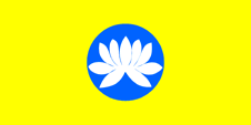
National flag,
ratio = 1:2,
Source, by: Flaggen Enzyklopädie


1938–1943,
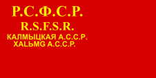
Flag of the autonomous soviet republic,
ratio = 1:2,
Source, by: World Statesmen
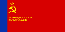
1958–1991,
Flag of the autonomous soviet republic,
ratio = 1:2,
Source, by: World Statesmen
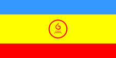
1992–1993,
National flag,
ratio = 1:2,
Source, by: Wikipedia (EN)
look also:
Flag history of the soviet republics of the USSR
The flag was adopted on 30th of July in 1992, in the format-ratio of 1:2. It is a single-coloured yellow bunting, in the middle of it is placed the Kalmyk state symbol. This is a white lotus blossom on a blue disk. The flower stands for purity, rebirth and happiness. The colour yellow is a reference to the sun, it stands for the people and the Buddhist state religion. Blue is the historical color of the Mongols. The flags, which were used in the Soviet era corresponded all to the same pattern as it was intended for the Soviet Autonomous Republics: Between 1923 and 1937 frequently only a single-coloured red bunting with a golden inscription, showing the name of the country. Sometimes only as a shortcut, sometimes the full name, sometimes only in Russian or even multilingual. From about 1937 hammer, sickle and star were sometimes added. From about the mid-50s multicolored flags were introduced for the republics of the Soviet Union, whose knitting patterns had to be taken over by the subordinated autonomous Soviet republics.
Source:
Volker Preuß, Flaggen Enzyklopädie
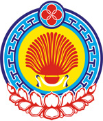
Coat of arms of Kalmykia,
Source: Russiatrek
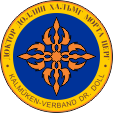
Badge of Kalmyks in the German Wehrmacht,
Source: Avantgarde für Europa
geographical position within Russi:
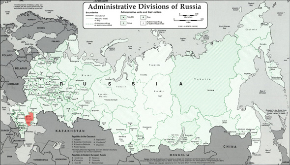
Source: Freeware, russiamap.org, modyfied by: Volker Preuß
enlarge – click or tap here
Map of the country:
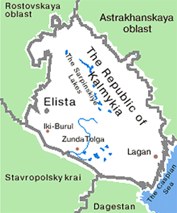
Source: Russiatrek
Area: 28.854 square miles
Inhabitants: 289.500 (2010), thereof 57% Kalmyks, 30% Russians
Density of Population: 10 inh./sq.mi.
Capital: Elista (1944–1957 Stepnoj), 104.000 inh. (2010)
official Languages: Kalmykian, Russian
Currency: Russian currency
Time Zone (to 28th of March 2010): MEZ + 4 h
Time Zone (from 28th of March 2010): MEZ + 3 h
Source: Wikipedia (DE)
1420 · disintegration of the Empire of the Golden Horde in several particular Khanates (e.g. Khanate of Astrakhan, Khanate of Sibir, Khanate of Crimea, Khanate of Casan), the area of the today's Kalmykia belongs to the Khanate of Astrakhan and is still settled by Tatars, the leftovers of the Golden Horde
1556 · conquest of the Khanate of Astrakhan by Russia
ca. 1600 · cossack armies (Terek Cossacks) range the today's Kalmykia to secure the Russian frontier in the south
1630 · the Kalmyks immigrate into their today's settlement region – they came originally from the western Mongolia
1771 · the largest part of the Kalmyks (Torguts) recurs under great losses probably under pressure of the cossacks back to Eastern Turkestan / Mongolia
1920 · establishment of the Soviet Dictatorship, establishment of the Autonomous District (Oblast) of the Kalmyks
1936 · transformation of the Autonomous District (Oblast) of the Kalmyks into the Kalmykian Autonomous Socialistic Soviet Republic
1943–1944 · deportation of the Kalmyks to Sibiria
1957 · return of the survivors
31st of December in 1991 · the Soviet Union dissolves, the constitution of the Russian Socialist Federative Soviet Republic (RSFSR, Russia), a former substate of the Soviet Union, remains in force for the time being
1992 · proclamation of the Autonomous Republic of Kalmykia
25th of December in 1993 · a new constitution for Russia (Russian Federation) comes into force, and the relationships with the members of the federation is re-regulated in this way
Source:
Atlas zur Geschichte,
World Statesmen,
Russiatrek,
Die Völker der Erde,
Discovery '97,
Wikipedia (D)
Surftip: