Labrador |
|
|
|
| Übersicht – Contents: | |
Labrador |
|
|
|
| Übersicht – Contents: | |
Flagge – Flag: |
|
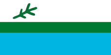 |
Flagge von Labrador |
Bedeutung/Ursprung der Flagge – Meaning/Origin of the Flag: |
|
| Die Flagge von Labrador wurde am 01.04.1974 eingeführt und zeigt drei waagerechte Streifen in Weiß, Grün und Blau, im Verhältnis 2:1:2, und einen Schwarzfichtenzweig in der Oberecke. | The flag of Labrador was introduced on 1st of April in 1974 and shows three horizontal stripes in white, green and blue, in a ratio of 2:1:2, and a black spruce branch in the upper canton. |
| Die obere weiße Streifen steht für den Schnee, der schmale, grüne Mittelstreifen steht für das während der kurzen Sommer fruchtbare Land, der untere blaue Streifen steht für das Wasser als Lebensgrundlage und wichtigster Transportweg. | The upper white stripe stands for the snow, the narrow, green middle-stripe stands for the fertile land during the short summers, the lower blue stripe stands for the water as a livelihood and the most important transport route. |
| Der Zweig der Schwarzfichte geht auf die französischsprachigen Bewohner des Landes zurück, steht hier aber für alle Bewohner, Innu, Innuit und Europäer. Die Schwarzfichte ist der häufigste Baum in Labrador. | The branch of the black spruce goes back to the French-speaking inhabitants of the country, but stands here for all residents, Innu, Innuit and Europeans. The black spruce is the most common tree in Labrador. |
| Quelle/Source: Wikipedia (EN) | |
Landkarten – Maps: |
|
|
|
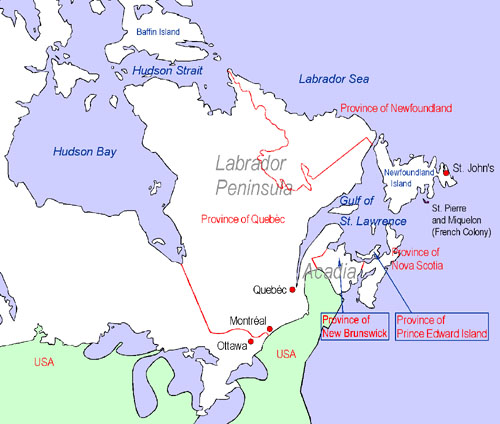
Landkarte zur Lage der Halbinsel Labrador: Map to illustrate the Position of the Labrador Peninsula: |
|
 |
| Landkarte/Map: Volker Preuß |
Zahlen und Fakten – Numbers and Facts: |
|
|
|
|
|
|
|
|
|
|
|
|
|
|
|
|
|
Geschichte: |
| ca. 1000
· Normannen entdecken das heutige Labrador 1497 · Giovanni Caboto (John Cabot), ein italienischer Seefahrer in Diensten Englands entdeckt Labrador, Neufundland und Kap Breton 16. Jhd. · England, Portugal und Spanien nehmen Fischereirechte wahr und errichten vorübergehend Fischereistützpunkte, Portugiesen geben der Halbinsel ihren Namen 1670 · englische Pelzhändler gründen die Hudson's Bay Company (HBC), die HBC kolonisiert in der Folgezeit ganz Kanada zwischen Neufrankreich den Rocky Mountains, Labrador und dem Nordrand der Hudson-Bucht 1771 · erste Ansiedlung von Europäern 1869 · die Hudson's Bay Company (HBC) überträgt alle ihre territorialen und Hoheitsrechte an das britische Dominion Kanada 1895 · Bildung des Ungava-Territoriums auf der Halbinsel Labrador 1912 · das Ungava-Territorium wird an Québec angeschlossen 1927 · Neufundland wird durch Anschluss von Teilen des nun zu Quebéc gehörenden Ungava-Territoriums nach Westen vergrößert |
History: |
| ca. 1000
· Normans discover the today's Labrador 1497 · Giovanni Caboto (John Cabot), an Italian seafarer in the services of England discovers Labrador, Newfoundland and Cape Breton 16th cent. · England, Portugal and Spain exercise fishing rights and establish momentaryly fishery bases, the Portugese give the peninsula its name 1670 · English furriers establish the Hudson's Bay Company (HBC), the HBC colonizes in the afteryears whole Canada between New France, the Rocky Mountains, Labrador and the northern rand of the Hudson Bay 1771 · first settlement by Europeans 1869 · the Hudson's Bay Company (HBC) cedes all their territorial rights and prerogatives to the British Dominion of Canada 1895 · establishment of the Ungava Territory on the Labrador Peninsula 1912 · the Ungava Territory becomes annexed to Québec 1927 · Newfoundland gets enlarged westward by annexion of parts of the now to Quebéc belonging former Ungava Territory (Labrador Peninsula) |
| Quelle/Source: Atlas zur Geschichte, Wikipedia (D), Discovery '97 |
Ursprung des Landesnamens – Origin of the Country's Name: |
|
| Der Name der Landschaft geht auf den potugiesischen Seefahrer João Vaz Corte-Real zurück, der das Land aus heute nicht mehr nachvollziehbaren Gründen "Terra dos lavradores" genannt hat. Das heißt übersetzt: "Land der Bauern". | The name of the landscape goes back to the Potugiese navigator João Vaz Corte-Real, who called the country "Terra dos lavradores " for reasons that are today not comprehensible no more. That name is to translate as: "Land of the peasants". |
| Quelle/Source: Handbuch der geographischen Namen | |