mobile View, to the German Version tap the flag


- Canadian Territory
- own names:
– English: Yukon (Territory)
– French: (Territoire du) Yukon
- native Indian own name: Kwichpak
• Flag
• Historical Flags
• Meaning/Origin of the Flag
• Coat of Arms
• Meaning/Origin of the Coat of Arms
• Map
• Numbers and Facts
• History
• Origin of the Country's Name
Flag of the Yukon Territory,
ratio = 1:2,
Source, by: Wikipedia (D)


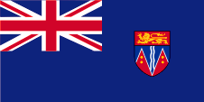
1934–1956,
Flag of the government (state flag),
ratio = 1:2,
Source, by:
World Statesmen

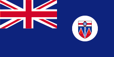
1956–1967,
Flag of the government (state flag),
ratio = 1:2,
Source, by:
World Statesmen,
Wikipedia (D)
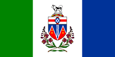
The today's flag of the Yukon Territory was introduced on 1st of December in 1967 and shows three vertical stripes in green, white and blue. The white stripe carrys in the middle the coat of arms of the territory. The green stands for the woods, the white for ice and snow and the blue for the waters. The Yukon Territory was founded in 1898 by outsourcing from the Northwest Territories. Until the year 1922 there had officially been used, the British Union Jack, the so-called Royal Union Flag, by the departments of the territories , or (from 1922 nearly only) the Canadian blue official flag, the typical British Blue Ensign, with the coat of arms of Canada in the flying end. It is believed that in the Yukon Territory the flag-rules were adhered to, especially because a territory is subordinated directly under the Canadian government. Nevertheless, the authorities of the territories had their own seals and later also coats of arms, which were unauthorized placed in the flying end of the blue official flag. A permit should have been approved by the British authorities for this procedure, this was not the case, but was tolerated. Thus, they began to use Blue Ensigns from around 1934, which showed the coat of arms of the territory in the flying end. In 1956, the coat of arms was changed slightly, which also was to see on the flag. In addition, the coat of arms was placed in the middle of a white disc in the flying end of the flag. Private individuals had to use the Union Jack and from 1892 the so-called Red Ensign, the red version of the Canadian flag with the Union Jack in the upper corner and the coat of arms of Canada in the flying end. In the course of the gradual separation of Canada from the United Kingdom the Blue Ensign as an official British flag lost its meaning and became replaced by new provincial flags, which may be used by authorities and departments of the provinces and also by private individuals. In this way, the Yukon Territory introduced the current flag in 1967.
Source:
Flaggen Enzyklopädie,
World Statesmen,
Wikipedia (D)
Coat of arms of the Yukon Territory,
Source, by:
Wikipedia (D)
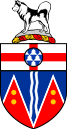
The coat of arms of the Yukon Territory shows in the upper part of the blazon a St. George's Cross which is covered in the middle by a blue-white structured disk. The lower part of the blazon is blue with a vertical white bordered blue wave line in the middle, in that one stand out from underneath two red wedges. The wedges carry per two golden points in the top. The crest is made by a golden torus, on which is positioned a snow hill , on which on the contrary stands an Alaskan Malamute Dog. The coat of arms is below finited by local plants. The red wedges with the golden points represent the gold-bearing mountains and the wave line the numerous rivers of the country. The golden dots stand for the rich gold finds that were made here.
Source:
Wikipedia (D)
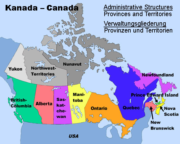
Landkarte/Map:
Volker Preuß
Area: 186.271 square miles
Inhabitants: 42.986 (2016), thereof 21% native Indians
Density of Population: 0,23 inh./sq.mi.
Capital: Whitehorse, 25.085 inh. (2016)
official Languages: English, French
Currency: Canadian currency
Time Zone: GMT – 7 h
Source:
Wikipedia (D)
1670 · English furriers establish the Hudson's Bay Company (HBC), the HBC colonizes in the afteryears whole Canada between New France, the Rocky Mountains, Labrador and the northern rand of the Hudson Bay
1842 · furriers of the HBC range the region
1869 · the Hudson's Bay Company (HBC) cedes all their territorial rights and prerogatives to the British Dominion of Canada, the area of the today's Yukon Territory belongs initially to the Northwest Territories
1880 · initial gold finds in Yukon
1886 · Yukon, in the outer northwest, becomes an own district within the Northwest Territories
1887 · foundation of Dawson City (afterward capital)
1895 · establishment of the Yukon Territory by dividing of the district off the Northwest Territories
1896 · discovery of big gold finds near Bonance Creek on the Klondyke River
1905 · end of the gold rush in the Yukon Territory
1952 · Whitehorse City becomes capital of the Yukon Territory instead of Dawson City
2003 · renamed in "Yukon"
Source:
Atlas zur Geschichte,
World Statesmen,
Wikipedia (D),
Discovery '97
The name of the territory goes back to the river of the same name, which flows centrally through the country. In the language of the Gwich'in Indians (also: Gwitchin, Kutchin) he is called "yu-kun-ah", which can be translated as "big river". In 2003, the "Yukon Territory" was renamed in "Yukon".
Source:
Wikipedia (D)
