mobile View, to the German Version tap the flag


- Republic of Komi
- federal component of the Russian Federation (Russia)
- own name: Komi Respublika
• Flag
• Historical Flags
• Meaning/Origin of the Flag
• Coat of Arms
• Map
• Numbers and Facts
• History
• Origin of the Country's Name

National flag,
ratio = 2:3,
Source, by: Wikipedia (FR)


1937–1938,
Flag of the autonomous soviet republic,
ratio = 1:2,
Source, by: World Statesmen
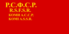
1938–1954,
Flag of the autonomous soviet republic,
ratio = 1:2,
Source, by:
World Statesmen
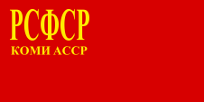
1954–1991,
Flag of the autonomous soviet republic,
Source, by: World Statesmen
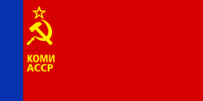
1991–1997,
National flag,
ratio = 1:2,
Source, by:
Wikipedia (FR)
look also:
Flag history of the soviet republics of the USSR
The flag was adopted on 27th of November in 1991, in the format-ratio of 1:2, on 17th of December in 1997 the format was changed to 2:3. The old format-ratio of 1:2 goes back to the flags of the Soviet Union. The Bolshevist flags were almost designed in 1:2 format, as a visible break with the monarchist and bourgeois format-ratio of 2:3. The flag represents the nature of Komi. Blue represents the splendor and vastness of the northern sky. Green stands for the nature, its fullness and the Taiga Woods. White stands for the snow, the purity of the nature of the north, and for simplicity and rigour. According to a different interpretation, white stands for the equality and unity of the people and cultures who living in Komi. The flags, which were used in the Soviet era corresponded all to the same pattern as it was intended for the Soviet Autonomous Republics: Between 1923 and 1937 frequently only a single-coloured red bunting with a golden inscription, showing the name of the country. Sometimes only as a shortcut, sometimes the full name, sometimes only in Russian or even multilingual. From about 1937 hammer, sickle and star were sometimes added. From about the mid-50s multicolored flags were introduced for the republics of the Soviet Union, whose knitting patterns had to be taken over by the subordinated autonomous Soviet republics.
Source:
Volker Preuß, Wikipedia (EN), Flaggen Enzyklopädie
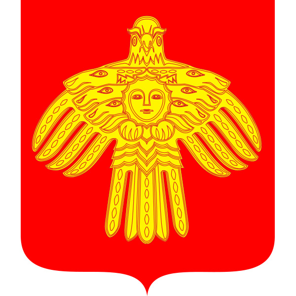
Coat of arms of Komi,
Source: Russiatrek
geographical position within Russia:
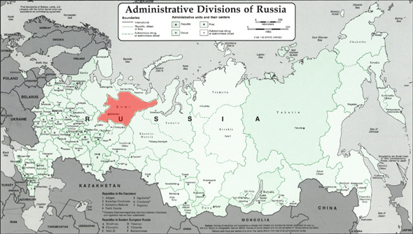
Source: Freeware, russiamap.org, modyfied by: Volker Preuß
enlarge – click or tap here
Map of the country:
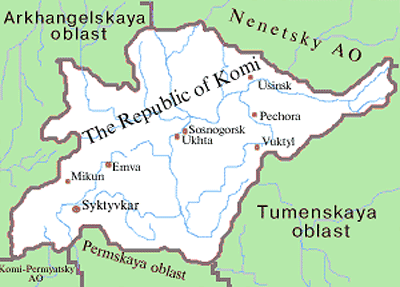
Source: Russiatrek
Area: 160.916 square miles
Inhabitants: 901.189 (2010), thereof 62% Russians, 22% Komi (Zyryans), 4% Ukrainians, 1% Tatars, 1% White-Russian, 0,6% Germans
Density of Population: 6 inh./sq.mi.
Capital: Syktywkar (to 1929 Ust-Sysolsk), 235.000 inh. (2010)
official Languages: Russian, Komi-Zyryan
Currency: Russian currency
Time Zone: GMT + 3 h
Source: Wikipedia (DE)
1472 · subjection by Russia
1921 · erection of the Soviet dictatorship, proclamation of the Autonomous Region of Komi
1936 · elevation to the Autonomous Socialistic Soviet Republic of Komi, in the afteryears Russification
1950 · interdiction of the Komi-Zyryan language in the education system
1991 · proclamation of the Republic of Komi
31st of December in 1991 · the Soviet Union dissolves, the constitution of the Russian Socialist Federative Soviet Republic (RSFSR, Russia), a former substate of the Soviet Union, remains in force for the time being
25th of December in 1993 · a new constitution for Russia (Russian Federation) comes into force, and the relationships with the members of the federation is re-regulated in this way
Source:
Atlas zur Geschichte,
World Statesmen,
Russiatrek,
Die Völker der Erde,
Wikipedia (D)
The name of the country has its roots in the Finno-Ugric people of the Komi who live here. The members of this people were also called Zyryans. Since the 1950s, they have always been a minority in their own country.
Source:
Volker Preuß
Surftip: