mobile View, to the German Version tap the flag


Sint Maarten


Contents

Flag

Meaning/Origin of the Flag

Coat of Arms

Meaning/Origin of the Coat of Arms

Map

Numbers and Facts

History

Origin of the Country's Name


Flag

National flag Flagge Fahne flag Sint Maarten St. Maarten St. Martin
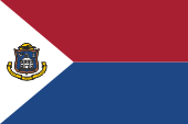
Flag of St. Maarten,
ratio = 3:5,
Source, by: Flags of the World


hoch/up


Meaning/Origin of the Flag

The flag of St. Maarten was adopted on 13th of June in 1985. It shows the colours red and blue in two horizontal stripes, as well as the colour white and the country's coat of arms in an isosceles triangle on the flag pole. These are the colours of the Netherlands and also of the former Netherlands Antilles. The colours of the flag of the Netherlands have been defined since 1958 as follows, hexadecimal: red ("bright vermilion") = #A91F32 which would correspond to Pantone 187, blue ("cobalt blue") = #1E4785 which would correspond to Pantone 541.

Source: Flags of the World, Wikipedia (DE), Volker Preuß

hoch/up


Coat of Arms


Wappenschild Wappen Coat of arms blazon Sint Maarten St. Maarten St. Martin
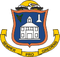
Coat of arms of Sint Maarten,
Source: Wikipedia (DE)

hoch/up


Meaning/Origin of the Coat of Arms

The coat of arms of St. Maarten shows on a blue, orange surrounded shield a court house, a memorial and a sage blossom. Orange is the colour of the Netherlands royal house of Oranien-Nassau. The memorial remembers the partition of the island among France and the Netherlands in the year 1648, sage is the national plant. Above the shield a flying pelican in front of the sunwheel. In the golden banner below the shield the motto of the island: "SEMPER PROGREDIENS" → "constant progress".

Source: Flags of the World, Flaggen Enzyklopädie, Wikipedia (DE), Volker Preuß

hoch/up


Map

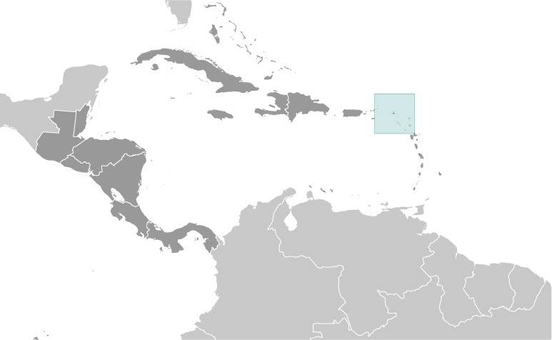
Location:

Source: CIA World Factbook

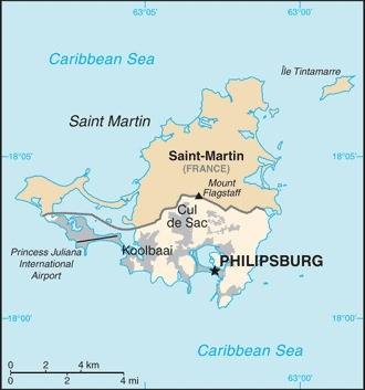
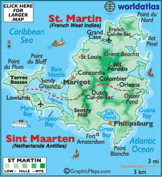
Map of the country:

Source: CIA World Factbook

Map of the country:

Source: Freeware, https://www.worldatlas.com,
enlarge – click here

hoch/up


Numbers and Facts

Area: 13 sq.mi., The Island of St. Martin in the North of the Lesser Antilles was divided in the year 1648 between France (northern part) and the Netherlands (southern part).

Inhabitants: 40.614 (2018), thereof 65% Dutch citizens, 5% Haitian, 5% Dominican, 5% Jamaican

Religions: 50% Protestant, 30% Roman Catholic

Density of Population: 3.094 inh./sq.mi.

Capital: Philipsburg, 1.327 inh. (2011)

official Languages: Dutch, English

other Languages: Spanish, Papiamento

Currency: 1 Antillean Guilder (ANG, NAf) = 100 Cent

Time Zone: GMT – 4 h

Source: Wikipedia (DE)

hoch/up


History

1493 · Christopher Columbus discovers the island on 11th of November, the day of St. Martin, and calls it "Isla de San Martín"

1625 · founding of a French settlement

1631-1633 · St. Martin's colony of the Netherlands

1633 · St. Martin is a colony of Spain

1638 · founding a Spanish settlement

1648 · founding of a French settlement

23rd of March in 1648 · official division of the island between France and the Netherlands

1651-1665 · the French part of St. Martin is a fief of the Order of Malta

1672-1679 · the French part of St. Martin is occupied by England

1679-1689 · the entire island is occupied by France

1689-1792 · the Dutch part of St. Martin is under administration of the Dutch West India Company

1690-1699 · the entire island is occupied by England

1699-1702 · the entire island is occupied by France

1702 · the official French part of St. Martin is occupied by United Kingdom

1703-1713 · the French part of St. Martin is occupied by the Netherlands

1744-1748 · the French part of St. Martin is occupied by United Kingdom

1759-1763 · the French part of St. Martin is occupied by United Kingdom

1779-1781 · the entire island is occupied by France

1781 · the entire island is occupied by United Kingdom

1781-1784 · the French part of St. Martin is occupied by United Kingdom

1793-1794 · the entire island is owned by the Netherlands

1794-1795 · the French part of St. Martin is occupied by United Kingdom

1795-1801 · the entire island is occupied by France

1801-1802 · the entire island is occupied by United Kingdom

1810-1816 · the entire island is occupied by United Kingdom

1816 · official restore the division between France and the Netherlands

1828 · The Dutch part of St. Martin, Aruba, Bonaire, Curaçao, Saba, Sint Eustatius, and Dutch Guiana become combined as Dutch West India and subordinated to the governor of Dutch Guiana as Governor General

1848 · The Dutch part of St. Martin, Aruba, Bonaire, Curacao, Saba, Sint Eustatius are called "colony Curaçao en onderhorigheden" (Colony of Curaçao and Dependencies)

1936 · the Dutch part of St. Martin officially takes over the Dutch spelling "Sint Maarten" as name of the country

1948 · the "colony Curaçao en onderhorigheden" is renamed to "Netherlands Antilles"

1954 · the Netherlands Antilles are an autonomous part of the Netherlands

1994 · referendum in Sint Maarten in favor of remaining in the Netherlands

2000 · referendum in Sint Maarten in favor of a separate status within the Netherlands

2006 · Sint Maarten and Curaçao receive a separate status within the Netherlands

10th of October in 2010 · the Netherlands Antilles are dissolved, Sint Maarten becomes an autonomous country of the Netherlands

Source: World Statesmen, Wikipedia (D), Discovery '97

hoch/up


Origin of the Country's Name

On the name-day of St. Martin, on 11th of November in 1493, Christopher Columbus discovered the island, and calls it on this occasion "Isla de San Martín". The island became divided in 1648 between France and the Netherlands. Generally valid is the name "St. Martin", but the French part of St. Martin's is called "Saint-Martin", the Dutch part is called "Sint Maarten". Holy Martin lived from 316 to 397 A.D. was Bishop of Tours and divided as soldier his coat with a beggar.

Source: Wikipedia (D), Volker Preuß

hoch/up


to start page click here