• Flags
• Historical Flags
• Meaning/Origin of the Flag
• Coat of Arms
• Meaning/Origin of the Coat of Arms
• Aircraft Roundel
• Map
• Numbers and Facts
• History
• Origin of the Country's Name
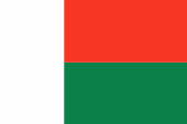
National flag,
ratio = 2:3,
Source, by: Flags of the World


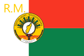
Flag of the President,
ratio = 2:3,
Source: Wikipedia (D)


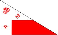
1810–1885,
Merina-Kingdom of Madagascar,
National flag,
Source, by: Flags of the World
1883–1897,
Merina-Kingdom of Madagascar,
Flag of the Queen,
Source, by: Flags of the World, Wikipedia (D)
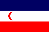
1885–1896,
French protectorate of Madagascar,
National flag,
Source, by: Flags of the World

1896–1958,
Madagascar is a French colony
The today's flag of Madagascar was officially hoisted for the first time in context with the declaration of autonomy on the 21th December in 1958. It was the winner in a designing competition. As the country on the 26th of June in 1960 achieved the independence this flag was maintained. It shows two horizontal stripes in red and green, as well as a vertical white stripe on the hoist. All stripes have the same dimensions. The colours should today have the following meaning: White stands for purity and peace, red stands for sovereignty and readiness for defense and green stands for the hope for a better future. The colours of the flag are indicated as follows: Red = warm red, Green = Pantone 348. The colours red and white are derived from flags, which were in use by the Merina Empire in the 19th century, which at that time ruled over the whole island. The Merina, which live in the central highlands are divided into three castes: Andriana, Hova und Andevo. They are – like 98% of the Madegassian population – of Indonesian/Malaysian descent. Interesting is, that also other countries with Indonesian/Malaysian population, like Indonesia, Malaysia, West Irian, East Timor, the Molucca Islands, but even some Oceanian countries (e.g.: Philippine Islands) use flags with the combination of the colours red and white. As Madagascar became a French protectorate they added to the flag of Madagascar a blue stripe above, and in the white middle stripe a red half-moon. In this way blowed the French colours in horizontal arrangement on the island. As the island in 1896 became ultimately a French colony, it was not allowed to use an own flag – like in all French colonies. Ther was only to use the French tricolor. During the big uprising in the year 1947 emerge again red-white flags. It is that's why not surprising, that on the 21st of October in 1958 – because of the declaration of the autonomy – was adoped again a flag with the combination of red and white. But there was added green. It stands for the coastal residents (Betsimisaraka).
Source:
Flaggen und Coat of arms of the Welt,
Die Welt der Flaggen,
Flaggen Wappen Hymnen,
Flags of the World
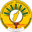
since 1998,
Coat of arms of Madagascar,
Source:
Corel Draw 4
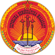
1975–1992,
Coat of arms of Madagascar,
Source:
Corel Draw 4
The today's coat of arms is actually a seal and was introduced in the year 1998. It is a memory to the coat of arms of the years 1958–1975. It is a golden round disk and shows in the middle the map of the island on a smaller silvery disk and behind the fronds of the Ravenala Tree. Below the silvery disk a cow's head and rice fields. On the upper side the name of the state: "Repoblikan'i Madagasikara" and on the lower side the motto of the state between two rice ears: "Tanidrazana, Fahafahana, Fahamarinana" → "Fatherland, Revolution, Justice". The coat of arms between 1975 and 1992 was as well a round seal, but it was red and showed in its middle rifle, spade and writing plume – united to one trident – in front of a rising sun. Above that the then name of the state and the red star of socialism. Below the trident a sprocket as symbol for industrialization. The motto on the banner was: "Tanidrazana, Tolom Piavotana, Fahafahana" → "Fatherland, Freedom, Revolution".
Source:
Flaggen und Coat of arms of the Welt,
Die Welt der Flaggen,
Flaggen Wappen Hymnen,
Volker Preuß
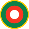
Aircraft Roundel,
Source, by: Wikipedia (EN)
Location:
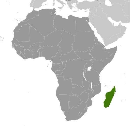
Source: CIA World Factbook
Map of the country:
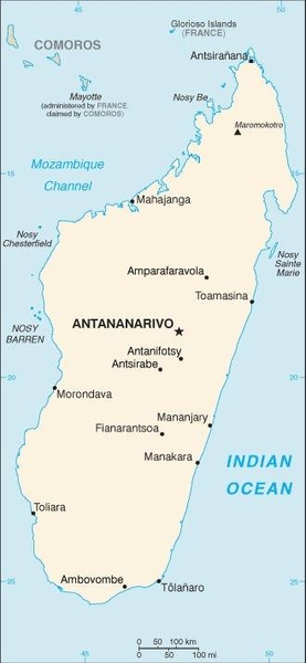
Source: CIA World Factbook
Area: 226.755 square miles
Inhabitants: 27.690.000 (2020), thereof 26 % Merina, 15 % Betsimisaraka (Coastal Residents), 12 % Betsileo, 46 % other
Religions: 52% Animist, 23% Roman Catholic, 18% Protestant, 7% Muslim
Density of Population: 112 inh./sq.mi.
Capital: Antananarivo(Tananarive), 1.274.225 inh. (2018)
official Languagen: Malagasy, French
Currency: 1 Ariary (MGA, Ar) = 5 Iraimbilanja
Time Zone: GMT + 3 h
Source:
Wikipedia (DE)
ca. 2.000 B.C. · Persian, Arabic and Melanesian settlement
ca. 900 B.C. · immigration of the Malaysian Merina tribe
1500 · the Portugese seafarer Diego Diaz discovers the island and debarks on Madagascar
16th cent. · Portugese and French establish bases on the coast
1642 · France officially appropriates Madagaskar Island, but there exists at this point in time only Fort Dauphin (nowadays: Taolanaro) as base on the southern coast of the island
1643 · appropriation of the on the eastern coast positioned Ste. Marie Island by France, French attempts for settlement fail
1787 · the Merina Empire expands over nearly whole Madagascar, specially in the north and the east of the island
1810–1828 · regency of the King Radama I., further territorial increase for the Merina Empire, specially in the west of the island, United Kingdom conquers some French bases in the south of the island → good dealings of Madagascars with United Kingdom
1828–1861 · regency of the Queen Ranavalona I. (Widow of King Radama I.)
1833 · appropriation of the on the western coast positioned Be Island (Nosy Be) by France
1861–1863 · regency of the King Radama II., he gets murdered
1863–1883 · regency of the Queen Razoherina I. (Widow of King Radama II.)
1864–1895 · the prime minister of the Merina Empire, Rainilaiarivony, trys to reform the Merina State after the example of Japan
1883 · appropriation of the on the eastern coast positioned place Tamatave (nowadays: Toamasina) by France
1883–1897 · regency of the Queen Ranavalona III.
1885 · appropriation of the on the northern coast positioned place Diego Suarez (nowadays: Antseranana) by France, further military operations by France, specially on the coast
1885 · France establishes its protectorate over Madagascar
1895 · beginning of the French colonial conquesting war
1896 · Madagascar becomes a French colony
1939–1945 · Second World War: Madagascar is subordinated until 1942 to the French government in Vichy, British and South African troops conquer in 1942 Madagascar and subordinate the island to the government of the Free France of General de Gaulle
1946 · claims for autonomy
1947 · great anti-colonial uprising, crushed by French troops
14th of October 1958 · France grants autonomy, proclamation of the autonomous republic
26th of June 1960 · independence
1973 · the French troops leave the country
1990 · introduction of a veritable multi-party-system
1992 · new constitution
1998 · change of the constitution
2006 · attempted military coup
Source:
Atlas zur Geschichte,
Wikipedia (D),
Discovery '97
The designation "Madagascar" is actually a by Europeans used term. The indigenous people name their island and the on it situated state occasional like their language: "Malagasy", what means "Moon Island". But the term "Madagascar" derives anyhow back to the Malaysian settlers, which named the island probably like their original homeland "Macasar". "Macasar" is a city in the south of Celebes Island (Sulawesi) in the today's Indonesia. But it is named today "Ujung Pandang".
Source: Handbuch der geographischen Namen, Volker Preuß

