mobile View, to the German Version tap the flag


- Republic of Mauritius
- parliamentary republic
- own names:
English: Republic of Mauritius
French: République de Maurice
• Flags
• Historical Flags
• Meaning/Origin of the Flag
• Coat of Arms
• Meaning/Origin of the Coat of Arms
• Aircraft Roundel
• Map
• Numbers and Facts
• History
• Origin of the Country's Name

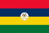
National flag,
ratio = 2:3,
Source, by:
Flags of the World


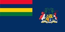
Merchant flag,
ratio = 1:2,
Source, by:
Flags of the World

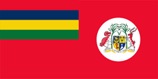
Flag of the government (state flag),
ratio = 1:2,
Source, by:
Flags of the World
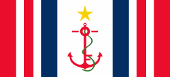
Flag of the Coast Guard,
ratio = 5:11,
Source, by:
Flags of the World
since 1992,
Flag of the President,
ratio = 2:3,
Source, by:
Flags of the World

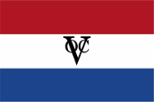
1660–1798,
Flag of the Dutch East India Company,
Source, by: commons.wikimedia.org
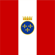
1715–1767,
Flag of the French East India Company,
Source, by: Picaballo, CC BY-SA 3.0, via Wikimedia Commons
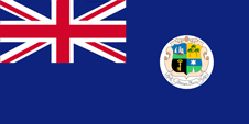
1869–1906,
Flag of the government (state flag),
ratio = 1:2,
Source, by:
Flags of the World
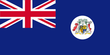
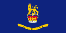
1906–1923,
Flag of the government (state flag),
ratio = 1:2,
Source, by:
Flags of the World
1923–1968,
Flag of the government (state flag),
ratio = 1:2,
Source, by:
Flags of the World
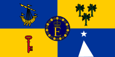
1968(?)–1992,
Flag of the Queen,
ratio = 1:2,
Source, by:
Flags of the World

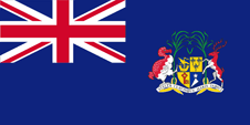
1968–1992,
Flag of the Governor General,
ratio = 1:2,
Quelle, nach:
Flags of the World
The today's flag of Mauritius was hoisted for the first time on 12th of March in 1968 (by other sources on 9th of January in 1968). It shows four horizontal stripes in red, blue, yellow and green. Red stands for the struggle for independence, blue for the ocean around the island, yellow for the sun and the golden light of independence and green for the fruitful soil and its vegetation. The colours were borrowed from the colours of the coat of arms. The flag was designed by the College of Arms (Herald Office in London). The colours of the flag are laid down in the "Mauritius Standard Bureau". They are given as follows: Red = Pantone 185, Blue = Pantone 295, Yellow = Pantone 116, Green = Pantone 356. Mauritius is orientated in the British Ensign-System. This points to the connexions to the United Kingdom. The United Kingdom introduced a flag system in 1864 in which:
• war ships fly the "White Ensign" (naval flag), a white flag often with an uninterrupted red St. George's-Cross and with the Union Jack in the upper staff quadrant of the flag,
• merchant ships fly a "Red Ensign" (also named "Civil Ensign" → civil flag, the real merchant flag), a red flag with the Union Jack in the upper staff quadrant of the flag, and
• governmental ships fly the "Blue Ensign" (flag for the use by the gouvernment → the actual state flag), a blue flag with the Union Jack in the upper staff quadrant of the flag.
Mauritius uses a Red Ensign as merchant flag and a Blue Ensign as state flag (instead of the Union Jack with its own national flag in the upper corner).
Source:
Flaggen Wappen Hymnen,
Die Welt der Flaggen,
Wikipedia (EN),
Volker Preuß
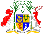
since 1906,
Coat of arms of Mauritius,
Source: Corel Draw 4
The coat of arms was awarded on the 25th of August in 1906 by King Edward VII. In the shield a vessel, it stands for the settlement from outside, tree palm trees, they stand for the tropical vegetation and the three dependencies, a key and a peak with a star, they stand for the strategic position of the country corresponding to the motto in the coat of arms: "Stella Clavisque Maris Indici" → "Star and Key of the Indian Ocean". Shield supporters are a Dodo (Dronte) and a Sambur Deer with sugarcane.
Source:
Flaggen Wappen Hymnen,
Die Welt der Flaggen
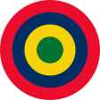
Aircraft Roundel,
Source, by: Wikipedia (EN)
Location:
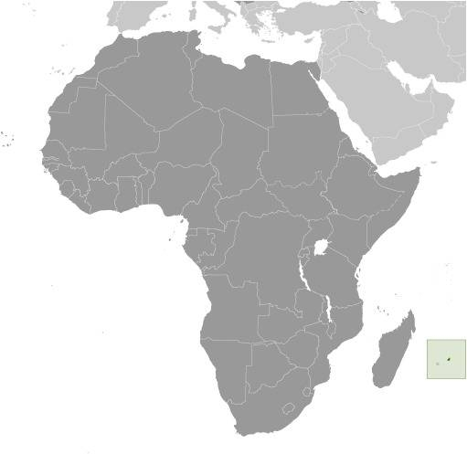
Source: CIA World Factbook
Map of the country:
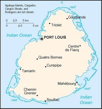
Source: CIA World Factbook
Area: 788 square miles, thereof Mauritius 720 sq.mi. (1.215.530 inh.), and the Dependencies: Rodrigues Island 42 sq.mi. (41.700 inh.), Agalega Islands 9 sq.mi. (300 inh.), Cargados Carajos Isls. 1,1 sq.mi. (35 inh.)
Inhabitants: 1.300.000 inh. (2020), thereof 68% Indians, 27% Creole (Africans), 3% Chinese, 2% Europeans (Frenchmen)
Religions: 48% Hindu, 26% Roman Catholic, 6% Protestant, 17% Muslim, 1% Bahai, 1% Non-Religious
Density of Population: 1.650 inh./sq.mi.
Capital: Port Louis, 145.793 inh. (2020)
official Languages: English, French
important Intercourse-Language: Morisyen (French Creole)
other Languages: Bhojpuri-Hindi, Urdu, Tamil, Chinese
Currency: 1 Mauritius Rupee (MUR, Re) = 100 Cents
Time Zone: GMT + 4 h
Source:
Wikipedia (D)
antiquity · the island is uninhabited, visits by Phoenicians, Arabs and Malays
1510 · discovery by the Portugese seafarer Pedro de Mascarenhas
1598 · the Netherlands occupy and populate
the island and name it Mauritius
1638 · the Dutch establish a settlement
1710 · the Netherlands give the island up
1715 · French East India Company appropriates the island, renamed
in Île de France
1767 · France appropriates the island
1810 · occupation by British troops
1814 · France cedes the Île de France officially to United Kingdom, the island becomes as Mauritius a British crown colony
1885 · first constitution
since 1834 · mass-immigration of employees from India
1958 · United Kingdom relaxes the colonial structures
1959 · first free elections
7th of July 1961 · United Kingdom grants autonomy
1965 · race riots
12th of March 1968 · independence in the framework of the Commonwealth, race riots
12th of March 1992 · change of constitution, Mauritius becomes republic with a President as chief of state but remains in the Commonwealth
1999 · race riots
Source:
Atlas zur Geschichte,
Wikipedia (D),
Handbuch der geographischen Namen
At the first European settlement by the Netherlanders the island was named by them after Moritz (Neth. Maurits) of Orania-Nassau, the then supreme commander of the Netherlands troops.
Source:
Handbuch der geographischen Namen
