|
|
| Übersicht – Contents: | |
|
|
| Übersicht – Contents: | |
Flagge – Flag: |
|
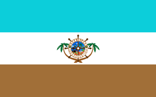 |
seit/since 2009, Flagge der Corn-Inseln – flag of the Corn Islands, Quelle/Source: Municipal Government of Corn Island, CC BY-SA 4.0, via Wikimedia Commons |
| Die Corn-Inseln haben seit 2009 eine eigene Flagge. Vorher wurde seit 1971 die Flagge Nikaraguas verwendet. Von 1914 bis 1971 waren die Inseln ein US-am. Marine- und Luftwaffenstützpunkt. |
The Corn Islands have an own flag since 2009. Before the was in use the flag
of Nicaragua since 1971. From 1914 to 1971 the islands were an US-american navy and air force base. |
| Quelle/Source: Wikipedia (D) | |
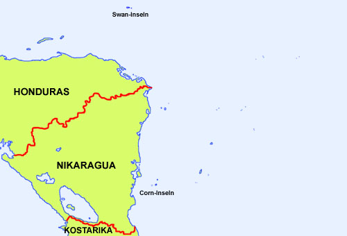
| Lage der Corn-Inseln – Position of the Corn Islands: |
|
| Landkarte/Map: Volker Preuß |
| Zahlen und Fakten – Numbers and Facts: | |
|
|
|
|
|
|
|
|
|
|
|
|
|
|
|
|
| Die
Corn-Inseln wurden wahrscheinlich im Jahre 1502 von Kolumbus entdeckt. Die
Spanier nahmen die Inseln zwar als Islas de los Manglares in Besitz,
kolonisierten sie jedoch nicht, so dass sie sich zu einem Piratennest der
Bukanier entwickelten, und gerieten nach 1697 allmählich unter britischen
Einfluss. Seit dem Beginn des 19. Jahrhunderts gab es Projekte für den Bau eines Kanals durch die Landenge von Mittelamerika. Hauptinteressenten waren Großbritannien – die damalige Hauptmacht in der Karibik – und die aufstrebende USA. Ziel beider Mächte war die Inbesitznahme eines Landstreifens zwischen Atlantik und Pazifik und der Bau eines Kanals unter eigener Souveränität. Großbritannien besaß die Karibischen Inseln und hatte mit Britisch-Honduras und der Mosquitoküste erste Gebiete auf dem Festland gesichert. Im Clayton-Bulwer-Vertrag von 1850 einigten sich beide Länder auf die Neutralität eines künftigen Kanals und auf den Verzicht weiterer territoriale Erwerbungen. Die USA nahmen 1856 die Seranilla-Bank, die Seraña Bank, die Quita Sueño Bank, die Roncador Cays, die Petrel-Inseln (Bajo Nuevo Bank) und die Insel Navassa in Besitz, angeblich wegen deren Guanovorkommen. Die USA wurden auch auf dem amerikanischen Festland aktiv. Großbritannien räumte 1860 die Mosquitoküste und übergab sie an Honduras und Nikaragua. Die Corn-Inseln wurden im Jahre 1894 offiziell von Nikaragua in Besitz genommen. Für den Bau des Kanals bot sich Landenge von Panama an, wo Ferdinand Vicomte de Lesseps im Jahre 1879 mit den Bauarbeiten begonnen hatte. Es gab jedoch auch ein Projekt namens "Trans-Nicaragua-Canal", das von den USA forciert wurde. Als Lesseps wegen finanzieller Schwierigkeiten 1889 seine Arbeiten am Panamakanal einstellen musste, und die Bemühungen um einen Weiterbau 1899 scheiterten, erwarben die USA im Jahre 1901 das alleinige Recht zur Fertigstellung des Kanals und besetzten obendrein 1905, 1907 und 1911 Honduras, und 1912 Nikaragua. Kolumbien wollte die Panama-Kanalzone jedoch nicht an die USA abtreten, so dass die USA die Gründung der Republik Panama forcierten, welche die Kanalzone an die USA abtraten. Ein klarer Bruch des Clayton-Bulwer-Vertrags mit Großbritannien von 1860. Am 15.08.1914 wurde der Panamakanal eröffnet. Die USA hielten jedoch die Option "Trans-Nicaragua-Canal" wegen der politischen Schwierigkeiten mit Kolumbien und Panama offen. So wurden zur Sicherung des militärischen Einflusses die Corn-Inseln 1914 von USA für 99 Jahre von Nikaragua gepachtet und 1924 die Swan-Inseln (Honduras) besetzt, und beide als Marine- und Luftwaffenstützpunkt ausgebaut. Da der Panamakanal fest in der Hand er USA war, waren die Corn-Inseln und auch die Swan-Inseln als Stützpunkte überflüssig geworden, so dass die USA den Pachtvertrag über die Corn-Inseln vorfristig kündigten und im Jahre 1971 die Corn-Inseln und auch die Swan-Inseln räumten. |
| The Corn
Islands were probably discovered in the year 1502 by Columbus. The Spanish
appropriated the islands indeed as Islas de los Manglares, but they did not
colonize them so that they developed as a pirate nest of the Buccaneers and
came after 1697 gradually under British influence. Since the beginning of the 19th century there were projects to build a canal through the Isthmus of Central America. The most interested states have been United Kingdom – the then great power in the Caribbean Sea – and the aspiring USA. Target of both powers was the appropriation of a land stripe between Atlantic and Pacific Ocean and the construction of a canal under own sovereignty. United Kingdom possessed the Caribbean Islands and had secured with British-Honduras and the Mosquito Coast first territories on the mainland. In the Clayton-Bulwer Treaty from 1850 both countries agreed about the neutrality of a coming canal and to renounce further territorial appropriations. The USA appropriated in 1856 the Seranilla Bank, the Seraña Bank, the Quita Sueño Bank, the Roncador Cays, the Petrel Islands (Bajo Nuevo Bank) and Navassa Island, ostensibly because of its guano resources. The USA became active even on the American mainland. United Kingdom leaved the Mosquito Coast and gave it to Honduras and Nicaragua. The Corn Islands were officially appropriated by Nicaragua in the year 1894. The Isthmus of Panama was ideally for the Canal where Ferdinand Vicomte de Lesseps startet in the year 1879 with the construction works. There was however a project named "Trans-Nicaragua-Canal" which was accelerated by the USA. As Lesseps because of financial problems has to stop ist works on the Panama Canal in 1889 and the endeavours for a continue failed in 1899, acquired the USA in the year 1901 the exclusive right to complete the canal and occupyd over and above in 1905, 1907 and 1911 Honduras, and in 1912 Nicaragua. But Colombia would not cede the Panama Canal Zone to the USA, so that the USA strengthend the establishment of the Republic of Panama which ceded the canal zone to the USA. A evident break of the Clayton-Bulwer Treaty with United Kingdom from 1860. The Panama Canal was inaugurated on 15th of August in 1914. The USA kept open the option for the "Trans-Nicaragua-Canal" because of the political difficulties with Colombia und Panama. In this way the Corn Islands were leased in 1914 for 99 years from Nicaragua and the Swan-Islands (Honduras) were occupied in 1924 by the USA to protect the military influence and both were developed as navy and air force bases. As the Panama Canal was steady in the hand of the USA became the Corn Islands and also the Sawn Islands needless as bases, so that the USA terminated the leasing treaty earlier and left in 1971 the Corn Islands and the Swan Islands. |
| Quelle/Source: Volker Preuß |
| Die Corn-Inseln hießen bis ins 19. Jahrhundert hinein "Islas de los Manglares" also "Mangroven-Inseln". Wahrscheinlich setzte sich mit der Besiedlung und Ausbeutung der Inseln der Name "Mais-Inseln" (engl. Corn Islands, span: Islas del Maíz) durch, als Anspielung auf die neben dem Anbau von Kokospalmen, dem Fischfang und dem Fang von Hummern und Langusten einst wichtigste Erwerbsquelle auf den Inseln. Heute sind die Inseln ein wichtiges Tourismusgebiet. | The Corn Islands were named until the 19th century "Islas de los Manglares" ergo "Mangrove Islands". Probably arised in context with the settlement and exploitation of the islands the name "Corn Islands" (span: Islas del Maíz) as hint for the in addition to the cultivation of Cocos palm trees, the fishery and the trapping of lobsters and crayfishs once most important source of earning on the islands. Today the islands are an important area of tourism. |
| Quelle/Source: Wikipedia (D), Volker Preuß | |
