Kastilien-La Mancha |
|
|
|
| Übersicht – Contents: | |
Kastilien-La Mancha |
|
|
|
| Übersicht – Contents: | |
Flagge – Flag: |
|
 |
seit/since 1980, |
 |
seit/since 1980, |
| historische und andere Flaggen – historical and other Flags: | |
 |
1085–1833, |
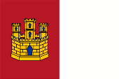
| Die Flagge von Kastilien-La Mancha wurde am 25.01.1980 offiziell eingeführt und am 17.08.1982 per Gesetz bestätigt, als die Autonome Gemeinschaft Kastilien-La Mancha gegründet wurde. Jedoch war die Flagge schon seit 1978 inoffiziell in Verwendung. Sie zeigt das Bild des Wappens (laut Gesetz zeigt das Wappen das Bild der Flagge!), ist vertikal geteilt und zeigt zwei Felder in Karmesinrot und Weiß, sowie in der Mitte des roten Feldes eine goldene Burg mit drei Türmen. Das rote Feld der Flagge mit der Burg entspricht der traditionellen Heraldik von Kastilien, jedoch nicht von Neukastilien, dem ehemaligen Kastilischen Königreich Toledo, auf dessen Gebiet Kastilien-La Mancha heute liegt. Das Kastilische Königreich Toledo hatte als Wappen einen hellblauen Schild mit einer Krone darin. Das weiße Feld der Flagge soll an die Mäntel der Ritter und Kreuzfahrer erinnern, die die Region des heutigen Kastilien-La-Mancha im 12. und 13. Jahrhundert vom Joch der Araber befreiten. Unter der der Regierung des Generals Franco (1936–1975) waren alle regionalen Flaggen verboten. Nach Francos Tod (1975) wurden die regionalen Flaggen wieder eingeführt, bzw. neue geschaffen. Kastilien-La Mancha war bis dato nicht existent, hatte also vorher keine eigene Flagge, so dass im Jahre 1978 die neue Flagge eingeführt wurde, wenn auch zunächst inoffiziell, da Kastilien-La Mancha bis 1982 noch keinen Autonomiestatus hatte. Ämter und Behörden halten sich an die Vorgaben des Artikels 39.1981 des spanischen Gesetzes 6/2, das vorschreibt, dass an mehreren Masten, von denen einer die spanische Flagge zeigt, keine Flagge größer sein darf als die spanische Flagge selbst. Insofern hissen Ämter und Behörden die Flagge im Format 2:3. Privatpersonen halten sich an das Organgesetz Nr. 9/1982 vom 10.10.1982 über das Autonomiestatut von Kastilien-La Mancha, das ein Seitenverhältnis von 1:2 vorschreibt. Die Flagge wird in der Praxis in vielen Formaten reproduziert, und auch das Karmesinrot zeigt viele Varianten die bis zu Purpur gehen können, denn der Farbton des Rot ist nicht festgelegt. |
The flag of Castile-La
Mancha was officially adopted on 25th of January in 1980 and confirmed by
law on 17th of August in 1982, when the Autonomous Community of Castile-La
Mancha was created. However, the flag had already been in unofficial use
since 1978. It shows the image of the coat of arms (according to the law, the coat of arms shows the image of the flag!), is divided vertically and shows two fields in crimson and white, as well as a golden castle with three towers in the centre of the red field. The red field of the flag, with the castle, corresponds to the traditional heraldry of Castile, but not of New Castile, the former Castilian Kingdom of Toledo, on whose territory Castile-La Mancha now lies. The Castilian Kingdom of Toledo had as its coat of arms a light blue shield with a crown in it. The white field of the flag is meant to recall the cloaks of the knights and crusaders who liberated the region of present-day Castile-La Mancha from the yoke of the Arabs in the 12th and 13th centuries. Under the government of General Franco (1936–1975), all regional flags were banned. After Franco's death (1975), the regional flags were reintroduced or new ones were created. Castile-La Mancha did not exist until then, so it did not have its own flag before, so the new flag was introduced in 1978, albeit unofficially at first, as Castile-La Mancha did not have autonomous status until 1982. Offices and authorities comply with the requirements of Article 39.1981 of Spanish Law 6/2, which stipulates that on several poles, one of which displays the Spanish flag, no flag may be larger than the Spanish flag itself. In this respect, offices and authorities fly the flag in a 2:3 aspect ratio. Private individuals adhere to the Organic Law Nr. 9/1982 of 10th of October in 1982 on the Statute of Autonomy of Castile-La Mancha, which prescribes an aspect ratio of 1:2. In practice, the flag is reproduced in many formats, and even the crimson shows many variations that can go as far as purple, because the shade of red is not fixed. |
| Quelle/Source: Wikipedia (ES), Flags of the World, World Statesmen, Volker Preuß | |
Wappen – Coat of Arms: |
|
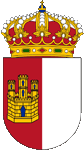 |
seit/since 1983, Wappen von Kastilien-La Mancha – coat of arms of Castile-La Mancha, Quelle/Source, nach/by: HansenBCN, CC BY-SA 3.0, via Wikimedia Commons |
historische Wappen – historical Coats of Arms: |
|
 |
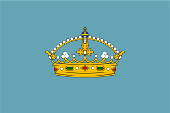
1085–1833, Wappen des Königreichs Toledo – coat of arms of the Kingdom of Toledo, Quelle/Source, nach/by: Wikipedia (ES) |
| Das Wappen von Kastilien-La Mancha wurde am 30.06.1983 und zwar nachdem die Autonome Gemeinschaft Kastilien-La Mancha im Jahre 1982 gegründet worden war. Kurioserweise stand dafür die Flagge Modell. Der Wappenschild ist gespalten und zeigt in seiner heraldisch rechten Hälfte die Heraldik Kastiliens: eine goldene Burg mit drei Türmen auf (karmesin)rotem Hintergrund. Die heraldisch linke Hälfte ist einfarbig weiß und soll an die Mäntel der Ritter und Kreuzfahrer erinnern, die die Region des heutigen Kastilien-La-Mancha im 12. und 13. Jahrhundert vom Joch der Araber befreiten. Oberhalb des Wappenschildes erscheint eine Königskrone. Das rote Feld mit der Burg entspricht der traditionellen Heraldik von Kastilien, jedoch nicht von Neukastilien, dem ehemaligen Kastilischen Königreich Toledo, auf dessen Gebiet Kastilien-La Mancha heute liegt. Das Kastilische Königreich Toledo hatte als Wappen einen hellblauen Schild mit einer Krone darin. |
The coat of arms of
Castile-La Mancha was created on 30th of June in 1983, after the Autonomous
Community of Castile-La Mancha was founded in 1982. Curiously, the flag was
the model for it. The shield is split (divided per pas) and shows in its heraldic right half the heraldry of Castile: a golden castle with three towers on a (crimson-)red background. The heraldic left half is plain white and is intended to recall the coats of arms of the knights and crusaders who liberated the region of present-day Castile-La Mancha from the yoke of the Arabs in the 12th and 13th centuries. A royal crown appears above the escutcheon. The red field with the castle corresponds to the traditional heraldry of Castile, but not of New Castile, the former Castilian Kingdom of Toledo, on whose territory Castile-La Mancha now lies. The Castilian Kingdom of Toledo had as its coat of arms a light blue shield with a crown in it. |
| Quelle/Source: Wikipedia (ES), Volker Preuß | |
|
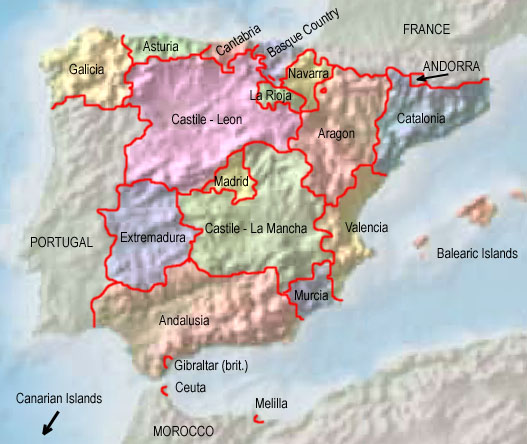
Die autonomen Regionen Spaniens – The autonomous Regions of Spain: Interaktive Landkarte - interactive map |
 |
| Quelle/Source: Freeware, University of Texas Libraries, modyfied by: Volker Preuß |
| Zahlen und Fakten – Numbers and Facts: | |
|
|
|
|
|
|
|
|
|
|
|
|
|
|
| Die Gebiete Kastiliens nördlich des Zentralspanischen Iberischen Scheidegebirges (es erstreckt sich von Südwest nach Nordost) werden Altkastilien genannt und wurden bis etwa 1050 von den Arabern befreit. Die Gebiete südlich davon heißen Neukastilien und wurden bis etwa 1220 von den Arabern befreit. In Neukastilien wurde bereits 1085 das Kastilische Königreich Toledo errichtet, das bis 1833 bestand. Danach wurden ganz Kastilien und das Kastilische Königreich Toledo in Provinzen unterteilt, Neukastilien in die Provinzen Madrid, Guadalajara, Cuenca, Albacete, Ciudad Real und Toledo, aus denen am 16.08.1982 die Autonome Gemeinschaft Kastilien-La Mancha hervorging. Madrid wurde am 01.03.1983 eine eigene Autonome Gemeinschaft. |
| The areas of Castile north of the mountains of the Central System (it extends from southwest to northeast) are called Old Castile and were liberated from the Arabs until about 1050. Today's Castile-La Mancha is the original New Castile, a vast territory in central Spain, south of the mountains of the Central System. These territories were liberated from the Arabs until around 1220, but the Castilian Kingdom of Toledo was established in New Castile already in 1085 and lasted until 1833. Afterwards, the whole of Castile and the Castilian Kingdom of Toledo were divided into provinces, New Castile into the provinces of Madrid, Guadalajara, Cuenca, Albacete, Ciudad Real and Toledo, from which the Autonomous Community of Castile-La Mancha emerged on 16th of August in 1982. Madrid became its own autonomous community on 1st of March in 1983. |
| Quelle/Source: Wikipedia (DE), Volker Preuß |
| Der Name "Kastilien-La Mancha" kombiniert die Begriffe "Kastilien" und "La Mancha". Der geographische Begriff "Kastilien" meint heute ein riesiges Territorium in Zentralspanien. Diese riesige Fläche wurde erst im Zusammenhang mit der Befreiung der Iberischen Halbinsel von den Moslems, der sogenannten Reconquista, und der damit bedingten Ausdehnung des Territoriums des ursprünglichen Kastilien definiert. Die Gebiete nördlich des Zentralspanischen Iberischen Scheidegebirges (es erstreckt sich von Südwest nach Nordost) werden Altkastilien genannt und wurden bis etwa 1050 von den Arabern befreit. Die Gebiete südlich davon heißen Neukastilien und wurden bis etwa 1220 von den Arabern befreit. Der geographische Begriff "La Mancha" bezieht sich auf eine Hochebene im südlichen Neukastilien, ein Steppenland mit rauhem Klima, sehr langen, heißen Sommern und Wassermangel. Der Begriff "La Mancha" hat arabische Wurzeln, die Araber hatten 500 Jahre lang Einfluss in dieser Region, "Al Manschara" heißt "Das dürre Land". | The name
"Castile-La Mancha" combines the terms "Castile" and "La Mancha". Today, the
geographical term "Castile" means a huge territory in central Spain. This huge area was defined only in connection with the liberation of the Iberian Peninsula from the Muslims, the so-called Reconquista, and the consequent expansion of the territory of the original Castile. The territories north of the mountains of the Central System (it extends from southwest to northeast) are called Old Castile and were liberated from the Arabs until about 1050. The areas south of it are called New Castile and were liberated from the Arabs until about 1220. The geographical term "La Mancha" refers to a plateau in southern New Castile, a steppe land with a harsh climate, very long, hot summers, and lack of water. The term "La Mancha" has Arabic roots, the Arabs had influence in this region for 500 years, "Al Manschara" means "The dry land". |
| Quelle/Source: Volker Preuß, Handbuch der geographischen Namen | |


