Taimyr |
|
|
|
| Übersicht – Contents: | |
Taimyr |
|
|
|
| Übersicht – Contents: | |
Flagge – Flag: |
|
 |
bis/to 2007, |
 |
Flagge – flag, |
Bedeutung/Ursprung der Flagge – Meaning/Origin of the Flag: |
|
| Die hellblaue Flagge Taimyrs wurde am 23.05.2000 angenommen und zeigte eine fliegende Sibirische Gans. | The pale blue flag of Taimyr was adoped on 23th of May in 2000 and showed a flying Siberian Goose. |
| Quelle/Source: Flags of the World, Wikipedia (EN) | |
Wappen – Coat of Arms: |
|
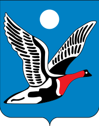 |
Wappen – coat of arms, Quelle/Source: Fred the Oysteri with Adobe Illustrator. [Public domain], via Wikimedia Commons |
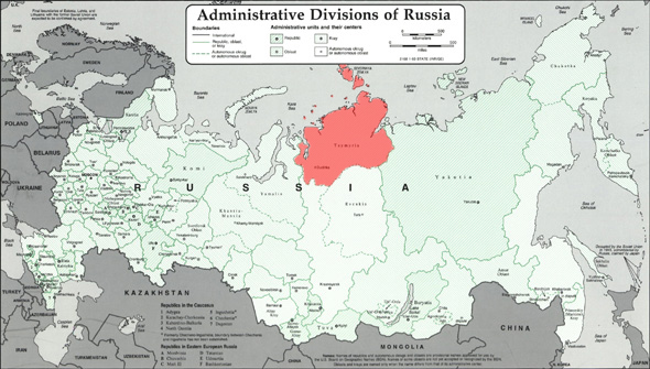
Landkarten – Maps: |
geographische Lage in Russland – geographical position within Russia: |
Zahlen und Fakten – Numbers and Facts: |
|
|
|
|
|
|
|
|
|
|
|
|
|
|
|
|
|
Geschichte: |
|
17. Jhd. · russische Kolonisierung 1922 · Errichtung der Sowjetmacht 07.10.1977 · Errichtung des Nationalen Kreises Taimyr 31.12.1991 · die Sowjetunion löst sich auf, die Verfassung der Russischen Sozialistischen Föderativen Sowjetrepublik (RSFSR, Russland), ein ehemaliger Teilstaat der Sowjetunion bleibt vorerst in Kraft 25.12.1993 · eine neue Verfassung für Russland (Russische Föderation) tritt in Kraft, das Verhältnis zu den Gliedern der Föderation wird damit neu geregelt 2005 · Volksabstimmung über die Auflösung des Landes und den Anschluss an die russische Region Krasnojarsk 01.01.2007 · Auflösung des Landes und Anschluss an die russische Region Krasnojarsk |
History: |
|
17th cent. · Russian colonization 1922 · establishment of the Soviet power 7th of October 1977 · establishment of the National District Taimyr 31st of December in 1991 · the Soviet Union dissolves, the constitution of the Russian Socialist Federative Soviet Republic (RSFSR, Russia), a former substate of the Soviet Union, remains in force for the time being 25th of December in 1993 · a new constitution for Russia (Russian Federation) comes into force, and the relationships with the members of the federation is re-regulated in this way 2005 · plebiscite for the dissolution of the country and the annexion to the Russian Region of Krasnoyarsk 1st of January in 2007· dissolution of the country and the annexion to the Russian Region of Krasnoyarsk |
| Quelle/Source: Atlas zur Geschichte, World Statesmen, Wikipedia (D) |
Surftipp:

