Oklahoma |
|
|
|
| Übersicht – Contents: | |
Oklahoma |
|
|
|
| Übersicht – Contents: | |
Flagge – Flag: |
||
|
||
| historische Flaggen – historical Flags: | ||
|
||
|
||
|
||
|
||
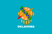
| Die Flagge von Oklahoma war Sieger in einem Wettbewerb und wurde am 02.04.1925 eingeführt und am 09.05.1941 um den Namen des Landes ergänzt. Sie zeigt ein einfarbig hellblaues Grundtuch und in der Mitte einen runden Indianerschild. Davor liegen gekreuzt eine indianische Friedenspfeife und ein Olivenzweig. Das Hellblau steht für Loyalität und Treue, der Schild für Schutz, die Friedenspfeife und der Olivenzweig für Frieden. | The flag
of Oklahoma was the winner in a competition and was introduced on 02.04.1925
and completed on 09.05.1941 by the name of the country. It shows a light blue colored Grundtuch and in the middle of a round Indian shield. Before that are crossed by an Indian peace pipe and an olive branch. The blue stands for loyalty and fidelity, the shield for protection, the peace pipe and olive branch for peace. |
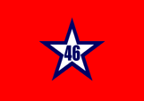
| Am 02.03.1911 war bereits eine Staatsflagge eingeführt worden. Sie war einfarbig rot und zeigte in der Mitte einen blauumrandeten, fünfzackigen weißen Stern mit der Zahl "46" darin. Die Nummer erinnert daran, dass Oklahoma am 16.11.1907 als 46ster Bundesstaat in die USA aufgenommen wurde. | On 2nd of March in 1911 was already introduced a state flag. It was single-colored red and showed in the middle a white, blue-bordered, five-pointed star with the number "46" inside. The number recalles that Oklahoma was admitted to the USA as 46th state on 16th of November in 1907. |
| Oklahoma
wurde 1834 als Indianerterritorium, unter anderem für die "fünf
zivilisierten Nationen" der Creek, Seminolen, Chirokee, Choctaw und
Chickasaw gegründet worden, war also kein Staat und hatte keine eigene
Regierung. Die "fünf zivilisierten Stämme" wurden Verbündete der CSA. Sie kämpften unter einer Variante der zwischen 1861 und 1863 verwendeten Nationalflagge der CSA, dessen Oberecke um fünf rote Sterne und deren wehender Teil die Worte "Cherokee Braves" ergänzt wurden war. Die fünf Sterne roten standen für die fünf zivilisierten Stämme, der große Stern in der Mitte für die CSA-Cherokee. |
Oklahoma was founded in 1834 as Indian Territory, including the "five civilized nations" of the Creek, Seminoles, Chirokee, Choctaw and Chickasaw, and was in this way not a state and did not have its own government. The "Five Civilized Nations" became allies of the CSA. They fought under a variant of the between 1861 and 1863 used national flag of the CSA. Its upper corner was completed by five red stars and its flying end was completed by the words "Cherokee Braves". The five red stars stood for the Five Civilized Nations, the big star in the middle for the CSA-Cherokee. |
| Zahlen und Fakten – Numbers and Facts: | |
|
|
|
|
|
|
|
|
|
|
|
|
|
|
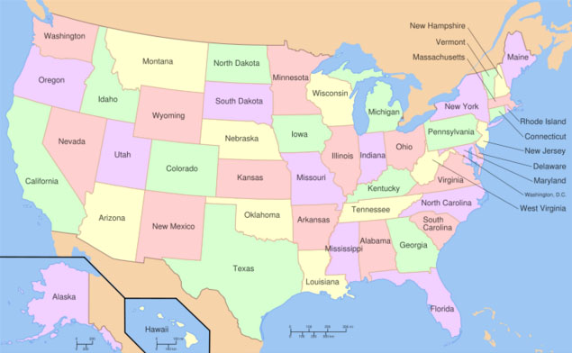
| Landkarte der Bundesstaaten der USA – Map of the
federal states of the USA: interaktiv – interactive |
|
|
ca. 7000 v.Chr.
· Besiedlung durch Indianer (Cheyenne, Arapaho, Kiowa, Komantschen, Wichita,
Osage, Kaw, Pani, Ponce) 1542 · der spanische Entdecker Coronado erreicht die Gegend 1720 · eine französische Expedidion der Gebrüder Mallet erreicht die Gegend, jedoch keine französische Kolonisierung, im Prinzip gehört das Land aber zur französischen Kolonie Louisiana 1762 · Frankreich tritt Louisiana an Spanien ab 1800 · Spanien tritt Louisiana an Frankreich ab 1803 · Frankreich verkauft Louisiana an die USA 26.03.1804 · das Gebiet wird Teil des Louisiana-Territoriums 07.12.1812 · das Gebiet wird Teil des Missouri-Territoriums 02.03.1819 · alles Land südlich 36.5° N wird Teil des Arkansas-Territoriums 1817–1830 · 50.000 aus dem Osten der USA vertriebene Indianer der Stämme der Muskogee, Seminolen, Cherokee, Choctaw und Chickasaw ("fünf zivilisierte Nationen") werden im Gebiet des heutigen Oklahoma angesiedelt, speziell im Jahr 1830 mit dem "Indian Removal Act" 30.06.1834 · Gründung des Indianerterritoriums, alle neun Stämme im Lande erhalten souveräne Rechte und genau abgegrenzte Gebiete (als eigene Staaten mit einer eigenen Verfassung, welche jener der US-amerikanischen Bundesstaaten ähnelt), die USA stationieren nur in Fort Gibson Truppen, Europäern (Weißen) wird das Betreten des Territoriums gesetzlich untersagt 25.11.1850 · Texas tritt den "Public Land Strip" (auch bekannt als: Oklahoma Panhandle, Beaver County, No Man's Land oder Territory of Cimarron) an die Regierung der USA ab 1860 · Texas beansprucht das Greer County (im Südwesten des Landes) für sich 16.03.1861 · die Konföderierten Staaten von Amerika (CSA), richten das Büro für Indianerangelegenheiten ein, um mit den fünf zivilisierten Nationen zu verhandeln: Cherokee, Chickasaw, Choctaw, Muskogee und Seminolen Oktober 1861 bis Juni 1865 · die fünf zivilisierten Nationen sind mit den CSA verbündet, im Indianer-Territorium operieren fast regelmäßig – an der Seite ihrer alliierten indianischen Nationen – konföderierte Truppen aus Texas, Missouri, Arkansas und Louisiana 23. Mai 1865 · der letzte konföderierte General, Brigade-General Degataga Oo-Watee (auf Deutsch: "Der fest auf seinen Beinen im Leben-steht", auf englisch "Stand Watie"), ein Cherokee-Indianer, unterschreibt als Kommandeur einer Brigade indianischer, konföderierter Soldaten einen Waffen-Stillstand, und keine Kapitulationsurkunde 14. Juli 1865 · das indianische, konföderierte Caddo-Bataillon kapituliert, und ist damit die tatsächlich letzte konföderierte Einheit zu Lande, die formell kapitulierte 1866 · "Rekonstruktion", erzwungene Rückkehr der fünf zivilisierten Nationen in die USA 1879 · Beginn der illegalen Besiedlung durch Weiße ("Boomers" oder "Sooners") 1880 · die Regierung der USA verbietet nochmals die Besiedelung des Landes, die illegale Besiedlung geht weiter 1889 · Muskogee und Seminolen verzichten auf Land zugunsten der Siedler 02.05.1890 · Gründung des Oklahoma-Territoriums durch Vereinigung von Indianerterritorium und "Public Land Strip" (Oklahoma Panhandle – die drei heutigen Counties: Cimarron County, Texas County, and Beaver County) 1896 · Texas verzichtet auf seine Ansprüche auf Greer County 04.03.1906 · die souveränen Rechte der Indianer werden abgeschafft 16.11.1907 · Oklahoma wird 46. Bundesstaat der USA |
|
about 7000 B.C.
· Settlement by Indians (Cheyenne, Arapaho, Kiowa, Comanche, Wichita, Osage,
Kaw, Pani, Ponce) 1542 · the Spanish explorer Coronado reaches the area 1720 · a French expedidion of the Mallet brothers reaches the area, but no French colonization, however, the land belongs to the French colony of Louisiana 1762 · France cedes Louisiana to Spain 1800 · Spain cedes Louisiana back to France 1803 · France sells Louisiana to the United States 26th of March 1804 · the area is part of the Louisiana Territory 7th of December 1812 · the area is part of the Missouri Territory 2nd of March 1819 · all the land south of 36.5° N is part of the Arkansas Territory 1817–1830 · 50.000 from the eastern United States displaced Indian tribes of the Creek, Seminole, Cherokee, Choctaw and Chickasaw ("Five Civilized Nations") become settled in today's Oklahoma, specifically in 1830 by the "Indian Removal Act" 30th of June 1834 · founding of the Indian Territory, all nine tribes in the country will receive sovereign rights and well-defined areas (as distinct nations with their own constitution, which is similar to that of federal states of the USA), the USA station troops only at Fort Gibson, Europeans (whites) is prohibited by law to enter the territory 25th of November 1850 · Texas cedes the "Public Land Strip" (also known as: Oklahoma Panhandle, Beaver County, No Man's Land or Territory of Cimarron) to the Government of the United States 1860 · Texas claimes Greer County (in the southwest of the country) 16th of March 1861 · the Confederate States of America (CSA), set up the Bureau for Indian Affairs, to negotiate with the Five Civilized Nations: Cherokee, Chickasaw, Choctaw, Creek and Seminoles October 1861 to June 1865 · the Five Civilized Nations are allied with the CSA, in the Indian territory operate – almost on the side of their allied Indian nations – Confederate troops from Texas, Missouri, Arkansas and Louisiana 23rd of May in 1865 · the last Confederate General, Brigadier General Degataga Oo-Watee (English "Stand Watie"), a Cherokee Indian – commander of a brigade of Indian, Confederate soldiers – signes up an armistice, and not an act of surrender 14th of July in 1865 · the Indian Confederate Caddo Battalion surrenders and is in this way actually the last Confederate unit on land that formally capitulated 1866 · "reconstruction", forced return of the Five Civilized Nations in the USA 1879 · start of the illegal settlement by whites ("Boomers" or "Sooners") 1880 · the government of the USA prohibits again the settlement country, the illegal occupation continues 1889 · Creeks and Seminoles cede land for the settlers 2nd of May 1890 · foundation of the Oklahoma Territory by merger of Indian Territory and "Public Land Strip" (Oklahoma Panhandle – the three today's counties: Cimarron County, Texas County, and Beaver County) 1896 · Texas renounces his claim to Greer County 4th of March 1906 · the sovereign rights of the Indians become abolished 16th of November 1907 · Oklahoma becomes the 46th state of the USA |
| Quelle/Source: Wikipedia (DE), World Statesmen, Jürgen Kaltschmitt, Atlas zur Geschichte, Discovery '97 |
| Das Wort "Oklahoma" stammt aus der Sprache der Choctaw-Indianer. Es war etwa 1830 von einem Choctaw-Häuptling für das zur Besiedlung durch vertriebene Indianer zugewiesene Land am Red River vorgeschlagen worden; "okla" heißt Mann, "humma" heißt rot. Daraus ergibt sich der Name des Landes: "Roter Mann", oder auch "Land des Roten Mannes". | The word
"Oklahoma" comes from the language of the Choctaw Indians. It had been
proposed around 1830 by a Choctaw chief for the settlement by displaced
Indians allotted land near the Red River; "okla" means man, "humma" is red.
Hence the name of the country: "Red Man", or "Land of the Red Man." |