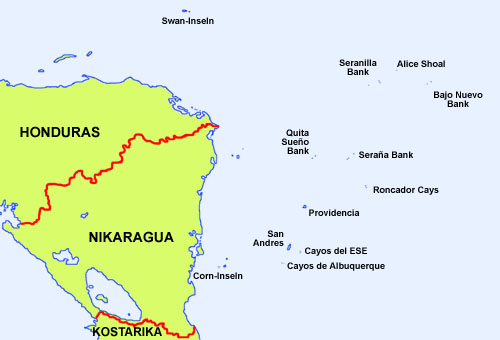
This archipelago is situated ca. 150 miles in front of the eastern coast of Nicaragua (Mosquito Coast) in the Caribbean Sea. It consists of the main Islands St. Andrews and Providence as well as of many smaller isles partially in a distance of 375 miles.
Area: 20 square miles
Inhabitants: 61.280 (2018), mostly Raizals (Afro-Caribbeans), and Europeans of British descent
Religions: mostly Protestant
Density of Population: 3.052 inh./sq.mi. (1900)
Capital: San Andrés, 55.426 inh. (2005)
official Language: Spanish
other Languages: San Andrés–Providencia Creole, English
Currency: Colombian currency, 1 Colombian Peso (col$) = 100 Centavos)
Time Zone: GMT – 5 h
Source:
Wikipedia (EN)
1492 · probably discovered and Spanish appropriation by Columbus
1627–1629 · On Providencia and Santa Catalina arise English and Netherlands settlements as bases for caper ventures against Spain, from Jamaica and other islands come employees on this islands, San Adrés Island is for that time being named "Henrietta"
1641 · Spain occupies the islands
1660–1680 · the islands are bases for the ventures of the pirates Henry Morgan and Edward Mansveldt
1775 · the Spanish Capitanate General of Guatemala appoints a catholic Irishman as governor for the islands which is also recognized by the Englishmen and Netherlanders
1786 · Spain and Great Britain agree in the Spanish supremacy over the islands
1788 · the islands arrange permanent trading connections to the Spanish Vice Kingdom of New Granada
1792 · Spain accepts English settlements on the islands so long as the Spanish governor is respected and the catholic religion predominates
1803 · the islands become annexed to the Vice Kingdom of New Granada
1811 · independence war against Spain, the islands are endangered by English corsairs, the governor escapes to Panama
1816 · English corsairs occupy San Andrés
1818–1821 · the French corsair Luis Aury allies with the freedom fighters and installs on the islands a base for the resistance against the Spanish re-conquest
1822 · Luis Perú de Lacroix visits the islands in order of the government of Great Colombia and recommends the annexion of the islands
23rd of June 1822 · the islands hoist the flag of Colombia gehisst, Providencia implements the recognition of the Colombian constitution of Cúcuta
21st of July 1822 · San Andrés implements the recognition of the Colombian constitution of Cúcuta, determination of the sovereign territory over all the in 1803 to New Granada annexed islands, annexion to the province of Magdalena, the Central American Confederation recognizes not this fact and demands claims over the islands, Colombia refers for the claims of the Central American Confederation against the Mosquito Coast
1830 · Venezuela and Ecuador separate themselves by civil wars from Great Colombia, Great Colombia gets renamed in Republic of New Granada, the Central American Confederation demands its claims over the islands now towards New Granada
1840 · after the end of the Central American Confederation persists Nicaragua in the claims over the islands of San Andrés y Providencia towards New Granada
1856 · the USA appropriate the Seranilla Bank, the Seraña Bank, the Quita Sueño Bank, the Roncador Cays and the Petrel Islans ostensibly because of its guano resources
1912 · Colombia installs a local administration for the archipelagoein
1928 · Esguerra-Bárcenas Treaty, Nicaragua recognizes the supremacy of Colombia over the islands
1962 · the USA establish on the Seranilla Bank, the Seraña Bank, and the Roncador Cays military bases because of the Cuba Crisis
1980 · constitutional reforms in Nicaragua, the Esguerra-Bárcenas Treaty becomes declared as invalid, because it came into power under the pressure of the US-American occupation
1982 · the USA return the in 1856 occupied islands back to Colombia
1990/1991 · Colombia establishes the Department of "San Andrés, Providencia y Santa Catalina"
2001 · Nicaragua filed claims over the islands with the International Court of Justice officially
Source:
Wikipedia (EN)
Alice Shoal (Banco Alicia)
Cliff reef in 11 meters depth of the water, no island, claimed by Jamaica.
Source:
Wikipedia (EN)
Bajo Nuevo Bank
The Bajo Nuevo Bank (Petrel Islands) is a reef (ca. 16 mi. long and 5,5 mi. broad) with some lonely seldom by grass covered islands. The largest and mostly known island is Low Cay (300 m long, 40 m broad, up to 2 m high). There are no permanent residents, but at times lobster hunters. The Bajo Nuevo Bank is since 1980 on Low Cay marked by a lighthouse. The USA appropriated that islands in the year 1856 by the so named "Guano Act", ostensibly because of its guano resources. In 1982, the USA returned all the islands taken possession of in connection with the "Guano Act" to Colombia, but not the Bajo Nuevo Bank. The USA still considers it its territory today. The Bajo-Nuevo Bank is additionally claimed by Jamaica.
Source:
Wikipedia (EN)
Serranilla Bank
The Serranilla Bank is a reef (ca. 25 mi. long and 20 mi. broad) with some lonely by grass, shrubs and trees overgrown islands. The largest and mostly known are: Beacon Cay, Middle Cay, East Cay and West Breaker. The reef is in use as graveyard for ships. On Beacon Cay – the largest island of the reef – there are abandoned buildings of an in the sixties plyed USA military base. There are no permanent residents, but there are lobstermen at times. The Serranilla Bank is since 1977 marked by a lighthouse. The USA appropriated that islands in the year 1856 by the so named "Guano Act", ostensibly because of its guano resources. In the year 1982 the USA returned that islands back to Colombia. The Serranilla Bank is claimed by Honduras and Nicaragua.
Source:
Wikipedia (DE)
Quita Sueño Bank
The Quita Sueño Bank is a reef, its 23 mi. long northeastern part dries partly at low tide. Real islands there are not. The Quita Sueño Bank is since 1977 marked by a lighthouse. The USA appropriated that islands in the year 1856 by the so named "Guano Act", ostensibly because of its guano resources. In the year 1982 the USA returned that islands back to Colombia. The Quita Sueño Bank is claimed by Nicaragua.
Source:
Wikipedia (EN)
Serrana Bank
The Serrana Bank (Serraña Bank) is a reef (ca. 31 mi. long and 8 mi. broad) with some lonely by grass, shrubs and trees overgrown islands. The largest and mostly known are: Southwest Cay, Narrow Cay and North Cay. On Southwest Cay (ca. 0,4 sq.mi.) there are abandoned buildings of an in the sixties plyed USA military base. The Serrana Bank is on Southwest Cay and on Narrow Cay since 1977 marked by two lighthouses. North Cay Island is permanent inhabited by some turtle and lobster hunters. The USA appropriated that islands in the year 1856 by the so named "Guano Act", ostensibly because of its guano resources. In the year 1982 the USA returned that islands back to Colombia.
Source:
Wikipedia (EN)
Roncador Bank
The Roncador Bank is a reef (ca. 9 mi. long und 3,5 mi. broad) with some lonely seldom by grass covered islands. The largest and mostly known island is Roncador Cay (600 m long, 300 m broad and up to 4 m high). There are abandoned buildings of an in the sixties plyed USA military base and an inactive lighthouse. There are no permanent residents, but there are occasional fishermen. The Roncador Bank is since 1977 marked by a new lighthouse. The USA appropriated that islands in the year 1856 by the so named "Guano Act", ostensibly because of its guano resources. In the year 1982 the USA returned that islands back to Colombia.
Source:
Wikipedia (DE)
Cayos de E.S.E
The Cayos del E.S.E. (Cayos del Este Sudeste, Courtown Cays) are a reef (ca. 8,7 mi. long and 2,5 mi. broad ) with some lonely by grass, shrubs, trees and mangroves overgrown islands. The largest and mostly known are: Cayo del Este, Cayo Bolivar, West Cay, and Cayo Arena. The Cayos del E.S.E. are marked on Cayo Bolivar by a lighthouse. There are even two buildings, however no permanent residents but sometimes fishermen.
Source:
Wikipedia (EN)
Cayos de Albuquerque
The Cayos de Albuquerque (Cayos de S.W., Southwest Cays) are a reef with a diameter of ca. 4,5 mi. with some lonely by grass, shrubs, trees and mangroves overgrown islands. The largest and mostly known are: Cayo del Norte and Cayo del Sur. The Cayos de Albuquerque are marked on Cayo del Norte since 1980 by a lighthouse.
Source:
Wikipedia (EN)
The department is named like the most important islands "San Andrés", "Providencia" and "Santa Catalina". San Andrés points out to the Holy Andrew, an apostle, fisherman and brother of the Petrus. Providencia means providence and Santa Catalina means the Holy Catherine (Catherine of Alexandria) a martyr which was tormented and decapitated because of her belief.
Source:
Volker Preuß,
www.heiligenlexikon.de

Kindly supported by: Matthias Zingel