Arakan |
|
|
|
| Übersicht – Contents: | |
Flagge – Flag: |
|
 |
Nationalflagge –
national flag, Quelle/Source nach/by: Die Welt der Flaggen
|
Zahlen und Fakten – Numbers and Facts: |
|
| Dieses Land ist ein theoretisches Konstrukt, das von einer separatistischen Bewegung als Ziel für einen unabhängigen Staat angestrebt wird. Hier werden jene Parameter aufgeführt, die dieses Ziel ungefähr beschreiben. Mit einer tatsächlichen – weder teilweisen noch vollständigen – Existenz dieses Gebietes hat das nichts zu tun. |
This country is a
theoretical construct that a separatist movement is striving for as a goal
for an independent state. The parameters that roughly describe this goal are
listed here. This has nothing to do with an actual – neither partial nor complete – existence of this area, country or state. |
|
|
|
|
|
|
|
|
|
|
Geschichte: |
| ca. 1580 bis
ca. 1750 · Staat Arakan 1784 · zum Reich Awa (Burma) 1826 · britische Eroberung 1937 · Arakan wird bei der Abtrennung Burmas von Britisch-Indien Burma zugeschlagen 1942–1945 · von japanischen Truppen besetzt 04.01.1948 · Unabhängigkeit Burmas |
History: |
| ca. 1580 to
1750 · State of Arakan 1784 · to the Awa-Empire (Burma) 1826 · British conquest 1937 · on the occasion of the detachment of Burma from British-India Arakan became Burmese 1942–1945 · occupied by Japanese troops 4th of January 1948 · independence of Burma |
| Quelle/Source: Atlas zur Geschichte |
| Ergänzungstext zur Geschichte – Additional text about history: | |
| Die Arakaner gehören zur ethnischen Gruppe der Burmesen, sind tibeto-burmesischen Ursprungs und drangen nach Beginn unserer Zeitrechnung in zeitlich verschiedenen Wellen nach Burma ein und besiedelten den Westen des Landes, vor allem das Gebiet zwischen dem Bengalischen Meer und dem Arakan-Yoma-Gebirge – welches daher Arakan genannt wird. Die Arakaner sind in ihrer Mehrheit Moslems. Arakan wurde 1824 bis 1826 von den Briten erobert, kolonisiert und Britisch-Indien angeschlossen. Im Jahre 1937 wurde Arakan, obwohl es mehrheitlich von Moslems bewohnt wird, bei der Abtrennung Burmas von Britisch-Indien dem buddhistischen Burma zugeschlagen. Daher kam es zu Konflikten der Burmesen mit den Moslems in Arakan. Diese begannen daraufhin einen bewaffneten Kampf gegen die burmesische Zentralregierung für ein unabhängiges Arakan, der bis heute andauert. | The Arakan belong to
the ethnic group of the Burmans, are of Tibeto-Burman origin and entered after the
beginning of our era in time in different waves into Burma and settled in the west of the
country, especially the area between the Bengal Sea and the Arakan Yoma Mountains –
which from there is called Arakan. The Arakans are in their majority Muslims. Arakan
became from 1824 to 1826 conquered by the British, colonized and connected to British
India. In 1937, Arakan,
although it is inhabited mostly by Muslims, became Burmese on the occasion of the
detachment of Burma from British-India. So there arised conflicts between the Burmans and
the Muslims in Arakan. The Arakans began an armed struggle against Burma's central
government for an independent Arakan, which continues to this day. |
| Quelle/Source: Volker Preuss | |
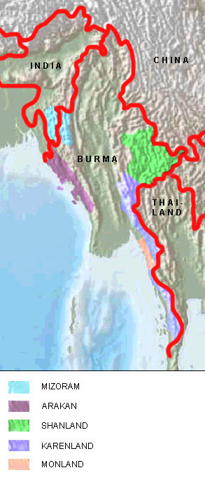
| interaktive Landkarte der separatistischen Gebiete in der Region – clickable map of the separatist areas in the region: |
|
| Quelle/Source: Map is Freeware, University of Texas Libraries, modyfied by: Volker Preuss |