Memelgebiet |
|
|
|
| Übersicht – Contents: | |
Memelgebiet |
|
|
|
| Übersicht – Contents: | |
Memelgebiet – Memel Area: |
|
| Das
Memelgebiet ist ein schmaler Gebietssteifen nördlich des Flusses Memel mit
einer Gesamtfläche von 2 416 km². Es gehörte seit 1252 dem Deutschen Orden und wurde 1525 ein Teil Preußens, und gehörte seit 1773 zur Provinz Ostpreußen. Mit dem Inkrafttreten des Versailler Diktats am 01.10.1920 wurde das Memelgebiet von Deutschland abgetrennt und der Verwaltung des Völkerbunds unterstellt. 1922 wurde eine Volksabstimmung durchgeführt, die jedoch nicht die Option einer Wiederangliederung an Deutschland enthielt, sondern nur eine Option zur Schaffung eines Freistaates Memelland. Für diese Alternative sprachen sich aber immerhin 90% der Befragten aus, woraufhin am 10.01.1923 litauische Truppen das Memelgebiet besetzten. Der Völkerbund akzeptierte diesen Gewaltakt und erließ am 08.05.1924 die "Memelkonvention", mit der das Memelgebiet als autonomes Gebiet Litauen angegliedert wurde. In Folge einer vertraglichen Regelung zwischen dem Deutschen Reich und Litauen wurde das Memelgebiet am 22.03.1939 an das Deutsche Reich zurückgegeben und wieder der Provinz Ostpreußen eingegliedert. Im Januar 1945 wurde das Memelgebiet von russischen Truppen besetzt und seit dem 07.04.1948 von Sowjet-Litauen verwaltet. |
The Memel area is a narrow stripe of territory northern of the river Memel with a whole area of 933 square miles. Since 1252 it belonged to the Order of the Teutonic Knights and became in 1525 a part of Prussia, and belonged since 1773 to the Province of East Prussia. With the came into force of the Versaille diktat on the 1st of October in 1920 got the Memel area separated from Germany and subordinated under the administration of the League of Nations. In 1922 was performed a plebiscite, wich however not contained the option of a re-affiliation to Germany, but only one option to a creation of a Free State of Memelland. For this option voted nevertheless 90% of the consulted people whereupon Lithuanian squads occupied the Memel area on the 10th of January in 1923. The League of Nations accepted this use of force and passed the "Memel convention" on the 8th of May in 1924, wherewith the Memel area became affiliated to Lithuania as an autonomous territory. As a result of a treaty between the German Empire and Lithuania the Memel area became given back to the German Empire on the 22nd of March in 1939, and incorporated to the Province of East Prussia again. In the January of 1945 the Memel area got occupied by Russian military and is administrated from Soviet-Lithuania since the 7th of April in 1948. |
| Quelle/Source: Volker Preuß | |
Flaggen – Flags: |
|
 |
bis/to 1920,
|
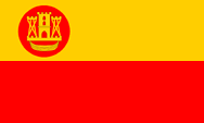 |
1920–1939,
|
|
|
|
Bedeutung/Ursprung der Flagge – Meaning/Origin of the Flag: |
|
| Das
Memelgebiet wurde am 01.10.1920 mit dem Inkrafttreten des Versailler Diktats
von Deutschland abgetrennt und unter die Verwaltung des Völkerbunds
gestellt. Vorher gab es kein "Memelgebiet", denn das Land
gehörte zu Ostpreußen und war in dessen Kreisstrukturen eingegliedert. |
The Memel Area wurde was separated from Germany on the 1st of October in 1920 when the Versailles Dictate came into force and subordinated under the administration of the League of Nations. Before there was not a "Memel Area", because the region belonged to East Prussia and was incorporated into its administrative districts structures. Therefore the Memel Area never had – so long as it belonged to the Prussian Province of East Prussia – an own flag. |
| Es kursieren im Gegensatz dazu Abbildungen von schwarz-weiß-schwarzen Flaggen mit der Inschrift "Memel". Diese gehen auf eine Regelung zurück, in der es preußischen Küstenschiffern vorübergehend erlaubt war ihren Heimathafen in den weißen Streifen der preußischen Flagge zu schreiben. Von daher können diese Flaggen unmöglich mit dem Memelgebiet in Verbindung gebracht werden. | There
circulate in difference to that reproductions of black-white-black flags
with the inscription "Memel". This goes back to a law in which it Prussian inshore skippers was temporarily allowed to write their home port into the white stripe of the Prussian flag. Therefore, these flags, impossibly can not bee seen in context with the Memel Area. |
| Ab dem 01.10.1920 wurde für das als politische Struktur neu geschaffene Memelgebiet eine eigene Flagge eingeführt. Sie war längsgestreift und zeigte zwei Streifen in Gelb und Rot, die Farben der Stadt Memel, und in der Oberecke nahe dem Mast das Stadtwappen von Memel in einer roten Scheibe. Die Farben Grün, Weiß und Rot, die manchmal mit dem Memelgebiet in Verbindung gebracht werden, sind die Farben der litauischen Minderheit im Lande. | On the 1st of October in 1920 was introduced for the as political structure new created Memel Area an own flag. It was lengthwise striped and showed two stripes in yellow and red – the colours the Memel Town – and in the upper staff quadrand near the pole the coat of arms of Memel Town within a red disk. The colours green, white and red, which are sometimes associated with the Memel Area, are the colours of the Lithuanian minority in the country. |
| Quelle/Source: Volker Preuß | |
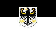
Wappen – Coat of Arms: |
|
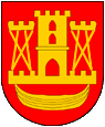 |
Wappen von Memel – coat of arms of Memel |
|
|
|
Bedeutung/Ursprung des Wappens – Meaning/Origin of the Coat of Arms: |
|
| Mit der Abtrennung von Preußen, und der Unterstellung unter die internationale Verwaltung (Frankreich, Großbritannien, Italien und Japan), wurde das Wappen der Stadt Memel als Wappen für das Memelgebiet eingeführt. | In
context with the separation from Prussia and the subordination under the
international administration (France, Great Britain, Italy and Japan) was
introduced the coat of arms of Memel Town as that for the Memel Area. |
| Quelle/Source: Volker Preuß | |
Zahlen und Fakten – Numbers and Facts: |
|
|
|
|
|
|
|
|
|
|
|
|
Geschichte: |
|
1252
· Gründung der "Mummelburg" durch den Deutschen Orden 1257 · Stadtrecht 1328 · Einrichtung einer Komturei des Deutschen Ordens, das Memelland wird damit aus der Livländischen Ordensprovinz ausgegliedert und der Verwaltung der Preußischen Ordensprovinz unterstellt 1525 · Teil Preußens 1773 · zur preußischen Provinz Ostpreußen 01.10.1920 · Inkrafttreten des Versailler Diktats: Abtrennung des Memelgebiets von Deutschland, Unterstellung unter die Verwaltung des Völkerbunds 1922 · Volksabstimmung (90% Ja-Stimmen) für Schaffung eines Freistaates Memelland 10.01.1923 · Besetzung des Memelgebiets durch litauische Truppen 08.05.1924 · der Völkerbund beschließt die "Memelkonvention" (Anschluss des Memelgebiets an Litauen als autonomes Gebiet) 1926 bis 1938 · Litauen verhängt das Kriegsrecht über das Memelgebiet 22.03.1939 · vertragliche Regelung zwischen dem Deutschen Reich und Litauen: das Memelgebiet wird an das Deutsche Reich zurückgegeben und der Provinz Ostpreußen eingegliedert Januar 1945 · Zweiter Weltkrieg: Besetzung des Memelgebiets durch sowjetischen Truppen 07.04.1948 · Unterstellung des Memelgebietes unter die Verwaltung von Sowjet-Litauen |
History: |
|
1252
· foundation of the "Mummelburg" by the Order of the German Knights 1257 · city law 1328 · establishment of a governmental subsidiary of the Order of the German Knights, the Memelland is in this way excorporated from the Livonian order's province and subordinated under the government of the Prussian order's province 1525 · part of Prussia 1773 · to the Prussian Province of East Prussia 1st of October 1920 · coming into force of the Versailles Dictate: separation of the Memel Area from Germany, subordination under the administration of the League of Nations 1922 · plebiscite (90% yes-votes) for the creation of a Free State of Memelland 10th of January 1923 · occupation of the Memel Area by Lithuanian troops 8th of May 1924 · the League of Nations passes the "Memel Convention" (annexion of the Memel Area by Lithuania as autonomous territory) 1926 to 1938 · Lithuania imposes the war law over the Memel Area 22nd of March 1939 · conventional determination between the German Empire and Lithuania: the Memel Area becomes given back to the German Empire and incorporated the Province of East Prussia January 1945 · Second World War: occupation of the Memel Area by soviet troops 7th of April 1948 · subordination of the Memel Area under the administration of Soviet Lithuania |
| Quelle/Source: Wikipedia (D) |
Ursprung des Landesnamens – Origin of the Country's Name: |
|
| Als im
Jahre 1252 die "Mummelburg" gegründet wurde, war wahrscheinlich der gut 40
km entfernte Fluss Memel der Namensgeber. Das Memelgebiet selbst liegt
jedoch zwischen der Stadt Memel und dem Fluss Memel. Die Stadt Memel heißt auf Litauisch "Klaipeda", und der Fluss Memel "Nemunas". |
As in 1252 the "Mummelburg" was build the about 40 kilometers distant Memel River probably was the names patron. But the Memel Area itself is positioned between Memel Town and Memel River. Memel Town is called "Klaipeda" in Lithuanian language and Memel River is called "Nemunas". |
| Quelle/Source: www.geschichtsverein-international.de | |
![]()
![]()
![]()
![]()
![]()