Saarland |
|
|
|
| Übersicht – Contents: | |
Saarland |
|
|
|
| Übersicht – Contents: | |
Flaggen – Flags: |
|
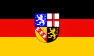 |
seit/since 1957, Landesflagge – flag of the country, Quelle/Source nach/by: Wikipedia (D)
|
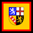 |
Flagge des Ministerpräsidenten – flag of the Premier, Quelle/Source nach/by: Wikipedia (D)
|
|
|
|
historische Flaggen – historic Flags: |
|
 |
1920–1935, Flagge unter französischer Verwaltung im Auftrag des Völkerbundes – flag under French government in the behalf of the League of Nations, Quelle/Source nach/by: Wikipedia (D)
|
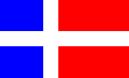 |
1948–1956, Flagge des (teil)autonomen Saarlandes – flag of the partly autonomous Saarland, Quelle/Source nach/by: Wikipedia (D)
|
|
|
|
Bedeutung/Ursprung der Flagge – Meaning/Origin of the Flag: |
|
| Die heutige Flagge des Saarlandes wurde am 01.01.1957 mit dem Beitritt zur Bundesrepublik Deutschland angenommen. Sie zeigt die deutsche Trikolore mit dem Landeswappen in der Mitte. Als Saargebiet unter Völkerbundregierung (1919–1935) führte das Land eine blau-weiß-schwarze Trikolore, deren Farben dem damaligen Wappen entlehnt waren. Des (teil)autonome Saarland führte zwischen dem 16.07.1948 und dem 31.12.1956 eine blau-rote Flagge mit einem weißen skandinavischen Kreuz. | The
todays flag of the Saarland was adoped on 1st of January in 1957 in context
with the joining to the Federal Republic Germany. It shows the german
tricolor with the coat of arms of the country in the middle. As Saar Area – under French government in the behalf of the League of Nations (1919-1935) – the country used blue-white-black tricolor. Its colours came from the then coat of arms. The partly autonomous Saarland used between 1947 and 1957 a blue-red flag with a white Scandinavian cross. |
| Quelle/source: Volker Preuß, Die Welt der Flaggen | |
Wappen – Coat of Arms: |
|
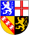 |
seit/since 1957, Wappen des Saarlandes – coat of arms of the Saarland, Quelle/Source nach/by: Wikipedia (D) |
 |
seit/since 2005 Saarland-Zeichen (Landessymbol) – Saarland Sign (Symbol, Logo), Quelle/Source: www.saarland.de / Public domain, Wikipedia (D) |
 |
1948–1956, Wappen des (teil)autonomen Saarlandes – coat of arms of the partly autonomous Saarland, Quelle/Source nach/by: Wikipedia (D) |
 |
1946–1947, Wappen des Saargebiets unter französischer Besetzung – coat of arms of Saar Area under French occupation, Quelle/Source nach/by: Der Michel |
 |
1920–1935, Wappen unter französischer Verwaltung im Auftrag des Völkerbundes – coat of arms under French government in the behalf of the League of Nations, Quelle/Source nach/by: Wikipedia (D) |
Bedeutung/Ursprung des Wappens – Meaning/Origin of the Coat of Arms: |
|||||||||
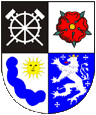
| Das Wappen des Saargebiets unter französischer Verwaltung im Auftrag des Völkerbundes (seit dem 20.01.1920) wurde am 28.07.1920 durch die internationale Regierungskommission eingeführt. Es war eine Kombination aus Teilen mehrerer Stadtwappen, und zeigte im ersten Feld ein silbernes Grubenrad mit gekreuztem Hammer und Schlägel auf schwarzem Grund (Stadt St. Ingbert), im zweiten Feld eine rote Rose auf silbernem Grund (Stadt St.Johann), im dritten Feld eine goldene Sonne über einer blauen Wolke auf silbernem Grund (Stadt Saarlouis), und im vierten Feld einen silbernen Löwen und vier silberne Tatzenkreuze auf blauem Grund (Stadt Saarbrücken). | The coat
of arms of the Saar Area under French government in the behalf of the League
of Nations (since the 20th of January in 1920) was introduced by the
international governmental commission on the 28th of July in 1920. It was a combination from parts of several town's scutcheons and showed in the first field a silvery mine-wheel with crossed hammer and mallet on black ground (City of St. Ingbert), in the second field a red rose on silvery ground (City of St.Johann), in the third field a golden sun above a blue cloud on silvery ground (City of Saarlouis), and in the fourth field a silvery lion and four silvery paw-crosses on blue ground (City of Saarbruecken). |
||||||||
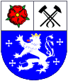
| Als das
Saarland als eigene Verwaltungseinheit am 18.07.1946 aus der französischen
Besatzungszone ausgegliedert wurde, hat man zunächst das Stadwappen von
Saarbrücken, in einer etwas abgewandelten Form für das Saarland verwendet: Dieses Wappen war halbgespalten und geteilt, und zeigte im ersten Feld eine rote Rose auf silbernem Grund (Stadtteil St. Johann), im zweiten Feld Hammer und Schlägel gekreuzt, kombiniert mit einer nach unten zeigenden schwarzen Zange alles auf silberem Grund (Stadtteil Malstatt - Burbach), und im dritten (unteren) Feld ein silberner Löwe und vier silberne Tatzenkreuze. Der eigentlich zum Saarbrücker Stadtwappen gehörende schwarz und silbern gestückte Schildrand wurde bei diesem Wappen jedoch weggelassen. |
As the
Saarland was separated from the French Occupation Zone as an own
governmental on the 18th of July in 1946, was the scutcheon of Saarbruecken
initially in use for the Saarland, however in a some changed type: Those coat of arms was half clefted and divided and showed in the first field a red rose on silvery ground (quarter St. Johann), in the second field two crossed hammers combined with a down pointing black tong everything on silvery ground (quarter Malstatt - Burbach), and in the third (lower) field a silvery lion and four silvery paw-crosses. The actually to the coat of arms of Saarbruecken belonging black and silvery pieced shield border was however leaved out at this coat of arms. |
||||||||
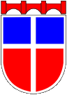
| Nach der Einführung der Verfassung wurde am 14.12.1948 per Gesetz ein neues Wappen für das Saarland eingeführt. Dieses Wappen war aus einem Wettbewerb hervorgegangen. Es orientierte sich an der Gestaltung der als Banner gehissten Landesflagge, jedoch mit einem schmalen silbernen Schildrand. Das Schild trug eine rote Brückenkrone. | After the introduction of the constitution was inctoduced a new coat of arms for Saarland on 14th of December in 1948 per law. Those coat of arms arised out of a competition. It was orientated in the designing of the as banner hoisted flag of the country, however with a narrow silvery shield border. The shield carryed abov a red bridge-crown. | ||||||||
| Das heutige, am 01.01.1957 eingeführte Landeswappen zeigt die heraldischen Symbole ehemaliger Landesteile: Grafschaft Saarbrücken - Commercy (weißer Löwe auf hellblauem Grund mit neun weißen Fußspitztatzenkreuzen), Kurfürstentum Trier (rotes geschliffene Balkenkreuz auf silbernem Grund), Herzogtum Lothringen (roter Schrägbalken mit drei gestümmelten silbernen Adlern – Alérions genannt – auf goldenem Grund) und Herzogtum Pfalz-Zweibrücken (goldener Löwe auf schwarzem Grund). | The
today's (on the 1st of January in 1957 introduced) coat of arms shows the
heraldic symbols of former country's parts: County of Saarbruecken (white lion on light-blue ground with nine white sharp-foot paw-crosses), Electorate of Trier (red sharpend bar-cross on silvery ground), Duchy of Lothringen (red diagonal bar with three crippled silvery eagles – named Alérions – on golden ground) and Duchy of Palatinate-Zweibruecken (golden lion on black ground). |
||||||||
| Die Nutzung des Wappens ist Ämtern und Behörden des Landes vorbehalten. Für die private Nutzung gibt es seit 2005 das Saarland-Zeichen. Es darf von jedermann verwendet, jedoch nicht verändert werden. | The use
of the coat of arms is reserved for offices and authorities of the
country. The Saarland Sign is since 2005 available for private use.
It can be used by everyone, but its not allowed to change it.
|
Quelle/source:
Volker Preuß,
Wikipedia (D),
Der Michel,
www.saarland.de
| |
Lesen Sie hier: |
Hintergründe, Geschichte und Fakten zum Thema "Der Löwe in der Heraldik". Ausführungen, Varianten, Entwicklung sowie Panther und Leoparden.
|
 | ||||
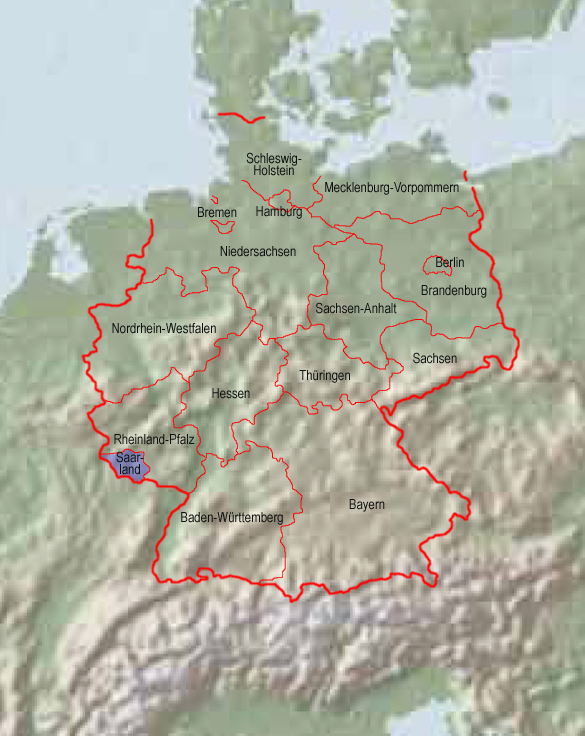
Landkarte – Map: |
| Die BRD und ihre Länder, interaktive Karte
– FRG and its countries, clickable map: |
|
Zahlen und Fakten – Numbers and Facts: |
|
|
|
|
|
|
|
|
|
|
|
|
|
|
Geschichte: |
||
|
1920 · gemäß den Festlegungen des Versailler Diktats
wurde das aus preußischen und bayerischen Landesteilen gebildete
Saargebiet dem Völkerbund unterstellt, und in dessen Auftrag von
Frankreich verwaltet. Die Kohlegruben wurden Frankreich übereignet. 1935 · nach einer Volksabstimmung (90% für Deutschland) Rückgliederung des Saargebiets in das Deutsche Reich 1945 · französische Besetzung, das Saarland kommt zur französischen Besatzungszone (FBZ) 18.07.1946 · Vergrößerung des Saarlands um 888 km², Ausgliederung des Saarlands aus der FBZ und Eingliederung in das französische Zoll- und Währungsgebiet 08.06.1947 · teilweise Rückgängigmachung der Gebietserweiterungen (ca. 40%) 17.12.1947 · neue Verfassung, das Saarland wird von Deutschland abgetennt 23.04.1949 · weitere Gebietserweiterungen 23.10.1954 · Saarstatut, geplante Festschreibung der Abtrennung des Saarlands von Deutschland, jedoch nach Volksabstimmung 23.10.1955 · Volksabstimmung, das Saarstatut wird mit 67,7% abgelehnt 27.10.1956 · Saar-Vertrag 01.01.1957 · Beitritt des Saarlands zur BRD 06.07.1959 · wirtschaftliche Vereinigung des Saarlands mit der BRD (Währungs- und Zollunion) |
||
History: |
||
|
1920 · In accordance with the arrangements of the
Versailles Dictate gets the from Prussian and Bavarian territories
existing Saar region subordinated under the League of Nations, and in its
orders administered by France. The coal mines
were bequeathed to France. 1935 · after a plebiscite (90% for Germany) re-affiliation of the Saar region to the German Empire 1945 · French occupation, the Saarland comes to the French Occupation Zone (FOZ) 18th of July in 1946 · expansion of the Saarland by 343 sq.m., separation fo the Saarland from the FOZ and incorporation to the French customs and currency zone 8th of June in 1947 · partial cancellation of the expansions (ca. 40%) 17th of December in 1947 · new constitution, the Saarland gets separated from Germany 23rd of April in 1949 · further expansions of territory 23rd of October in 1954 · Saar Statute, planned fixing of the separation of the Saarland from Germany, however after a plebiscite 23rd of October in 1955 · plebiscite, the Saar Statute gets rejected by 67,7% 27th of October in 1956 · Saar Treaty 1st of January in 1957 · joining of the Saarland to the FRG 6th of July in 1959 · economical unification of the Saarland with the FRG (currency and customs union) |
||
Quelle/Source:
Atlas zur Geschichte,
Wikipedia (D)
| Surftipp für mehr
Informationen: www.saar-nostalgie.de |
|
Ursprung des Landesnamens – Origin of the Country's Name: |
|
| Der Name des Landes geht auf den Fluss "Saar" (frz. Sarre, lat. Saravus) zurück, der das Land im Westen von Süden nach Norden durchfließt. Seine Quelle liegt im Elsass. | The name of the country goes back to the river "Saar" (French: Sarre, Latin: Saravus), which flows through the country in the west from south to north. Its source is in Elsass (Alsace). |
| Quelle/Source: Volker Preuß | |
![]()
![]()
![]()
![]()
![]()
|
Mit freundlicher Untersützung von: Kindly supported by: |
Joachim Schepp |