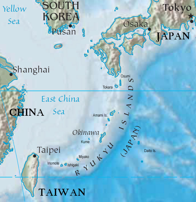
Okinawa |
|
|
|
| Übersicht – Contents: | |
Okinawa |
|
|
|
| Übersicht – Contents: | |
| Der
Begriff "Okinawa" ist der Name der größten Insel einer Inselgruppe, die
zwischen Japan und Taiwan liegt. Auf japanisch wird diese Inselgruppe
"Nansei-Shoto" genannt. Auf diesen Inseln bildete sich ab dem 12. Jahrhundert ein Staat, der Königreich Ryukyu hieß, und so übertrug sich der Name Ryukyu auf die ganze Inselgruppe, die bis heute (außerhalb Japans) Ryukyu-Inseln genannt wird. Als der japanische Staat im Jahre 1879 die Inseln endgültig in seinen Besitz brachte, wurde auf den Ryukyu-Inseln die Präfektur Okinawa errichtet, benannt nach der größten Insel. Die Inseln wurden im Zweiten Weltkrieg anstelle Japans durch US-Truppen besetzt, einer US-Militärverwaltung unterstellt und es wurden Militärstützpunkte errichtet. Die Amami-Inseln wurden 1953 an Japan zurückgegeben und an die Präfektur Kagoshima angeschlossen. |
The term
"Okinawa" is the name of the largest island in an archipelago that lies
between Japan and Taiwan. In Japanese, this archipelago is called "Nansei-Shoto". On these islands formed from the 12th century a state, the Kingdom of Ryukyu, and in this way the name Ryukyu was transferred to the entire archipelago, known until today (outside of Japan) as Ryukyu Islands. When the Japanese government in 1879 finally brought the islands into his possession, on the Ryukyu Islands was established the Okinawa Prefecture, named after the largest island. The islands were occupied during World War II by U.S. forces, instead of Japan , an U.S. military administration was established and there were built military bases. The Amami Islands were returned to Japan in 1953 and became connected to the Kagoshima Prefecture. |
| Quelle/Source: Volker Preuß | |
Flagge – Flag: |
|
 |
Flagge der Präfektur Okinawa – Flag of the Prefecture of Okinawa, Seitenverhältnis – ratio = 2:3 Quelle/Source, nach by: Wikipedia (EN)
|
historische Flaggen – historical Flags: |
|
 |
19. Jahrhundert/19th century, Handelsflagge des Königreiches Ryukyu – merchant flag of the Ryukyu Kingdom, (?) Quelle/Source: Flags of the World |
 |
bis/to 1875, Flagge des Königreiches Ryukyu – Flag of the Ryukyu Kingdom, Quelle/Source, nach by: Wikipedia (EN)
|
 |
1875–1879, Flagge des Königreiches Ryukyu – Flag of the Ryukyu Kingdom, Quelle/Source, nach by: Flags of the World
|
 |
1950, Flagge des geplanten Unabhängigen Staates Okinawa – Flag of the purposed Independent State of Okinawa, Seitenverhältnis – ratio = 2:3 Quelle/Source, nach by: Flags of the World
|
 |
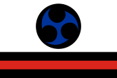
1950–1967, |
  |
1967–1972,
|
andere Flaggen – other Flags: |
|
 |
Flagge der Ryukyu Independent Party (Kariyushi Club) – Flag of the Ryukyu Independent Party (Kariyushi Club), Seitenverhältnis – ratio = 2:3 Quelle/Source, nach by: Flags of the World
|
 |
Flagge der Okinawa Independence Party |
 |
inoffizielle Flagge von Okinawa – unofficial flag of Okinawa, Seitenverhältnis – ratio = 2:3, Quelle/Source, nach by: Flags of the World
|
Bedeutung/Ursprung der Flagge – Meaning/Origin of the Flag: |
|
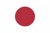
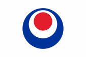
| Die offizielle Flagge der Präfektur Okinawa wurde 1972 eingeführt. Sie zeigt ein weißes Flaggentuch mit einem für japanische Flaggen typischen Piktogramm in der Mitte, das aus konzentrischen dunkelroten Kreisen gebildet wird, die ein wenig nach oben verschoben sind. Angeblich soll das Bild den Buchstaben "O" darstellen, den Anfangsbuchstaben des Landes. Der innere rote Kreis soll Okinawa selbst darstellen, der äußere rote Kreis das die Inseln umgebende Meer. | The
Official Flag of the Okinawa Prefecture was introduced in 1972. It shows a
white bunting with a typical Japanese piktogram in the center, which is
formed by concentric dark red circles, shifted slightly upward. Supposedly the picture represents the letter "O", the first letter of the country's name. The inner red circle should represent Okinawa itself, the outer red circle the sea, which surrounds the islands. |
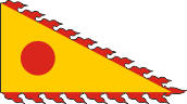
| Da die Geschichte Okinawas als Königreich Ryukyu beginnt, existierten hier vorher natürlich eigene Flaggen. Als erstes wurde am Anfang des 19. Jahrhunderts eine dreieckige gelbe Flagge mit einer roten Scheibe darin erwähnt, die an ihren Rändern kleine rote Zacken zeigte. Sie soll von Handelsschiffen verwendet worden sein, die chinesische Häfen anliefen. Das Königreich Ryukyu wurde bis ins 19. Jahrhundert hinein von China beansprucht , und es wurden auch Tribute an China gezahlt. So ist das chinesische Design dieser Flagge zu erklären. | Because
the history Okinawa of begins as Kingdom of Ryukyu, here of course existed
own flags before. The first in the early 19th century mentioned flag was a
triangular yellow flag with a red disc in the middle, which showed little
red spikes on its edges. It was allegedly used by merchant ships, which
aimed Chinese ports. The Ryukyu Kingdom was claimed by China until the 19th century, and there were even paid tributes to China. Thus, the Chinese design of this flag is to be explained. |
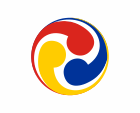
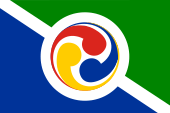
| Mit der allmählichen Zurückdrängung des chinesischen Einflusses und dem wachsenden japanischen Einfluss wurden die Flaggen des Königreichs Ryukyu im 19. Jahrhundert weiß und zeigten ein rundes Symbol aus drei miteinander verschlungenen Elementen, das ab 1875 farbig dargestellt wurde. Mit der Absetzung des Königs durch Japan und der Angliederung des Landes an den Japanischen Staat endete die Geschichte der Flaggen von Ryukyu. | With the
gradual suppression of the Chinese influence and the growing Japanese
influence, the flags of the Kingdom of Ryukyu became white in the 19th
century and they showed a round symbol of three intertwined elements, which
was shown in color from 1875. With the overthrow of the king by Japan and the annexation of the country to the Japanese state the history of the flags of Ryukyu ended. |
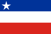
| Nach dem Zweiten Weltkrieg und der Besetzung durch US-Truppen gab es auf den Ryukyu-Inseln Bestrebungen einen eigenen Staat wiederzubeleben, und es wurde im Januar 1950 eine dreistreifige Flagge in den Farben Blau, Weiß und Rot vorgeschlagen, die im blauen Feld - nahe am Mast - einen weißen Stern zeigte. Diese Ambitionen wurden von den USA jedoch nur bis März 1950 unterstützt. Die Flagge fand auch in der Bevölkerung keinen Anklang und wurde nie eingeführt. | After the
Second World War and the occupation by U.S. troops, on the Ryukyu Islands
appeared efforts to revive their own state, and in January 1950 was proposed
a three striped flag in the colors blue, white and red, and in the blue
stripe - close to the mast - was showed a white star. These ambitions were, however, only supported by the USA until March 1950. The flag was not well received by the population and was never introduced. |
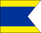
| Da die Inseln der US-Militärverwaltung unterstellt waren, und nicht mehr zu Japan gehörten, musste dennoch eine eigene Flagge eingeführt werden, vor allem für die Küstenschifffahrt bestimmt war, um die einheimischen Schiffe zu kennzeichnen. Es wurde eine zum Schwalbenschwanz eingeschnittene Variante der Flagge "D" des internationalen Signalflaggenalfabets gewählt. Die Benutzung der japanischen Flagge wurde verboten. | As the
islands were subordinated under the U.S. military administration, and
belonged no longer to Japan, there had its own flag to be introduced, needed
mainly for the coastal shipping, to mark the native vessels. They chose a to a dovetail cuted variant of the flag "D" out of the international alphabet of signal flags. The use of the Japanese flag was banned. |
| Ab 1967 durfte wieder die japanische Flagge verwendet werden, jedoch bis 1972 ergänzt um einen kleinen weißen Wimpel mit dem Wort "Ryukyus" in roter, japanischer und lateinischer Inschrift. | From 1967 it was allowed to use the Japanese flag again, but until 1972 added by a small white pennant with the word "Ryukyu" in red, Japanese and Latin inscription. |
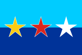
| Auf Grund der eigenständigen Geschichte und Kultur der Inseln und der in der Vergangeheit praktizierten aggressiven japanischen Politik, gibt es noch immer Bestrebungen den Staat Ryukyu wiederzubeleben. Solche Ideen werden von etwa 25% der Bevölkerung unterstützt. Diese Teile der Bevölkerung zeigen gerne eine der Flagge der Präfektur Okinawa ähnliche Flagge, welche die Farben Blau, Weiß und Rot zeigt. Diese Flagge hat große Bedeutung im Kampfsport (Okinawa gilt als das Ursprungsland von Karate), und das Symbol im Farbdreiklang aus Blau, Weiß und Rot soll älter sein als die heutige Flagge der Präfektur. Jene stammt aus dem Jahr 1972 und ihr wird nachgesagt, sie orientiere sich an der japanischen Flagge und stehe somit für die Zeit der Unterdrückung von Kultur und Sprache von Ryukyu/Okinawa. Die Präfektur soll versucht haben die blau-weiß-rote Flagge als Symbol der Präfektur zu übernehmen, jedoch drohte eine Kampfkunstorganisation mit einer Klage. | Due to
the special history and culture of the islands and the in the past practiced
aggressive Japanese policy, there are still exist efforts to revive the
State of Ryukyu. These ideas are supported by about 25% of the population. These parts of the population love it to show a nearly
similar variant of the flag of Okinawa Prefecture, which shows the colors blue,
white and red. That dates from 1972 and is said to be based on the Japanese flag and thus stands for the period of suppression of Ryukyu/Okinawa culture and language. The prefecture is said to have tried to adopt the blue, white and red flag as the prefectural symbol, but a martial arts organization threatened to sue. |
| Interessant sind auch die Flaggen der Okinawa Independence Party und des Kariyushi Clubs, der sich bis 2008 Ryukyu Independent Party nannte. | Also interesting are the flags of the Okinawa Independence Party and of the Kariyushi Club who called himself until 2008 Ryukyu Independent Party. |
| Quelle/Source: Flags of the World, Wikipedia (EN), Volker Preuß | |
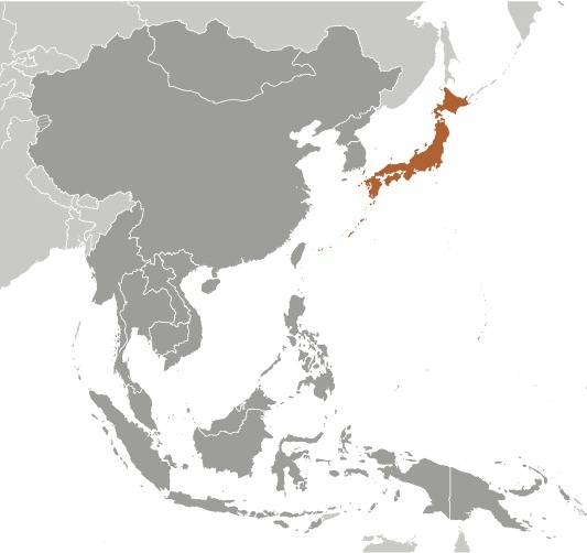
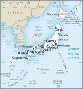
Landkarten – Maps: |
Lage – Position: |
Landkarte des Landes – Map of the Country: |
Landkarte der Ryukyu-Inseln – Map of the Ryukyu Islands: |
Zahlen und Fakten – Numbers and Facts: |
|
|
|
|
|
|
|
|
|
|
|
|
|
|
|
|
|
|
|
|
Geschichte: |
|
ca 30000 v.Chr.
· Besiedlung durch den Yamashita-Höhlenmensch ab 2000 v.Chr. - 12. Jhd. n.Chr. · Entwicklung zweier Kulturen, Herausbildung von Fürstentümern, Kontakte nach Japan 12. Jhd. · Einigung einiger Fürstentümer unter Shunten Aji 14. Jhd. · Regentschaft des Königs Satto, Kontakte nach Korea, Japan und China 1372–1439 · Regentschaft von König Sho Hashi, vollständige Einigung des Königreichs Ryukyu, Gründung der Sho-Dynastie 1477–1526 · Regentschaft von König Sho Shin, Entmachtung der lokalen Fürsten, Errichtung einer Zentralverwaltung, an China werden Tribute gezahlt 1609 · Satsuma-Invasion durch Japan, Ryukyu wird zusätzlich von Japan abhängig, die Anami-Inseln werden abgetreten 1853 · der US-amerikanische Seefahrer Matthew Perry errichtet auf Okinawa eine Kohlestation 1871 · Japan übernimmt die Verwaltung und gliedert die Ryukyu-Inseln in die Präfektur Kagoshima ein 1874 · Taiwan-Expedition Japans, China erkennt die japanischen Herrschaft über die Ryukyu-Inseln an 1878 · der Kaiser des Deutschen Reiches, Wilhelm I., lässt auf der Insel Miyako ein Denkmal errichten 1879 · Entthronung des Königs durch Japan, Gründung der Präfektur Okinawa, Abtretung der Yaeyama-Inseln (Ishigaki und Iriomote) und der Insel Miyako an China 1894–1895 · Sieg Japans im Chinesisch-Japanischer Krieg, Yaeyama und Miyako werden der Präfektur Okinawa angegliedert April–Juni 1945 · Schlacht um Okinawa im Zweiten Weltkrieg, Invasion US-amerikanischer Truppen, alle Ryukyu-Inseln südlich des 29. Breitengrads werden durch US-amerikanische Truppen besetzt und einer Militärverwaltung unterstellt, Errichtung von US-Militärstützpunkten 08.09.1951 · der Vertrag von San Francisco, Japan erhält sein Selbstbestimmungsrecht zurück, Regelung des Status der Ryukyu-Inseln 1953 · Rückgabe der Amami-Inseln an Japan, Angliederung an die Präfektur Kagoshima 1972 · Rückgabe der Präfektur Okinawa von den USA an Japan, die US-Militärstützpunkte bleiben bis heute bestehen (auf ca 15% der Fläche der Insel Okinawa) |
History: |
|
about 30000 B.C. · settlement by the Yamashita-cavemen from 2000 B.C. to 12th century A.D. · development of two cultures, formation of principalities, contacts to Japan 12th century · unification of some principalities under Shunten Aji 14th century · reign of King Satto, contacts to Korea, Japan and China 1372-1439 · reign of King Sho Hashi, complete unification of the Kingdom of Ryukyu, establishing of the Sho-Dynasty 1477-1526 · reign of King Sho Shin, disempowerment of local rulers, establishment of a central government, pay of tributes to China 1609 · Satsuma-Invasion by Japan, Ryukyu becomes also dependent on Japan, the Anami Islands become ceded 1853 · The U.S. sailor Matthew Perry builts a coal station in Okinawa 1871 · Japan took over the administration, annexation of the Ryukyu Islands to the Kagoshima Prefecture 1874 · Taiwan-Expedition of Japan, China recognizes the Japanese sovereignty over the Ryukyu Islands 1878 · the Emperor of the German Empire, Wilhelm I., erects a monument on Miyako Island 1879 · dethronement of the King by Japan, establish of the Okinawa Prefecture, cede of the Yaeyama Islands (Ishigaki and Iriomote) and of Miyako Island to China 1894–1895 · Japanese victory in the Sino-Japanese War, Yaeyama and Miyako become affiliated to the Okinawa Prefecture April–June 1945 · Battle of Okinawa during World War II, invasion of U.S. troops, all Ryukyu Islands south of the 29th latitude become occupied by U.S. troops and subordinated under a military administration, establishment of U.S. military bases 8th of September in 1951 · Treaty of San Francisco, Japan regains his self-determination, regulation of the status of the Ryukyu Islands 1953 · return of the Amami Islands to Japan, annexation to the Kagoshima prefecture 1972 · return of Okinawa from USA to Japan, the U.S. bases remain until today (at about 15% of the area of the island of Okinawa) |
| Quelle/Source: Wikipedia (D) |
Ursprung des Landesnamens – Origin of the Country's Name: |
|
| Das Wort "Okinawa" besteht aus den Bestandteilen "Oki" und "Nawa". Diese beiden japanischen Worte bedeuten "offenes Meer" und "Kette", und beschreiben so die Anordnung und Lage der Inseln. | The word "Okinawa" is composed of the elements "Oki" and "Nawa". These two Japanese words mean "open sea" and "chain", and describe in this way the arrangement and location of the islands. |
| Quelle/Source: Handbuch der geographischen Namen | |
|
Mit freundlicher Untersützung von: Kindly supported by: |
Maria Gürth und Stanislaw Meyer |