mobile View, to the German Version tap the flag


- Autonomous District of Chukotka
- federal component of the Russian Federation (Russia)
- own names:
- Chukchi: Chukotkaken Avtonomnyken Okrug
- Russian: Chukotski Avtonomny Okrug
• Flag
• Historical Flags
• Meaning/Origin of the Flag
• Coat of Arms
• Meaning/Origin of the Coat of Arms
• Map
• Numbers and Facts
• History
• Origin of the Country's Name
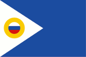
since 2007,
Flag of the district,
ratio = 2:3,
Source, by:
Flags of the World


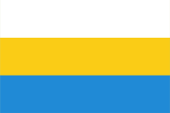
1921–1922, Free State of Chukotka,
Flag of the free state,
ratio = 1:2,
Source, by:
Wikipedia (RU)

1994–1997,
Flag of the district,
ratio = 1:2,
Source, by: Flags of the World
The flag of Chukotka was introduced on 28th of February in 1994. It was a plain light blue bunting, with an aspect ratio of 1:2, with a white isosceles triangle on the mast that reached to the middle of the flag. Inside the triangle there is a golden bordered disc with the colors of Russia. On 29th of October in 2007 the flag was changed. The aspect ratio was changed from 1:2 to 2:3 and the blue was changed from light blue to dark blue. Blue is the national colour of the Chukchi people. But it also stands for the country's rivers. The white represents the ice and snow that covers the land most of the year. The colour yellow represents sun, hope and friendship. During the Russian Civil War from 1917 to 1922, anti-Bolshevik forces founded the Chukotka Free State in 1921 and from here they tried for some time to resist the establishment of the Soviet dictatorship. The country's flag featured three horizontal stripes of white, gold and light blue. The colors of this flag can be found in today's flag, whether intentionally or unintentionally.
Source:
Wikipedia (EN),
Wikipedia (RU),
Volker Preuß
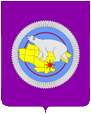
Coat of arms of Chukotka,
Source, by:
Russiatrek
The coat of arms of Chukotka shows a crimson shield. On it, on a pale blue disk, a golden map of the country (a hint to the mineral resources) with a polar bear (a hint to the fauna). A red eighth-pointed star marks on the map the position of the capital Anadyr.
Source: Volker Preuß
Geographical position within Russia:
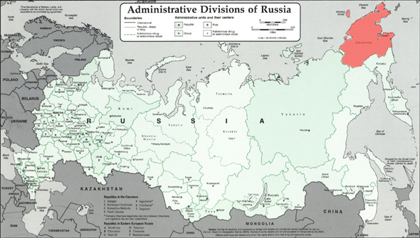
Source: Freeware, russiamap.org, modyfied by: Volker Preuß
enlarge – click or tap here
Map of the country:
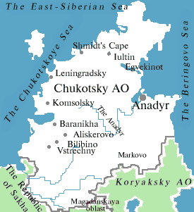
Source: Russiatrek
Area: 278.564 square miles
Inhabitants: 50.500 (2010), thereof 52% Russians, 23% Chukchee, 9% Ukrainians, 3% Eskimo, 2% Evens
Density of Population: 0,18 inh./sq.mi.
Capital: Anadyr (Name to 1923: Nowo-Mariinsk), 13.000 inh. (2010)
official Languages: Russian, Chukchi
other Languages: Ukrainian, Belorussian, Evenian
Currency: Russian currency
Time Zone: from 28th of March 2010, GMT + 12 h; to 28th of March 2010, GMT + 13 h
Source: Wikipedia (DE)
17th century · start of the Russian exploitation in the south of the country
1649 · foundation of Anadyrsk Town (today Markovo) at the Anadyr River
1761/1762 · Russian exploitation of the whole country, attempts to force the Chukch in dependence or to introduce a fur tax fail
1921–1922 · Free State of Chukotka
1923 · establishment of the soviet dictatorship
10th of December 1930 · establishment of the "Autonomous District of the Chukchee"
1931 · introduction of the Chukchee writing diction with cyrillic alphabet
1940–1990 · potent Russian and Ukrainian immigration
31st of December in 1991 · the Soviet Union dissolves, the constitution of the Russian Socialist Federative Soviet Republic (RSFSR, Russia), a former substate of the Soviet Union, remains in force for the time being
25th of December in 1993 · a new constitution for Russia (Russian Federation) comes into force, and the relationships with the members of the federation is re-regulated in this way
since 1995 · because of the decline of mining potent migration of the population (60% until 2008)
Source:
Atlas zur Geschichte,
World Statesmen,
Russiatrek,
Die Völker der Erde,
Wikipedia (D)
The name Chukotka means "Land of the Chukch". But the Chukch call themselves "Chauchu Lygorawetlyan", what means "true human being".
Source:
Die Völker der Erde
Surf Tip: