mobile View, to the German Version tap the flag


- Northern Mariana Islands (Mariana Islands without Guam Island)
- unincorporated territory of the USA
- own name: Commonwealth of the Northern Mariana Islands
• Flag
• Historical Flags
• Meaning/Origin of the Flag
• Coat of Arms
• Meaning/Origin of the Coat of Arms
• Map
• Numbers and Facts
• History
• Origin of the Country's Name
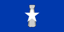
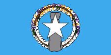
National flag,
ratio = 1:2 (20:39),
Source, by: Wikipedia (EN), commons.wikimedia.org


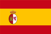
1785–1899,
Flag of Spain,
Source, by: Flags of the World

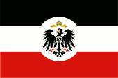
1899–1914,
German Empire,
Official flag of Colonial Office,
ratio = 2:3,
Source, by: Wikipedia (DE)
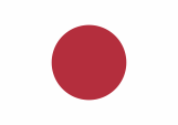
1914–1944,
Flag of Japan,
Source, by: Wikipedia (EN)
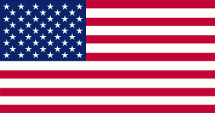
since 1944,
Flag of USA,
ratio = 10:19,
Source, by: Wikipedia (DE)
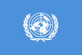
1947–1965,
UN Trust Territory,
Flag of the UNO,
ratio = 2:3,
Source, by:
Wikipedia (EN)
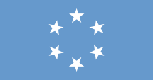
1965–1972,
UN Trust Territory,
Flag of the Pacific Islands,
ratio = 10:19,
Source, by: Flags of the World
1972–1989,
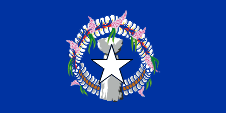
National flag,
ratio = 1:2 (20:39),
Source, by: Wikipedia (EN), Orange Tuesday,
Public domain, via Wikimedia Commons
1989–1991,
National flag,
ratio = 1:2 (20:39),
Source, by: World Statesmen,
Wikipedia (EN), commons.wikimedia.org
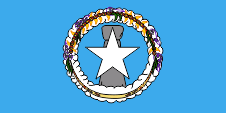
1991–1995,
National flag,
ratio = 1:2 (20:39),
Source, by: World Statesmen,
using commons.wikimedia.org
The first own national flag was created for local purposes in 1972. It was solid blue and featured a white star in front of a latte stone. The side ratio is 20:39, in practice 1:2. The blue stands for the Pacific Ocean and the Mariana Trench, the star for the Northern Mariana Islands, but also for the USA, and the latte stone for the Chamorros. Latte stones, today a sign of Chamorro identity, were used by the Chamorro – indigenous people of the Marianas – as foundation stones for their houses. The shade of the colour blue has not been defined to this day; it was and still is quite different, even after 4th of July in 1976, when the flag was officially approved. In front of offices and authorities, the flag of the USA must also be hoisted. In 1985, the flag was reaffirmed, now by constitution, and its appearance was changed somewhat in 1989: The blue of the flag became lighter and a decorative wreath of flowers and shells (Mwarmwar) was added in the middle. It represents the Carolinian ethnic group. Between 1991 and 1995, the wreath was placed above the latte stone. Since 1995, the flag id displayed in a darker shade of blue and the wreath and stone have probably also been more graphically refined. The flag of the UN Trust Territory "Pacific Islands" was also solid blue. It showed six stars. These stood for Palau, Yap, Truk, Ponape, the Marshall Islands and the Marianas.
Source: 1.) Wikipedia (D), 2.) Wikipedia (EN)
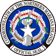
Seal of the Northern Mariana Islands,
Source:
CoA: File:Flag of the Northern Mariana Islands.svg
(Open Clip Art Library)User:Connormah,
Public domain, via Wikimedia Commons
The Northern Marians use a seal. It is unknown when it was put into service. It displays the image of the flag surrounded by an inscription. That shows the name of the country in the upper part: "Commonwealth of the Northern Mariana Islands".
Source: Volker Preuß
Location:
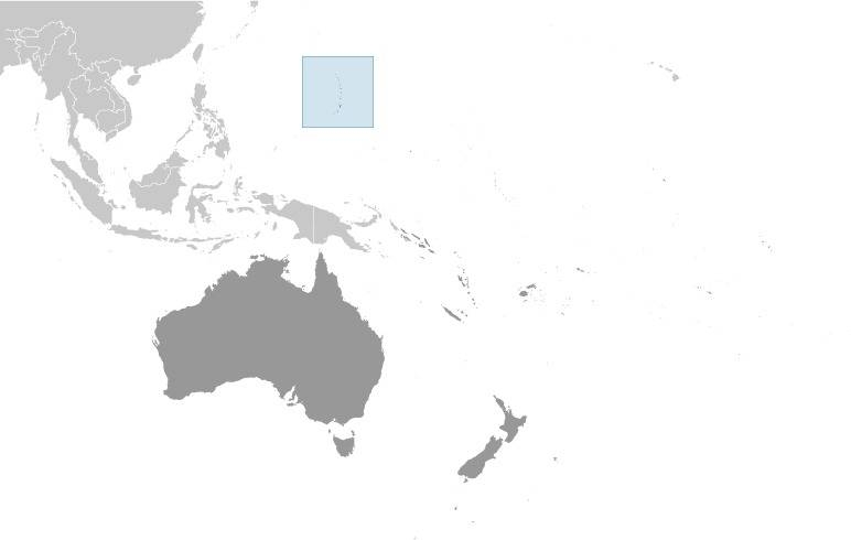
Source: CIA World Factbook
Map of the country:
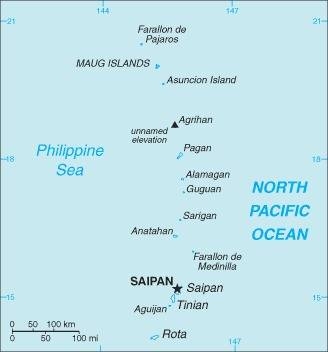
Source: CIA World Factbook
Area: The area of the Mariana Islands is given very different in the professional literature: 184 sq.mi., resp. 367 sq.mi., or even 396 sq.mi.
Inhabitants: 55.144 (2017), thereof 51% Asian (Filipino, Chinese, Korean, Japanese), 33% Polynesians and Micronesians (Chamorro, Carolinian, Palauan), 12% Multiracial, 2% Europeans
Religions: 81% Christian, 12% Buddhist, 5% Animist, 1% Non-Religious
Density of Population: 299 inh./sq.mi.
Capital: Garapan (on Saipan Island), 40.220 inh. (2010)
official Languages: English, Chamorro, Carolinian
other Languages: Chinese
Currency: 1 US-Dollar (USD, US$) = 100 Cents
Time Zone: GMT + 10 h
Source: 1.) Wikipedia (D), 2.) Wikipedia (EN)
ca. 1500 B.C. · first settlement on the islands
1521 · discovery of the Mariana Islands by the Portugese seafarer Fernão de Magalhães
1565 · the Spanish seafarer Urdaneta explores the Mariana Islands
1686 · the Mariana Islands become a Spanish possession, Spanish colonization
1898 · Spain sells Guam Island to the USA
1899 · Spain sells the remaining Mariana Islands to the German Empire
1914 · First World War (1914–1918), occupation by Japanese troops
1920 · Versailles Dictate, the German Empire loses all its colonies, the Mariana Islands become officially – together with the other German possessions (Marshall Islands and Caroline Islands) in Micronesia – as "Pacific Islands" a Mandate Territory of the League of Nations under Japanese mandate
1944 · Second World War (1939–1945), occupation by US-American troops
1945 · the Mariana Islands become officially hand over to the USA
1947 · formation of the UN trust territory of the "Pacific Islands" (Mariana Islands, Marshall Islands, Caroline Islands) under US-American administration
1965 · establishment of an own legislative congregation for the Pacific Islands
1978 · referendum for the formation of the Federated State of Micronesia after the end of the USA administration on the Pacific Islands, but the Mariana Islands leave the community of the Pacific Islands and become a with the USA associated state with the name Northern Mariana Islands
1986 · the Northern Mariana Islands reject in a plebiscite the independence and become even political connected to the USA. The residents of the islands are now citizens of the USA but have in US elections no suffrage.
1990 · official abolition of the UN trust territory
Source:
Atlas zur Geschichte,
World Statesmen,
Wikipedia (D)
Magalhães named the Mariana Islands initially "Ladrones" what means "thiefs". Toward the end of the 17th century the islands were renamed by Spanish Jesuits in "Mariana Islands" to honor of Maria Anna of Austria.
Source: Handbuch der geographischen Namen
