Nordwest-Territorien |
|
|
|
| Übersicht – Contents: | |
Nordwest-Territorien |
|
|
|
| Übersicht – Contents: | |
Flagge – Flag: |
|
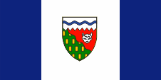 |
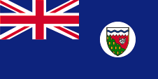
Flagge der Nordwest-Territorien – flag of the Northwest Territories, Seitenverhältnis – ratio = 1:2, Quelle/Source: Wikipedia (D)   |
historische Flaggen – historical Flags: |
|
 |
1682–1707,
|
 |
1707–1801,
|
 |
1801–1965,
|
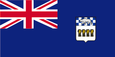 |
1950–1956, Flagge der Regierung (Staatsflagge) – flag of the government (state flag), Quelle/Source, nach/by: World Statesmen |
 |
1956–1969, Flagge der Regierung (Staatsflagge) – flag of the government (state flag), Quelle/Source, nach/by: World Statesmen, Wikipedia (D) |
Bedeutung/Ursprung der Flagge – Meaning/Origin of the Flag: |
|
| Die Flagge der Nordwest-Territorien wurde am 01.01.1969 erstmals gehisst. Sie zeigt drei vertikale Streifen in Blau, Weiß und Blau, und errinnert in ihrem Aufbau – mit dem breiten weißen Mittelstreifen, dem in der Mitte stehenden Wappen und den gleichfarbigen Streifen links und rechts – an die Flagge Kanadas. Das Blau steht für das Wasser und die Seen, das Weiß für das Eis und den Schnee. Die Flagge ging aus einem gesamt-kanadischen Wettbewerb als Sieger hervor. Der Entwurf stammte von Robert Bessant of Margaret aus Manitoba. | The flag of the Northwest Territories was hoisted for the first time on 1st of January in 1969. It shows three vertical stripes in blue, white and blue and remembers in its structure – with the wide white middle stripe, with the in the centre positioned coat of arms and the same coloured stripes to the left and on the right – the flag of Canada. The blue stands for the water and the seas, the white stands for the ice and the snow. The flag was the winner in a whole Canadian competition. The design was made by Robert Bessant of Margaret from Manitoba. |
| Zwischen 1869 und 1922 hätte von den Dienststellen der Territorien offiziell der britische Union Jack, die sogenannte Royal Union Flag, verwendet werden müssen, oder aber (ab 1922 im Prinzip nur noch) die kanadische blaue Dienstflagge, der typische Britische Blue Ensign, mit dem Wappenschild Kanadas im wehenden Ende. | Between the years 1869 and 1922 there had officially been used, the British Union Jack, the so-called Royal Union Flag, by the departments of the territories, or (from 1922 nearly only) the Canadian blue official flag, the typical British Blue Ensign, with the coat of arms of Canada in the flying end. |
| Wahrscheinlich hat man sich in den Nordwest-Territorien an die Regeln gehalten, zumal ein Territorium direkt der kanadischen Regierung untersteht. | It is believed that in the Northwest Territories the flag-rules were adhered to, especially because a territory is subordinated directly under the Canadian government. |
| Dennoch hatten die Behörden der Territorien eigene Siegel und später auch Wappen, die eigenmächtig im wehenden Ende auf der blauen Dienstflagge platziert wurden. Für dieses Verfahren hätte eine Genehmigung der britischen Behörden vorliegen müssen, was jedoch nicht der Fall war, aber toleriert wurde. | Nevertheless,
the authorities of the territories had their own seals and later also coats of arms,
which were unauthorized placed in the flying end of the blue official flag. A permit should have been approved by the British authorities for this procedure, this was not the case, but was tolerated. |
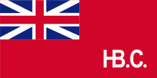
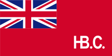
| So begann man um 1950 Blue Ensigns zu verwenden, die das Wappen des Territoriums im wehenden Ende zeigten. 1956 wurde ein neues Wappen eingeführt, was sich auch auf der Flagge bemerkbar machte. Zusätzlich wurde das Wappen inmitten einer weißen Scheibe im wehenden Ende der Flagge platziert. | Thus, they began to use Blue Ensigns from around 1950,
which showed the coat of arms of the territory in the flying end. In 1956, a new coat of arms was introduced, which also was to see on the flag. In addition, the coat of arms was placed in the middle of a white disc in the flying end of the flag. |
| Privatpersonen hatten den Union Jack zu verwenden und ab 1892 den sog. Red Ensign, die rote Version der kanadischen Flagge mit dem Union Jack in der Oberecke und dem Wappen Kanadas im wehenden Ende. | Private individuals had to use the Union Jack and from 1892 the so-called Red Ensign, the red version of the Canadian flag with the Union Jack in the upper corner and the coat of arms of Canada in the flying end. |
| Im Zuge der allmählichen Trennung Kanadas von Großbritannien verlor der Blue Ensign als amtliches, britisches Kennzeichen seine Bedeutung und man ersetzte ihn durch neue Provinzflaggen, die von Behörden und Dienststellen der Provinzen und auch von Privatpersonen verwendet werden dürfen. So führte die Nordwest-Territorien 1969 die heutige Flagge ein. | In
the course of the gradual separation of Canada from the United
Kingdom the Blue Ensign as an official British flag lost its
meaning and became replaced by new provincial flags, which may
be used by authorities and departments of the provinces and also
by private individuals. In this way, the Northwest Territories introduced the current flag in 1969. |
| Quelle/Source: Flaggen Enzyklopädie, World Statesmen, Wikipedia (D) | |
Wappen – Coat of Arms: |
|
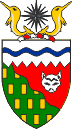 |
Wappen der Nordwest-Territorien – coat of arms of the Northwest Territories, Quelle/Source, nach/by: Wikipedia (D) |
Bedeutung/Ursprung des Wappens – Meaning/Origin of the Coat of Arms: |
|
| Das Wappen der Nordwest-Territorien wurde von Königin Elisabeth II. von Großbritannien am 07.02.1957 genehmigt. Das Schild ist in drei Felder geteilt. Das obere Feld ist weiß mit einer blauen Wellenline. Es steht für das Packeis und die Nordwest-Passage. Der restliche Teil des Schildes zeigt ein grünes und ein rotes Feld, durch eine Wellenlinie voneinander getrennt. Die Wellenlinie symbolisiert die Baumgrenze. Das Grün steht für die Wälder südlich der Baumgrenze, und das Rot steht für die Tundra des Nordens. Bodenschätze und Pelze sind die wichtigsten wirtschaftlichen Bereiche des Landes, repräsentiert durch Goldbarren im grünen Feld und den Kopf eines Polarfuchses im roten Feld. Oberhalb des Schildes ein rot-weißer Wulst, zwei goldene Narwale und eine Kompassrose. Letztere steht für den magnetischen Nordpol. | The coat
of arms of the Northwest Territories was approved by Queen Elizabeth II. of
United Kingdom on the 7th of February in 1957. The shield is divided in three fields. The upper field is white with a wavy blue line. It stands for the pack ice and the Northwest Passage. The remaining part of the shield shows a green and a red field, separated by a wavy line. The wavy line symbolizes the treeline. The green stands for the forests southern the treeline and the red stands for the tundra of the north. Minerals and fur are the most important economical areas of the country, represented by gold billets in the green field and the head of a arctic fox in the red field. Above the shield a red-white torus, two golden narwhals and a compass rose. The compass rose stands for the magnetic North Pole. |
| Quelle/Source, nach/by: Wikipedia (D) | |
Landkarte – Map: |
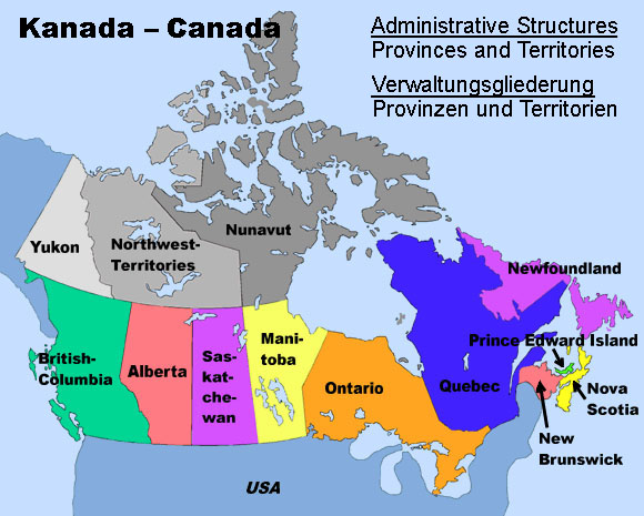 |
| Landkarte/Map: Volker Preuß |
Zahlen und Fakten – Numbers and Facts: |
|
|
|
|
|
|
|
|
|
|
|
|
|
|
|
|
|
|
Geschichte: |
| ca.
10.000–4.000 Jahre v.Chr. · Besiedlung durch Vorfahren der Eskimos ca. 1000 · Normannen erreichen die kanadische Ostküste 1576 · Martin Frobisher, ein englischer Seefahrer, entdeckt die Küste von Baffin Island 17. Jahrhundert · Expeditionen unter Henry Hudson, William Baffin und Robert Bylot 1670 · englische Pelzhändler gründen die Hudson's Bay Company (HBC), die HBC kolonisiert in der Folgezeit ganz Kanada zwischen Neufrankreich den Rocky Mountains, Labrador und dem Nordrand der Hudson-Bucht 1869 · die Hudson's Bay Company (HBC) überträgt alle ihre territorialen und Hoheitsrechte an das britische Dominion Kanada 1870 · Bildung der Nordwest-Territorien aus den Gebieten der HBC, Rupertsland und Nordwestliches Territorium, die Arktischen Inseln kommen unter direkte britische Verwaltung 1870 · Bildung der Provinz Manitoba durch Herauslösung aus den Nordwest-Territorien 1876 · Bildung des Keewatin-Territoriums durch Herauslösung aus den Nordwest-Territorien 1880 · Eingliederung der Arktischen Inseln in die Nordwest-Territorien 1881 · Vergrößerung der Provinz Manitoba durch Angliederung von Gebieten des Keewatin-Territoriums 1883 · Bildung der Territorien Alberta, Athabaska, Saskatchewan und Assiniboia durch Herauslösung aus den Nordwest-Territorien 1895 · Bildung des Franklin-Distrikts und des Mackenzie-Distrikts innerhalb der Nordwest-Territorien, und des Yukon-Territoriums im äußersten Nordwesten durch Herauslösung aus den Nordwest-Territorien 1905 · Eingliederung von Keewatin als Distrikt in die Nordwest-Territorien 1912 · nochmalige Vergrößerung der Provinz Manitoba durch Angliederung der südlichen Gebiete des Keewatin-Distrikts 1925 · Ausdehnung der Grenzen der Nordwest-Territorien als Sektorengrenzen bis hin zum Nordpol 01.04.1999 · Bildung des Eskimo Nunavut-Territoriums mit einer eigenen Regionalregierung durch Ausgliederung aus den Nordwest-Territorien auf Kosten des Keewatin-Distrikts, fast des gesamten Franklin-Distrikts und großer Teile des Mackenzie-Distrikts |
History: |
| ca.
10.000–4.000 years B.C. · settlement by ancestors of the Eskimos ca. 1000 A.D. · Normans reach the Canadian eastern coast 1576 · Martin Frobisher, an English seafarer, discovers the coast of Baffin Island 17th century · expeditions under Henry Hudson, William Baffin and Robert Bylot 1670 · English furriers establish the Hudson's Bay Company (HBC), the HBC colonizes in the afteryears whole Canada between New France, the Rocky Mountains, Labrador and the northern rand of the Hudson Bay 1869 · the Hudson's Bay Company (HBC) cedes all their territorial rights and prerogatives to the British Dominion of Canada 1870 · formation of the Northwest Territories from the former properties of the HBC, Rupertsland and Northwestern Territories, the Arctic Islands come under direct British administration 1870 · establishment of the Province of Manitoba by dividing off the Northwest Territories 1876 · establishment of the Keewatin Territory by dividing off the Northwest Territories 1880 · incorporation of the Arctic Islands into the Northwest Territories 1881 · enlargement of the Province of Manitoba by annexation of territories of the Keewatin Territory 1883 · establishment of the Territories Alberta, Athabaska, Saskatchewan and Assiniboia by dividing off the Northwest Territories 1895 · establishment of the District of Franklin and the District of Mackenzie within the Northwest Territories, establishment of the Yukon Territory in the outer northwest by dividing of the Northwest Territories 1905 · incorporation of Keewatin as district in the Northwest Territories 1912 · once again enlargement of the Province of Manitoba by annexation of the southern regions of the District of Keewatin 1925 · extension of the borders of the Northwest Territory as sector's frontiers towards the North Pole 1st of April 1999 · establishment of the Eskimo Nunavut Territory with an own regional government by dividing off the Northwest Territories at the cost of the District of Keewatin, of nearly the whole District of Franklin and of large parts of the District of Mackenzie |
| Quelle/Source: Atlas zur Geschichte, World Statesmen, Wikipedia (D), Discovery '97 |
Ursprung des Landesnamens – Origin of the Country's Name: |
|
| Die Nordwest-Territorien verdanken ihren Namen ihrer geographischen Lage. | The Northwest Territories owe their name to their geographical location. |
| Quelle/Source: Volker Preuß | |