mobile View, to the German Version tap the flag


- Canadian Territory
- own names:
– English: Northwest Territories
– French: Territoires du Nord-Ouest
• Flag
• Historical Flags
• Meaning/Origin of the Flag
• Coat of Arms
• Meaning/Origin of the Coat of Arms
• Map
• Numbers and Facts
• History
• Origin of the Country's Name
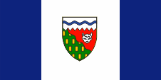
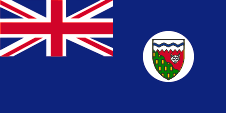
Flag of the Northwest Territories,
ratio = 1:2,
Source, by: Wikipedia (D)


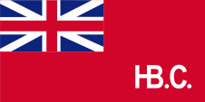
1682–1707,
Flag of the Hudson’s Bay Company,
ratio = 1:2,
Source, by:
Wikipedia (EN),
canadashistory.ca

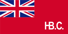
1707–1801,
Flag of the Hudson’s Bay Company,
ratio = 1:2,
Source, by:
Wikipedia (EN),
canadashistory.ca

1801–1965,
Flag of the Hudson’s Bay Company,
ratio = 1:2,
Source, by:
Wikipedia (EN),
canadashistory.ca
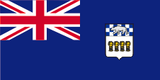
1950–1956,
Flag of the government (state flag),
ratio = 1:2,
Source, by:
World Statesmen
1956–1969,
Flag of the government (state flag),
ratio = 1:2,
Source, by:
World Statesmen, Wikipedia (D)
The flag of the Northwest Territories was hoisted for the first time on 1st of January in 1969. It shows three vertical stripes in blue, white and blue and remembers in its structure – with the wide white middle stripe, with the in the centre positioned coat of arms and the same coloured stripes to the left and on the right – the flag of Canada. The blue stands for the water and the seas, the white stands for the ice and the snow. The flag was the winner in a whole Canadian competition. The design was made by Robert Bessant of Margaret from Manitoba. Between the years 1869 and 1922 there had officially been used, the British Union Jack, the so-called Royal Union Flag, by the departments of the territories, or (from 1922 nearly only) the Canadian blue official flag, the typical British Blue Ensign, with the coat of arms of Canada in the flying end. It is believed that in the Northwest Territories the flag-rules were adhered to, especially because a territory is subordinated directly under the Canadian government. Nevertheless, the authorities of the territories had their own seals and later also coats of arms, which were unauthorized placed in the flying end of the blue official flag. A permit should have been approved by the British authorities for this procedure, this was not the case, but was tolerated. Thus, they began to use Blue Ensigns from around 1950, which showed the coat of arms of the territory in the flying end. In 1956, a new coat of arms was introduced, which also was to see on the flag. In addition, the coat of arms was placed in the middle of a white disc in the flying end of the flag. Private individuals had to use the Union Jack and from 1892 the so-called Red Ensign, the red version of the Canadian flag with the Union Jack in the upper corner and the coat of arms of Canada in the flying end. In the course of the gradual separation of Canada from the United Kingdom the Blue Ensign as an official British flag lost its meaning and became replaced by new provincial flags, which may be used by authorities and departments of the provinces and also by private individuals. In this way, the Northwest Territories introduced the current flag in 1969.
Source:
Flaggen Enzyklopädie,
World Statesmen,
Wikipedia (D)
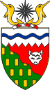
Coat of arms of the Northwest Territories,
Source, by:
Wikipedia (D)
The coat of arms of the Northwest Territories was approved by Queen Elizabeth II. of
United Kingdom on the 7th of February in 1957. The shield is divided in three fields. The upper field is white with a wavy blue line. It stands for the pack ice and the Northwest Passage. The remaining part of the shield shows a green and a red field, separated by a wavy line. The wavy line symbolizes the treeline. The green stands for the forests southern the treeline and the red stands for the tundra of the north. Minerals and fur are the most important economical areas of the country, represented by gold billets in the green field and the head of a arctic fox in the red field. Above the shield a red-white torus, two golden narwhals and a compass rose. The compass rose stands for the magnetic North Pole.
Source:
Wikipedia (D)
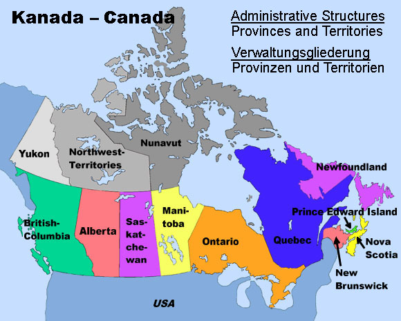
Map:
Volker Preuß
Area: 441.619 square miles
Inhabitants: 41.786 (2016), thereof 60% Anglo Canadians, 30% Eskimo (Inuit), 4% native Indians, 2% Franco Canadians
Density of Population: 0,09 inh./sq.mi.
Capital: Yellowknife, 19.569 inh. (2016)
official Languages: English, French, Native languages
Currency: Canadian currency
Time Zone: GMT – 7 h
Source:
Wikipedia (D)
ca. 10.000–4.000 years B.C. · settlement by ancestors of the Eskimos
ca. 1000 A.D. · Normans reach the Canadian eastern coast
1576 · Martin Frobisher, an English seafarer, discovers the coast of Baffin Island
17th century · expeditions under Henry Hudson, William Baffin and Robert Bylot
1670 · English furriers establish the Hudson's Bay Company (HBC), the HBC colonizes in the afteryears whole Canada between New France, the Rocky Mountains, Labrador and the northern rand of the Hudson Bay
1869 · the Hudson's Bay Company (HBC) cedes all their territorial rights and prerogatives to the British Dominion of Canada
1870 · formation of the Northwest Territories from the former properties of the HBC, Rupertsland and Northwestern Territories, the Arctic Islands come under direct British administration
1870 · establishment of the Province of Manitoba by dividing of the Northwest Territories
1876 · establishment of the Keewatin Territory by dividing off the Northwest Territories
1880 · incorporation of the Arctic Islands into the Northwest Territories
1881 · enlargement of the Province of Manitoba by annexation of territories of the Keewatin Territory
1883 · establishment of the Territories Alberta, Athabaska, Saskatchewan and Assiniboia by dividing off the Northwest Territories
1895 · establishment of the District of Franklin and the District of Mackenzie within the Northwest Territories, establishment of the Yukon Territory in the outer northwest by dividing off the Northwest Territories
1905 · incorporation of Keewatin as district in the Northwest Territories
1912 · once again enlargement of the Province of Manitoba by annexation of the southern regions of the District of Keewatin
1925 · extension of the borders of the Northwest Territory as sector's frontiers towards the North Pole
1st of April 1999 · establishment of the Eskimo Nunavut Territory with an own regional government by dividing off the Northwest Territories at the cost of the District of Keewatin, of nearly the whole District of Franklin and of large parts of the District of Mackenzie
Source:
Atlas zur Geschichte,
World Statesmen,
Wikipedia (D),
Discovery '97
The Northwest Territories owe their name to their geographical location.
Source:
Volker Preuß
