mobile View, to the German Version tap the flag


- former Boer republic
- own names:
– Afrikaans: Nieuwe Republiek
– English: New Republic
• Flag
• Meaning/Origin of the Flag
• Map
• Numbers and Facts
• History
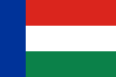
1884–1888,
National flag,
ratio = 2:3,
Source, by: World Statesmen


The flag of the New Republic showed three horizontal stripes in red, white and green and a vertical blue bar at the leech. The model for the designing of the flag could have been the flag of Transvaal, but in an other sequenze of colours.
Source: Volker Preuß
Interactive Map of the Boer's Republics and of the Cape Colony,
today's borders in red:
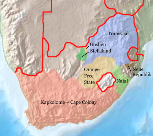
Source: Freeware, University of Texas Libraries, modyfied by: Volker Preuß
Area: ca. 5.300 square miles
Inhabitants: unknown
Capital: Vrijheid
Source:
Wikipedia (EN)
1602 · the Netherlanders appropriate the land around the Cape of Good Hope (Kapland), settlement of Boers (farmer of Dutch and German descent, self-designation: Afrikaander)
1652 · Jan van Riebeeck founds the smallholding Kapstadt in mission of the Dutch East Indian Company
1806 · United Kingdom occupys Kapland
1814 · United Kingdom annexes Kapland officially, establishment of the British Cape Colony
1833 · abolition of slavery
1836–1885 · the Boers leave Kapland in long treks towards east and northeast and establish various Boer republics
1884 · establishment of the New Republic by Boers
1886 · United Kingdom recognizes the New Republic
1888 · incorporation into the South African Republic (Transvaal)
1899–1902 · Boers War, United Kingdom submits the Boer's States of Orange Free State and Transvaal, both become British colonies, chase and internment of the Boers, establishment of concentration camps for the Boers
1903 · to the British Natal Colony
Source:
Atlas zur Geschichte,
World Statesmen,
Wikipedia (EN)
