mobile View, to the German Version tap the flag


- Principality of Lichtenberg
- 1819–1834
• Flag
• Meaning/Origin of the Flag
• Coat of Arms
• Meaning/Origin of the Coat of Arms
• Map
• Numbers and Facts
• History
• Origin of the Country's Name

1816–1834,
Colours of the country,
Source, by: World Statesmen


The colours of the country are the colours of the Duchy of Saxe-Coburg. The former Albertine electorate and new kingdom of Saxony joined the Rhine Confederation on 11th of December in 1806, on 15th of December in 1806 followed by the Ernestine duchies in Thuringia. The troops of the duchies were consolidated and equipped with cockades in the national colors black and gold in accordance with the convention of the 13th of February in 1807. The cockades of the Kingdom of Saxony remained white. When the Kingdom of Saxony changed its national colors to white and green on 16th of June in 1815, the Saxon duchies in Thuringia, governed by the Ernestine Wettin family, mostly followed this rule for their national colors, flags and cockades. The arrangement of white and green was varied in different ways. Unfortunately, it is not known whether, when and how this was implemented for Saxony-Coburg-Saalfeld. In the period from ca. 1815 to ca. 1830, this process was finally completed.
Source:
Volker Preuß, Jens Hild
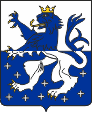
Coat of arms of Lichtenberg,
Source, by: www.patrick-alles.de
The coat of arms of the principality shows a between white and blue splited shield (the blue field is spangled with white crosses), on it a golden armored, crowned lion with interchanged colors. It reminds the coats of arms of the Counts of Veldenz, which showed a blue lion on white. The Counts of Veldenz were landowners in the region from 13th to 15th century, and they owned the Castle of Lichtenberg too.
Source: Volker Preuß
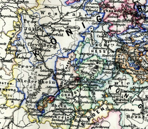
Map/Source: Hand-Atlas für die Geschichte des Mittelalters und die neueren Zeit, 1880, modyfied by: Volker Preuß
The map shows the Principality of Lichtenberg in the southwest, within an orange coloured border.
Area: 207 square miles
Inhabitants: 25.000 (1816)
Density of Population: 121 inh./sq.mi. (1816)
Capital: St. Wendel
Currency: 1 Gulden = 60 Kreuzer = 240 Pfennige
Source:
Historisches Deutschland,
Wikipedia (D)
1814–1815 · Vienna Congress, reorganization of Europe after the Napoleonic era, establishment of the German Confederation
1816 · Duke Ernst I. of Saxony-Coburg-Saalfeld receives for his services as a military leader in the fight against Napoleon a territory, the "Dominion of Baumholder," which before Napoleon most belonged to the Bavarian Palatinate, the Electorate of Trier, the County of Leyen or the Rhine County
1819 · Duke Ernst I. renames the Dominion of Baumholder in "Principality of Lichtenberg"
May 1834 · political riots, the Duke solds the counrty to Prussia, which affiliates it as "District of St. Wendel" to the administrative district of Trier in the Rhine Province
Source: Wikipedia (D)
The principality was named after the between the cities Baumholder and Kusel placed Castle of Lichtenberg.
Source: Wikipedia (D)
