mobile View, to the German Version tap the flag


- Republic of Namibia (South West Africa)
- presidial republic
- own names
– Afrikaans: Republiek van Namibia
– English: Republic of Namibia
– German: Republik Namibia
• Flags
• Historical Flags
• Meaning/Origin of the Flag
• Coat of Arms
• Meaning/Origin of the Coat of Arms
• Aircraft Roundel
• Map
• Numbers and Facts
• History
• Origin of the Country's Name
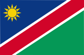
National flag,
ratio = 2:3,
Source, by: Corel Draw 4


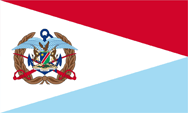
Flag of the Armed Forces,
ratio = 3:5,
Source, by: Skjoldbro, Public domain, via Wikimedia Commons

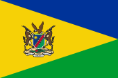
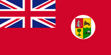
Flag of the President,
ratio = 2:3,
Source, by: Wikipedia (D)

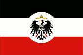
1893–1919,
German Empire,
official flag of colonial office / foreign office,
ratio = 2:3,
Source, by: Flags of the World
1914,
planned flag for German South West Africa,
ratio = 3:5,
Source, by: Flags of the World,
Flag Reconstruction following Mark Sensen (Feb 98)
based on traditional interpretation from Afrika-Nachrichten article 1933


1915–1919,
Flag of United Kingdom,
ratio = 1:2,
Source, by: World Statesmen
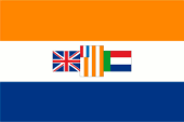
1919–1928,
National and merchant flag of South Africa,
ratio = 1:2,
Source, by: World Statesmen
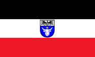
1928–1982,
National flag of South Africa,
ratio = 2:3,
Source, by: World Statesmen
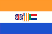
1982–1990,
National flag of South Africa,
ratio = 2:3,
Source, by: World Statesmen

1966–1990,
recognized by the UN,
Flag of the SWAPO as national flag,
ratio = 2:3,
Source, by: World Statesmen
The today's flag was hoisted for the first time on 21st of March in 1990 in occasion of the proclamation of independence. It ist diagonally divided by a white bordered red stripe. Left above a blue triangle with a twelve-pointed yellow sun, right below a green triangle. Officially stands blue for the heaven, the Atlantic, rain and water, the yellow sun for live-power. Red stands for the nation, white for the peaceful cohabit of the various residental groups, as well as for unity and peace. Green is the symbol for vegetation and fruitfulness. The flag is actually based on the colours of the flag of the SWAPO (blue, red and green horizontally striped), that political movement which lead Namibia into the independence. The slender white stripes and the golden sun have been added only because to reperesent the colours of other parties. The twelve points of the sun could also represent the twelve ethnical groups of the country. The colours of the flag are laid down in the "Government Gazette". They are given as follows: Blue = Pantone 294, Yellow = Pantone 116, Green = Pantone 347, Red = Pantone 186. The presidential flag and the flag of the Armed Forces are based on the presidential flag used in South Africa until 1994. As a German colony, the country did not use an own or special flag. There were used the colors of the German Empire: black, white and red. Authorities used the flag of the Colonial Office as well as varieties of it. That was black, white and red horizontally striped and showed in the middle of it a white disc with the imperial eagle. From 1913 it was considered to create own emblems for the colonies. First drafts were made in 1914, but the project was not realized because of the outbreak of the First World War and because of the loss of the colonies.
Source:
Flaggen und Coat of arms of the Welt,
Die Welt der Flaggen,
Wikipedia (D),
Flags of the World
since 1990,
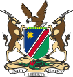
Coat of arms of Namibia,
Source: Corel Draw 4
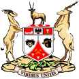
1963–1980,
Coat of arms of South West Africa,
Source: Samhanin, CC BY 3.0, via Wikimedia Commons
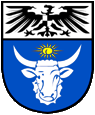
1914,
planned coat of arms of German South West Africa,
Source: Flags of the World,
Flag Reconstruction following Mark Sensen (Feb 98)
based on traditional interpretation from Afrika-Nachrichten article 1933
The today's coat of arms was introduced on 21st of March in 1990. It shows in the shield the design of the flag. Shield-supporters are two Oryx-Antelopes. Above the shield are to see six stylized diamonds in a green torus, there above an fish-eagle. Below the shield a green Welvitschia-Mirabilis plant with three red blossoms. Down below a white banner with the motto of the state: "Unity, Liberty, Justice". In the times as Namibia belonged as South West Africa to South Africa was in use a similar coat of arms. It showed a white main-shield with a from below inwards bended red point. The red point was added by symbols of mining: hammer and pickhammer crossed and in gold as well as three stylized diamonds. The point was escorted to the left and to the right by an aries-head and an ox-head. The top of the shield was threefold partitioned. The first field was red and showed the silvery silhouette of a fortifyed housing estate, the second field was white with the Eagle of the German Empire (the former colonial might) in the middle, and the third field was red and showed a crucifix upon a green hill. Above the shield was a red-white torus with a Oryx antelope on it. Shield-supporters are two antelopes of other species. The shield pedestal was the same like in the today's coat of arms, but the Welvitschia plant was not flourishing. The banner showed the Latin motto "Viribus Unitis" → "With united Forces". The country was once a German colony. The German colonies – except Kiaochow – had been subordinated under the Imperial Colonial Office. Accordingly, public authorities used its seals, flags, and the Imperial coat of arms. From 1913 it was considered to create own emblems for the colonies. First drafts were made in 1914, but the project was not realized because of the outbreak of the First World War and because of the loss of the colonies. The imaginary appearance of the coats of arms and flags could only be reconstructed on the basis of fragments in the 20s and 30s of the 20th century. Most of the reconstructions refer to an article in the newspaper "Afrika-Nachrichten" from 1933 and the subsequent reconstructions of the Dutch vexillologist Mark Sensen from February 1998, which are also taken into account on these pages. The coats of arms themselves should additionally show the imperial crown above the escutcheon, but not on the flags, following the reconstruction of Mark Sensen. The escutcheons always showed the same structure: A horizontally twofold splited shield, the head of the shield showed the imperial eagle on white ground with the escutcheon of the House of Hohenzollern on the chest. In the main part appeared a stylized representation of plants, animals or landscapes, which were colored differently depending on the country. The planned coat of arms of South West Africa showed a white ox's head under a diamond on a blue background.
Source:
Flaggen und Coat of arms of the Welt,
Die Welt der Flaggen,
Wikipedia (D),
Flags of the World

Aircraft Roundel,
Source, by: Wikipedia (DE)
Location:
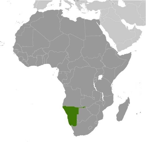
Source: CIA World Factbook
Map of the country:
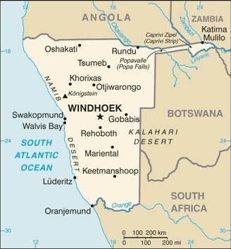
Source: CIA World Factbook
Area: 318.191 square miles
Inhabitants: 2.324.388 (2016), thereof 82% Bantu, 7% Europeans (of which 22.000 Deutsche), 8% Mulattos, 3% Bushmen (San)
Religions: 44% Protestant, 23% Roman Catholic, 17% Anglican, 4% other Christian, 10% Animist, 1% Non-Religious
Density of Population: 7,3 inh./sq.mi.
Capital: Windhuk (Windhoek), 461.000 inh. (2022)
official Languages: English and various national languages like Afrikaans, Bantu languages, German
Currency: 1 Namibia-Dollar (NAD, N$) = 100 Cents
Time Zone: GMT + 2 h
Source:
Wikipedia (D),
Wikipedia (EN)
Middle Ages · South West Africa is populated by Bushmen (San), Ovambo and Damara
1485 · the Portugese seafarer Diego Cão discoveres and explores the coast of South West Africa
17th cent. · immigrating Nama tribes – like the Hottentotts (Khoi-Khoin) – push aside the pristine population into the deserts
18th cent. · Herero and Ovambo (Bantu nations) invade South West Africa and settle
19th cent. · from the south immigrate europeized Khoi-Khoin tribes (Orlam)
1842 · the German Rhenish Mission Society starts its work
1851 · the Orlam and Nama vanquish the Herero
1863–1870 · once more war of the Orlam and Nama against the Herero
1878 · United Kingdom occupies the Whalefish Bay and subordinates it to the Cape Colony
1883 · the company F.A.E. Luederitz establishes in the Angra Pequena Bay (today Luederitz Bay) in the housing estate Luederitz
1884 · foundation of the town Bethanien
24th of April 1884 · the German Empire subordinates the possessions of the company F.A.E. Luederitz (coastal area of South West Africa) unser its protection
1885 · foundation of the German Colonial Society for South West Africa, expansion of the German colonial possession to 92 700 sq.mi., first immigration of German settlers, border treaty with United Kingdom about the course of the border in the south and in the east
1886 · border treaty with Portugal about the course of the border in the north (Angola)
1890 · border treaty with United Kingdom about the course of the border in the north east (Caprivi Strook)
1894 · the last resistance of the Nama under Hendrik Witbooi is broken
1904 · Herero revolt in the central north, short-termly suppressed
1904 · Nama revolt under Hendrik Witbooi in the central south, suppressed not until 1907, further immigration of German settlers
1908 · discovery of the diamond fields in the Namib Desert
1914–1918 · First World War (1915/16 · occupation of South West Africa by British and South African troops)
1920 · Versailles Dictate, the German Empire loses all its colonies, South West Africa becomes a Mandate Territory of the League of Nations under South African mandate, the German settlers get not exiled (in difference to the other German colonies), South Africa supports the settlement of South West Africa by Boers
1945 · South Africa recognizes the UNO not as succeeding organization of the League of Nations, because for South West Africa is planned as final target of the trust administration (of the UNO) the independence of the country
1946 · a referendum (under the Europeans and Boers) decides for the directly annexion to the South African Union
1948 · introduction of the apartheid
1949 · South West Africa (incl. the Whalefish Bay) gets annexed by the South African Union as its fifth province
1959 · foundation of the SWANU-Party (South West African National Union), supported by the Herero, Nama and Damara
1960 · foundation of the SWAPO-Party (South West African People's Organization), supported by the Ovambo
1964 · establishment of homelands for the Africans
1966 · official abolition of the South African UNO Mandate for South West Africa, the SWAPO starts the armed struggle for independence
1967 · the UNO destines an international administration council for South West Africa
1968 · the UNO renames South West Africa in Namibia
1976 · South Africa plans to dismiss Namibia into the independence in the year 1978, this project fails because the UNO wants to deploy troops in the region
1977 · South Africa deploys for Namibia a General Administrator, the country is in this way no longer a province of South Africa, South Africa annexes the Whalefish Bay
1978 · elections without participation of the SWAPO, not recognized by the UNO
1985 · establishment of a Black-African transient government for Namibia, but without participation of the SWAPO
1988 · agreement between South Africa, Angola and Cuba for free elections in Namibia and the withdrawal of the Cuban troops from Angola
1989 · elections under participation of the SWAPO, the SWAPO wins the majority in the parliament
21st of March in 1990 · independence, proclamation of the Republic of Namibia, new constitution, Namibia becomes member of the Commonwealth of Nations and the UNO
1994 · South Africa cedes the Whalefish Bay back to Namibia
1994 · once more victory of the SWAPO in elections
1997 · protest of the Bushmen (San) for the preservation of their property rights become suppressed by force
1999 · once more victory of the SWAPO in elections
2005 · some of the European settlers have to sell their land under prize to Namibia (de facto expropriation)
Source:
Atlas zur Geschichte,
World Statesmen,
Discovery '97,
www.merkur.de
The real name of the country is South West Africa, but the UNO decided in the year 1968 to rename the land in Namibia. The word "Namibia" has its roots in the name of the "Namib" Desert which expands in a width of 20 to 40 miles along nearly the whole coast of the Atlantic Ocean. The name of the "Namib" Desert goes back to the Nama tribes (Hottentotts) which immigrate in here the 17th century.
Source: Handbuch der geographischen Namen, Volker Preuß
