Source, by: Flags of the World


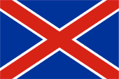
1874–1875,
National flag,
ratio = 2:3,
Source, by: Flags of the World


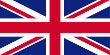
1877–1884, 1902–1910,
Union Flag → quasi National flag,
Flag of United Kingdom,
ratio = 1:2,
Source, by: Flags of the World


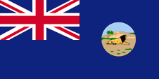
1902–1910,
theoretical, probably never used,
Flag of the government (state flag),
ratio = 1:2,
Source, by: Flags of the World


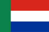
The flag of Transvaal featured three horizontal stripes of red, white and blue and a vertical green bar on the leech, close to the mast. The design of the flag was based on the flag of the Netherlands (also called "Prinsenvlag"), which in South Africa is called the Van Riebeeck flag because it was used by the early Dutch settlers. A differently designed flag was briefly used between 1874 and 1875. It showed a red diagonal cross with narrow white dividing lines on a solid blue background.
After Britain's fierce war of conquest, a British colonial administration was set up that used its own badge, which showed a landscape with a down lying lion. This was common in all British colonies, its own symbolism or heraldry, because documents had to be sealed, etc. Such a badge was often a regional landscape representation placed on a disk, often showing ships, historical events or even a kind of a logo. Very often, a badge also showed the name of the country or a motto. Some British possessions, however, already had a coat of arms from the beginning, or their badge was replaced by a coat of arms over the years. To ensure a uniform appearance in the flying end of the flags, coats of arms and other symbols were displayed on a white disk in the size of the earlier badges. There were also exceptions, because some colonies did not use the white disk and placed their escutcheon or even coat of arms directly on the bunting, sometimes enlarged.
In 1904, after the British conquest, the Union Flag was raised. The country had become part of the British Empire. From 1902 onwards, the British administration could have used a "Blue Ensign", a dark blue flag bunting with a representation of a flag – the British Union Jack – in the upper corner and the administration's badge in the waving end. However, the Admiralty did not give permission for this. Firstly, the Blue Ensigns were actually intended for use at sea, the Orange Free State was a landlocked state, even if these flags were often used on land, Secondly, after the bitter resistance of the Boers, the symbols of the new power would have been used quite hesitantly in order not to provoke new uprisings, as had happened so often before. If the Blue Ensign ever actually existed, it was used without authorization, which however happened quite often in other colonies. The Orange Free State will have been excluded from the Ensign system.
United Kingdom introduced a flag system in 1864 in which:
• war ships fly the "White Ensign" (naval flag), a white flag often with an uninterrupted red St. George's-Cross and with the Union Jack in the upper staff quadrant of the flag,
• merchant ships fly a "Red Ensign" (also named "Civil Ensign" → civil flag, the real merchant flag), a red flag with the Union Jack in the upper staff quadrant of the flag, and
• governmental ships fly the "Blue Ensign" (flag for the use by the gouvernment → the actual state flag), a blue flag with the Union Jack in the upper staff quadrant of the flag.
Since 1865 ships of colonial governments were permitted to fly the Blue Ensign with a badge in the flying end of the flag. The respective governments were asked to design appropriate badges. Merchant ships and seafaring persons from colonies were only permitted to use the Red Ensign with a badge, then also named Civil Ensign, if permission has been given to the respective colony by the British admiralty.
As a province of South Africa, the country still did not have its own flag.
Source:
Flags of the World,
Die Welt der Flaggen,
Flaggen Enzyklopädie,
World Statesmen,
Wikipedia (EN)

Map of the Boer's Republics and of the Cape Colony,
today's borders in red:
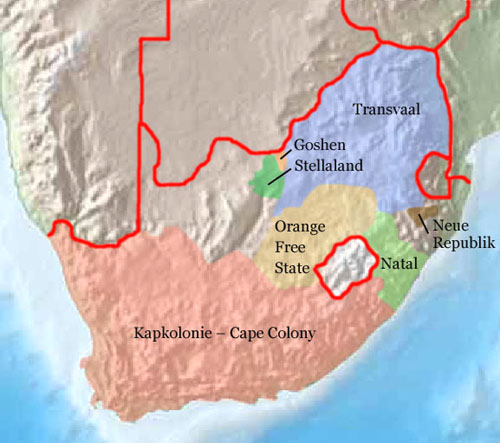
Source: Freeware, University of Texas Libraries, modyfied by: Volker Preuß

Area: ca. 111.196 square miles
Inhabitants: 490.000 (1886), 9.491.265 (1991)
Capital: Pretoria (since 1880, previously in Heidelberg), 739.043 inh. (1980)
Languages: Afrikaans, English, Bantu Languages
Time Zone: GMT + 2 h
Source:
Wikipedia (EN),
Länder der Erde,
World Statesmen,
Meyers Konversationslexikon

1602 · the Netherlanders appropriate the land around the Cape of Good Hope (Kapland), settlement of Boers (farmer of Dutch and German descent, self-designation: Afrikaander)
1652 · Jan van Riebeeck founds the smallholding Kapstadt in mission of the Dutch East Indian Company
1806 · United Kingdom occupys Kapland
1814 · United Kingdom annexes Kapland officially, establishment of the British Cape Colony
1833 · abolition of slavery
1836–1885 · the Boers leave Kapland in long treks towards east and northeast and establish various Boer's republics
1845 · the British conquer Natal
1853 · establishment of the South African Republic (the later Transvaal)
1877 · the British submit the South African Republic and establish the Transvaal Colony
1881 · anti-british revolt of the Boers in Transvaal, United Kingdom grants autonomy as Transvaal State
1884 · re-establishment of the South African Republic in Transvaal
1899–1902 · Boers War, United Kingdom submit the Boer's States of Orange Free State and Transvaal, both become British colonies, chase and internment of the Boers, establishment of concentration camps for the Boers
1906 · United Kingdom grants autonomy
1910 · United Kingdom joins the colonies Orange Free State, Transvaal, Natal and Cape Province to the South African Union, status of a British dominion for South Africa
27.04.1994 · new constitution for South Africa, official abolition of the racial segregation, dissolution of the homelands, membership in the Commonwealth of Nations again, division of Transvaal
Source:
Wikipedia (EN),
World Statesmen,
Meyers Konversationslexikon,
Discovery '97

The Boer's named their republic initially "South African Republic". The name "Transvaal" was introduced by the British. That name expresses the position of the country "beyond of Vaal", a big river in the central South Africa.
Source: www.britannica.com


![]()



![]()
