mobile View, to the German Version tap the flag


- Federal Republic of Nigeria
- presidial republic under military rule
- own name: Federal Republic of Nigeria
- Parts of the country were formerly known as or known for: Lagos Colony, Niger Coast Protectorate, Oil Rivers Protectorate, Northern Nigeria, Southern Nigeria, Royal Niger Company
• Flags
• Historical Flags
• Meaning/Origin of the Flag
• Coat of Arms
• Meaning/Origin of the Coat of Arms
• Aircraft Roundel
• Regional Flags:
Secessionist state of Biafra
• Map
• Numbers and Facts
• History
• Origin of the Country's Name
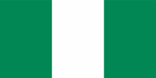
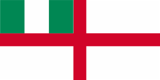
National flag and naval jack,
ratio = 1:2,
Source, by: Flags of the World


Merchant flag,
ratio = 1:2,
Source, by: Flags of the World

State flag,
ratio = 1:2,
Source, by: Flags of the World

offshore state flag,
ratio = 1:2,
Source, by: Flags of the World

since 1998,
Naval flag,
ratio = 1:2,
Source, by: commons.wikimedia.org,
Flags of the World
Flag of the President,
ratio = 3:5,
Source, by: Flags of the World

1870–1888,
British West African Settlements,
Flag of the government (state flag),
ratio = 1:2,
Source, by: Wikipedia (EN)
1879–1900,
Royal Niger Company,
Flagge der R.N.C.,
ratio = 1:2,
Source, by: Flags of the World
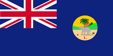
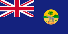
1888–1906,
Lagos Colony,
Flag of the government (state flag),
ratio = 1:2,
Source, by: Flags of the World
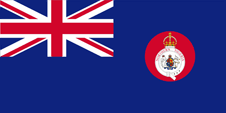
1885–1893,
Oil Rivers Protectorate,
Flag of the government (state flag),
ratio = 1:2,
Source, by: Flags of the World
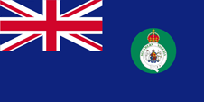
1893–1900,
Niger Coast Protectorate,
Flag of the government (state flag),
ratio = 1:2,
Source, by: Flags of the World
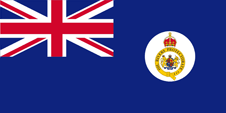
1900–1914,
Southern Nigeria,
Flag of the government (state flag),
ratio = 1:2,
Source, by: Flags of the World
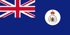
1900–1914,
Northern Nigeria,
Flag of the government (state flag),
ratio = 1:2,
Source, by: Flags of the World
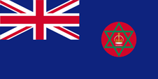
1914–1952,
Nigeria,
Flag of the government (state flag),
ratio = 1:2,
Source, by: Flags of the World

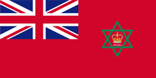
1914–1952,
Nigeria,
Merchant flag,
ratio = 1:2,
Source, by: Flags of the World

1952–1960,
Nigeria,
Flag of the government (state flag),
ratio = 1:2,
Source, by: Flags of the World
1952–1960,
Nigeria,
Merchant flag,
ratio = 1:2,
Source, by: Flags of the World
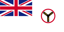
ca. 1963,
Flag of the President,
ratio = 1:2,
Source, by: Flags of the World
1960–1998,
Naval flag,
ratio = 1:2,
Source, by: Flags of the World
The today's flag of Nigeria was officially hoisted on 1st of October in 1960, by another source already on 16th of December in 1959. It is a result of an in 1959 performed competition. The design was made by a student for engineering. He saw in front of the eyes the green land which is divided by the shiny Niger River, an idea which is returning in the coat of arms, too. The flag shows because of that three vertical stripes in green, white and green. Green stands for the woods and the agriculture which remains the backbone of the national economy despite the mineral-oil-richness and beginning industrialization while white should symbolize the unity and peacefulness of the people of Nigeria. Most of the country's other flags, which are not a national flag, indicate in their design the former connections with United Kingdom, because the country is oriented towards the British Ensign system until today. The colour green in the the flag seems today to be defined as follows: HEX #003594, which would correspond to Pantone 348.
In the mid-19th century, the United Kingdom began to acquire colonies and to establish protectorates on the coast of the Gulf of Guinea. Australia, India, Canada and South Africa were already British colonies, and more colonies were acquired around the world. The British Union Jack flew all over the world. The idea was soon born to create a system for the use of flags that would allow conclusions to be drawn about the owner, the purpose or even the region of the British Empire based on the appearance of the flag. United Kingdom introduced a flag system in 1864 in which:
• war ships fly the "White Ensign" (naval flag), a white flag often with an uninterrupted red St. George's-Cross and with the Union Jack in the upper staff quadrant of the flag,
• merchant ships fly a "Red Ensign" (also named "Civil Ensign" → civil flag, the real merchant flag), a red flag with the Union Jack in the upper staff quadrant of the flag, and
• governmental ships fly the "Blue Ensign" (flag for the use by the gouvernment → the actual state flag), a blue flag with the Union Jack in the upper staff quadrant of the flag.
Since 1865 ships of colonial governments were permitted to fly the Blue Ensign with a badge in the flying end of the flag. The respective governments were asked to design appropriate badges. Merchant ships and seafaring persons from colonies were only permitted to use the Red Ensign with a badge, then also named Civil Ensign, if permission has been given to the respective colony by the British admiralty. On land, the British Union Jack continued to be used by private individuals and also by offices and authorities. At least, that is how it was prescribed. In many British colonies, however, despite the prohibition from London, offices and authorities also used the Blue Ensign of the governmental ships on land, or citizens used the Red Ensign not only as a merchant flag, but also on land. Red Ensigns were often created for this purpose without permission from London, and of course with the bagde in the flying end. Such a badge was often a regional landscape representation placed on a disk, often showing ships, historical events or even a kind of a logo. Very often, a badge also showed the name of the country or a motto. Some British possessions, however, already had a coat of arms from the beginning, or their badge was replaced by a coat of arms over the years. To ensure a uniform appearance in the flying end of the flags, coats of arms and other symbols were frequently displayed on a white disk in the size of the earlier badges. There were also exceptions, because some colonies did not use the disk and placed their escutcheon or even coat of arms directly on the bunting, sometimes enlarged. Already in the '40s they started to remove the disk and placed the coat of arms directly or enlarged. This conversion process was done gradually, nowhere at the same time and completely. In some British possessions, flags with the disc are still in use, in others no more and in some areas are both variants in use, next to each other.
When Lagos became a separate colony again in the year 1888, they hoisted here as national flag the British official flag (Blue Ensign) with an emblem in the flying end. That showed exactly like in other British West African colonies (Gambia, Gold Coast, Sierra Leone) a disk with a scenic depiction and an elephant beside a palm tree in the foreground. That badges had been differentiated by red letters below the elephant. The Colony of Lagos used an "L.". The other British possessions and protectorates in the east of Lagos were summarized in the year 1885 in the Oil Rivers Protectorate. Here they also hoisted as national flag the British official flag (Blue Ensign) with an emblem in the flying end. That was a white disk with the by a golden belt surrounded British coat of arms in the middle. Above the belt the British crown and on the belt the name of the protectorate. In the year 1893 the Oil Rivers Protectorate was transformed in the Niger Coast Protectorate. According to this fact was also changed the badge in the flag. The belt became silvery and the name of the protectorate became updated. In 1900 the Niger Coast Protectorate was transformed in the Protectorate of South Nigeria and the possessions of the Royal Niger Co. around Lokoja had been summarized in the new created Protectorate of North Nigeria. In both protectorates were hoisted as national flags the British official flag (Blue Ensign) again with an emblem on a disk in the flying end. That disk was in North Nigeria red and in South Nigeria green. On it the British coat of arms surrounded by a silvery belt with the respective name of the protectorate. Above the belt the British crown. North and South Nigeria had been unifyed in the year 1914. Colony and Protectorate of Nigeria – how the territory now was named – used as national flag the British official flag (Blue Ensign) again with an emblem on a red disk in the flying end. On it a six-pointed green Seal of Salomo. In its middle the British crown and underneath the written character "NIGERIA".
Source:
Flaggen Wappen Hymnen,
Die Welt der Flaggen,
Flags of the World,
Wikipedia (DE),
Wikipedia (EN),
Volker Preuß
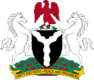
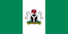
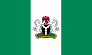
Coat of arms of Nigeria,
Source: Corel Draw 4
The coat of arms of Nigeria was awarded by queen Elisabeth II. on 28th of April in 1960. It shows a black shield (symbol for the fruitful soil of the land, respectively an allusion to the word "Nigeria"), on it a silvery wave-fork which depicts the merger of the rivers Niger and Benue. The red eagle on the white-green torus is an allegory for the strength, the horses are signs of dignity.
Source:
Flaggen Wappen Hymnen

Aircraft Roundel,
Source, by: Wikipedia (EN)

Aircraft Roundel for Naval Aviation,
Source, by: Wikipedia (EN)
Location:
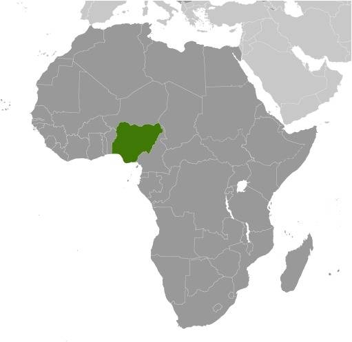
Source: CIA World Factbook
Map of the country:
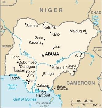
Source: CIA World Factbook
Area: 356.667 square miles
Inhabitants: 219.500.000 (2021), thereof 29% Hausa and Fulbe, 21% Yoruba, 18% Igbo, 10% Ijaw, 4% Kanuri, 4% Ibibio, 2% Tiv
Religions: 51% Muslim, 47% Christian
Density of Population: 615 inh./sq.mi.
Capital: Abuja, 2.750.000 inh. (2017), capital to 1992: Lagos, 14.370.000 inh. (2020)
official Language: English
national Languages: Hausa, Igbo, Yoruba
other Languages: 525 other Sudanese and Bantu languages
Currency: 1 Naira (NGN, N) = 100 Kobo
Time Zone: GMT + 1 h
Source: Wikipedia (D)
antiquity · states of the Nok Tribes
10th/11th century · parts of the territory in the northeast of the today's Nigeria come under influence of the state of Bornu-Kanem, states of the Yoruba in the west, town-states of the Hausa (e.g. Katsina) in the north of the today's Nigeria
12th/13th century · Empire of the Nupe in the center, Empire of Benin in the south and further town-states of the Hausa in the north of the today's Nigeria, the Islam reaches the north of the today's Nigeria
1472 · discovery and research of the coast of Nigeria by Portugese seafarers
16th century · start of the christianization in the south of the country
17th century · sale of large parts of the population of the today's Nigeria to slave traders, shipment to America
19th century · development and subsistence of different state and local centres within the borders of the today's Nigeria: in the notheast: Empire of Bornu-Kanem, in the north and in the center the Sokoto Empire of the Fulbe Tribes, in the northwest the States of the Hausa and the States of Kebbi and Gobir (Empire of Gando), on the coast and in the west the States of the Yoruba Tribes, in the middle northern the Niger River the Empire of Benin, and in the southeast the Delta-States of Bonny, Opobo, New Calabar, Brass, Old Calabar and Warri
1805–1855 · many British and German colonial research tours in the area of the today's Nigeria
1849 · the Bay of Biafra (Bay of Bonny) becomes British protectorate
1851 · bombardment and occupation of Lagos by British troops, insertion of a new regent
1852 · the Benin River Bay becomes British protectorate
1861 · Lagos becomes British crown colony, the protectorates of the Bays of Benin and Biafra become administrative summarized
1866 · re-foundation of the Colony of British West African Settlements, amalgamation of the colonies of Gambia, Sierra Leone, Gold Coast and the possessions in present-day Nigeria on the Gulf of Guinea (Lagos Colony, the Protectorates of the Bights of Benin and Biafra)
1866–1874 · Lagos is subordinated the administration of the British Colony of Sierra Leone
1874–1886 · Lagos is subordinated the administration of the British Colony of Gold Coast (Ghana)
1879 · formation of the United African Co. by unification of four hitherto existing British trade companies
1884 · establishment of the British protectorate over all delta-states, the United African Co. acquires properties near Lokoja on the Niger River (Niger Districts Protectorate/Niger River Delta Protectorate)
1885 · the Protectorates of the Bights of Benin and Biafra become merged to the Oil Rivers Protectorate
1888 · Dissolution of the Colony of British West African Settlements, Lagos becomes a separate British Crown Colony again, the United African Co. gets a certificate of royal protection and gets renamed in Royal Niger Co.
1893 · in context with territorial expansion becomes the Oil Rivers Protectorate transformed in the Niger Coast Protectorate, British conquest of the Yoruba States and annexation as protectorate to the Crown Colony of Lagos, conquest of Bornu by the Arab Rabeh, frontier treaty with the German Empire about the border to Cameroon in the southeast
1897 · British conquest of the Empire of Benin and of the Nupe Area
1899 · the Royal Niger Co. cedes its possessions and legal ownership to the British government
1900 · the Niger Coast Protectorate becomes transformed in the Protectorate of South Nigeria, the Niger River Delta Protectorate becomes transformed in the Protectorate of North Nigeria
1902 · British conquest of the Hausa States in the northwest (annexation to the Protectorate of North Nigeria), British conquest of the Igbo Area in the southeast (annexation to the Protectorate of South Nigeria), frontier treaty with the German Empire about the border to Cameroon in the northeast
1903 · British conquest of the Sokoto Empire in the north and in the middle of the today's Nigeria (annexation to the Protectorate of North Nigeria)
1906 · the Crown Colony of Lagos becomes annexed to the Protectorate of South Nigeria, frontier treaty with France about the border to the French Niger Colony in the north and to Dahome in the west
1914 · the protectorates of South Nigeria and North Nigeria become joined to the Colony and Protectorate of Nigeria
1920 · Versailles Dictate, the German Empire loses all its colonies, Cameroon becomes partitioned as Mandate Territories of the League of Nations between France (Southern Cameroon) and United Kingdom (Northern Cameroon)
1922 · Northern Cameroon becomes administrative annexed to Nigeria
1946 · the former Mandate Territories of the League of Nations in Cameroon become United Kingdom and France subordinated again as trust territories of the UN
1947 · Nigeria becomes separated in three regions (Eastern Region: area of the Christian Igbo Tribe, Western Region: area of the Christian Yoruba and Benin Tribes, Northern Region: areas of the Islamic Hausa, Fulbe and Nupe Tribes)
1954 · formation of the Federation of Nigeria
1st of October 1960 · independence for Nigeria in the framework of the Commonwealth of Nations
1st of June 1961 · after plebiscite annexion of the northern part of Northern Cameroon to Nigeria (Province of Sardauna), the southern part becomes annexed to Cameroon
1st of October 1963 · proclamation of the Republic of Nigeria, but Nigeria remains in the Commonwealth of Nations
15th of January 1966 · military coup d’état, takeover by Mayor General J. Aguiyi-Ironsi from the Igbo nation
28th of July 1966 · military coup d’état by North Nigerians, prohibition of all parties
29th of July 1966 · assassination of Johnson Aguiyi-Ironsi
1966/1967 · murder of 30 000 members of the Igbo nation in whole Nigeria, escape of the Igbo in their Eastern Region
28th of May 1967 · formation of 12 Nigerian federal states instead of the regions
30th of May 1967 · declaration of independence of the Eastern Region as Republic of Biafra under Lieutenant Colonel Chukwuemeka O. Ojukwu
7th of July 1967 · start of the war between Nigeria and Biafra
1968 · political recognition of Biafra by Tanzania, Zambia, Ivory Coast, Gabon and Haiti
1st of September 1967 · proclamation of the Federal Republic of Nigeria
15th of January 1970 · Biafra surrenders
1975 · military coup d’état of General Muhammad
1980 · armed conflicts with islamists
1983 · military coup d’état of General Buhari
1985 · military coup d’état of General Babangida
1991 · armed conflicts between Tiv and Jukun
1993 · military coup d’état of General Abacha
11th of November 1995 · Nigeria becomes excluded out of the Commonwealth of Nations
1996 · re-permission of parties
1997 · invasion of Nigerian troops in Sierra Leone
8th of June 1998 · death of General Abacha
10th of June 1998 · the armed forces insert General Abdusalam Abubakar as president
27th of February 1999 · election of Ex-General Olusegun Obasanjo for president (initiation on 29th of May 1999), start of the democratization
29th of May 1999 · Nigeria becomes again a member of the Commonwealth of Nations
July 1999 · armed conflicts between Islamic Hausa and Christian Yoruba
November 1999 · ethnic riots in Lagos
2000 · armed ethnic and religious riots in the north
2014–2016 · actions of the terrorist group Boko Haram in the north
Source:
Atlas zur Geschichte,
World Statesmen,
Wikipedia (D)
The name "Nigeria" has its roots in the name of the bigest and most important river of the country, the "Niger River". The denomination "Niger" has its roots in the europeization of the Tuareg word for the Niger River "Egereou n-igereouen". The verbal nearness to the Latin word "niger" (→ black) was indeed a random accident but entirely welcome.
Source:
Handbuch der geographischen Namen,
Volker Preuß
